
Archivo:BelgianCongoProvinces-1933-60.svg

Tamaño de esta previsualización PNG del archivo SVG: 593 × 599 píxeles. Otras resoluciones: 237 × 240 píxeles · 475 × 480 píxeles · 760 × 768 píxeles · 1013 × 1024 píxeles · 2026 × 2048 píxeles · 640 × 647 píxeles.
Ver la imagen en su resolución original ((Imagen SVG, nominalmente 640 × 647 pixels, tamaño de archivo: 180 kB))
Resumen
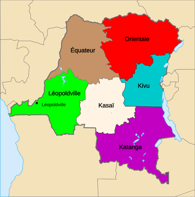
| Descripción | Map of the provinces of the Belgian Congo, from 1933 until Independence (1960). |
| Fecha | |
| Fuente | Trabajo propio, basado en: Congo Kinshasa Template.svg de Moyogo |
| Autor | Themightyquill |
| SVG desarrollo |
Licencia
Este archivo se encuentra bajo la licencia Creative Commons Genérica de Atribución/Compartir-Igual 3.0.
- Eres libre:
- de compartir – de copiar, distribuir y transmitir el trabajo
- de remezclar – de adaptar el trabajo
- Bajo las siguientes condiciones:
- atribución – Debes otorgar el crédito correspondiente, proporcionar un enlace a la licencia e indicar si realizaste algún cambio. Puedes hacerlo de cualquier manera razonable pero no de manera que sugiera que el licenciante te respalda a ti o al uso que hagas del trabajo.
- compartir igual – En caso de mezclar, transformar o modificar este trabajo, deberás distribuir el trabajo resultante bajo la misma licencia o una compatible como el original.
Registro original de carga
This image is a derivative work of the following images:
- Congo CrisisMap.png licensed with Cc-by-sa-3.0-migrated-with-disclaimers, GFDL-en
- 2010-08-10T13:57:01Z Beao 440x404 (11149 Bytes) Transparent.
- 2006-10-09T17:13:25Z Kelovy 440x404 (10193 Bytes) == Opis súboru == Map of Territorial Control during the Congo Crisis (1960-61). Color Key *'''Yellow''': National Government based in Léopoldville *'''Red''': Rival National Government based in Stanleyville *'''Green''':
- Congo Kinshasa Template.svg licensed with Cc-by-sa-2.5,2.0,1.0, Cc-by-sa-3.0-migrated, GFDL
- 2006-07-13T08:49:51Z Moyogo 640x647 (270716 Bytes) Lualaba province is Lualaba district + Kolwezi-city district
- 2006-05-28T19:43:22Z Moyogo 640x647 (268950 Bytes) split into layers, added provinces of 1960, 1966 and 1988.
- 2006-05-26T14:57:57Z Moyogo 640x647 (180669 Bytes) improvements to the template: added border of neighbouring countries, provinces' border are uniform, colours drawn from other maps on WP.
- 2005-09-30T10:36:59Z Moyogo 650x650 (117305 Bytes) Template for Province or District maps for the Congo Kinshasa. Each province has an ID in the form Province with the name, e.g. ProvinceKatanga The Provinces are only the outline stroke, no filling Each district has an ID i
Uploaded with derivativeFX
Historial del archivo
Haz clic sobre una fecha y hora para ver el archivo tal como apareció en ese momento.
| Fecha y hora | Miniatura | Dimensiones | Usuario | Comentario | |
|---|---|---|---|---|---|
| actual | 01:45 6 dic 2010 | | 640 × 647 (180 kB) | Themightyquill | {{Information |Description=Map of the provinces of the Belgian Congo, from 1933 until Independence (1960). |Source=*File:Congo_CrisisMap.png *File:Congo_Kinshasa_Template.svg |Date=2010-12-06 01:20 (UTC) |Author=*File:Congo_CrisisMap.png |
Usos del archivo
No hay páginas que enlacen a este archivo.
Uso global del archivo
Las wikis siguientes utilizan este archivo:
- Uso en de.wikipedia.org
- Uso en en.wikipedia.org
- Uso en fr.wikipedia.org
- Uso en ja.wikipedia.org
- Uso en nl.wikipedia.org
- Uso en sk.wikipedia.org
- Uso en zh.wikipedia.org