
Archivo:Asia Europe transcontinental.png

Tamaño de esta previsualización: 763 × 599 píxeles. Otras resoluciones: 306 × 240 píxeles · 611 × 480 píxeles · 978 × 768 píxeles · 1268 × 996 píxeles.
Ver la imagen en su resolución original (1268 × 996 píxeles; tamaño de archivo: 46 kB; tipo MIME: image/png)
| Descripción |
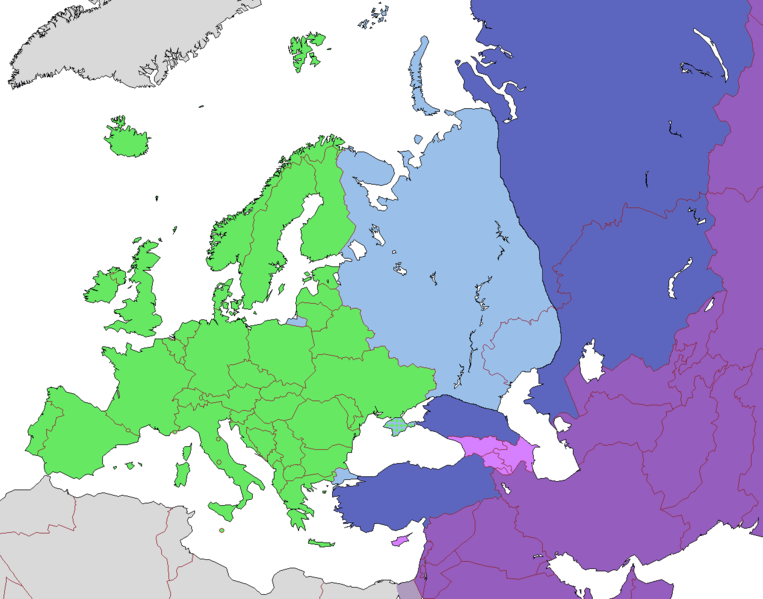
English: Map of Europe, indicating continental boundary (by Britannica and Great Soviet Encyclopedia) and transcontinental states.
States geographically in Europe (excepting overseas possessions)
Transcontinental states, European territory
Transcontinental states, Asian territory
Asian countries, sometimes referred to as Europe according to political, economic, and historical and cultural criteria (Azerbaijan, Armenia, Georgia, Cyprus)
Geographically Asian states (island states of Cyprus and Bahrain usually grouped with Asia geographically)
Asian part of Egypt Русский: Карта Европы с указанием границ частей света (по БСЭ и Британнике) и трансконтинентальных государств.
Государства, расположенные в Европе (за исключением заморских владений)
Трансконтинентальные государства, европейская территория
Трансконтинентальные государства, азиатская территория
Государства Азии, иногда относимые к Европе по политическим, экономическим, и историко-культурным критериям
Государства, расположенные в Азии
Азиатская часть Египта |
| Fecha | |
| Fuente | |
| Autor |
.png)
Licencia
Este archivo se encuentra bajo la licencia Creative Commons Genérica de Atribución/Compartir-Igual 3.0.
- Eres libre:
- de compartir – de copiar, distribuir y transmitir el trabajo
- de remezclar – de adaptar el trabajo
- Bajo las siguientes condiciones:
- atribución – Debes otorgar el crédito correspondiente, proporcionar un enlace a la licencia e indicar si realizaste algún cambio. Puedes hacerlo de cualquier manera razonable pero no de manera que sugiera que el licenciante te respalda a ti o al uso que hagas del trabajo.
- compartir igual – En caso de mezclar, transformar o modificar este trabajo, deberás distribuir el trabajo resultante bajo la misma licencia o una compatible como el original.
| Annotations | This image is annotated: View the annotations at Commons |
Historial del archivo
Haz clic sobre una fecha y hora para ver el archivo tal como apareció en ese momento.
| Fecha y hora | Miniatura | Dimensiones | Usuario | Comentario | |
|---|---|---|---|---|---|
| actual | 10:23 14 nov 2022 | | 1268 × 996 (46 kB) | Рагин1987 | Highlighted with a light purple hue the countries of Asia, sometimes attributed to Europe according to political, economic, and historical and cultural criteria (Transcaucasia, Cyprus). |
| 12:02 29 ago 2022 |  | 1268 × 996 (46 kB) | Рагин1987 | Small correction | |
| 07:03 18 feb 2020 |  | 1268 × 996 (56 kB) | Insider | fix: mixed color. not dark blue | |
| 06:55 18 feb 2020 |  | 1268 × 996 (60 kB) | Insider | Reverted to version as of 07:01, 13 October 2014 (UTC) Crimea that is Europe | |
| 09:04 10 feb 2020 |  | 1268 × 996 (84 kB) | Compu wiki | Крым — это Россия. Crimea is Russia. | |
| 07:01 13 oct 2014 |  | 1268 × 996 (60 kB) | Insider | Reverted to version as of 10:10, 1 July 2014 Crimea that is Europe | |
| 12:31 11 oct 2014 |  | 1268 × 996 (84 kB) | Michael1238 | Crimea | |
| 10:10 1 jul 2014 |  | 1268 × 996 (60 kB) | Insider | {{Information |Description={{en|1= Map of Europe, indicating continental boundary and transcontinental states. {{legend|#67e836|States geographically in Europe (excepting overseas possessions; island states UK, Ireland, Iceland and Malta usually group... |
Usos del archivo
No hay páginas que enlacen a este archivo.
Uso global del archivo
Las wikis siguientes utilizan este archivo:
- Uso en hy.wikipedia.org
- Uso en kk.wikipedia.org
- Uso en ru.wikipedia.org