
Archivo:ArmaenCaldas.png
Tamaño de esta previsualización: 788 × 600 píxeles. Otras resoluciones: 315 × 240 píxeles · 631 × 480 píxeles · 1009 × 768 píxeles · 1280 × 974 píxeles · 2300 × 1751 píxeles.
Ver la imagen en su resolución original (2300 × 1751 píxeles; tamaño de archivo: 3,5 MB; tipo MIME: image/png)
| Descripción |
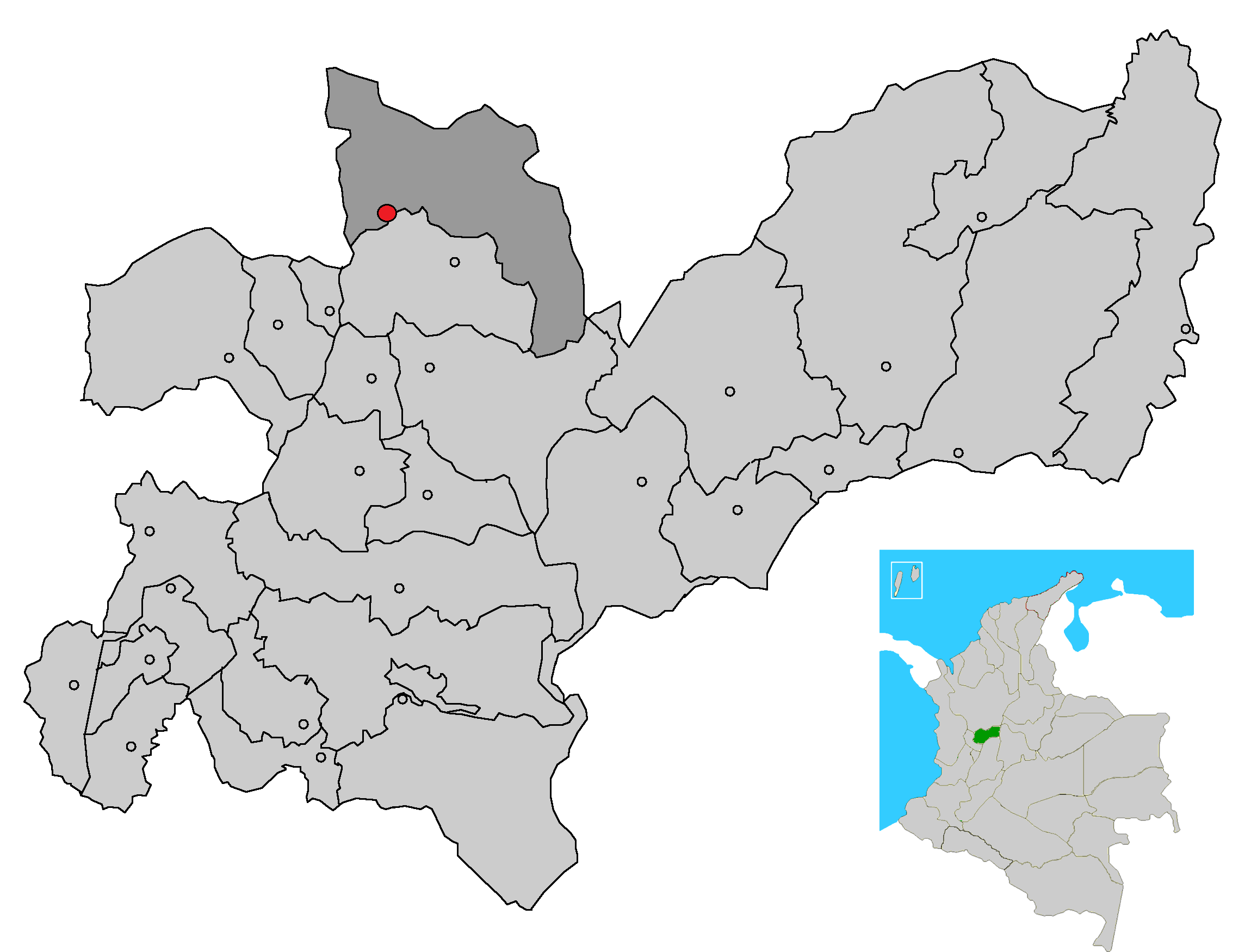
Image depicting map location of the town and municipality of Aguadas in Caldas Department, Colombia
|
| Fecha | (UTC) |
| Fuente | |
| Autor |
|
| Esta es una imagen retocada, lo que significa que ha sido alterada digitalmente de su versión original. Modificaciones: just fusioned the two pics to make an exactly pointing of Arma, Caldas's Location on the map without deleting the other municipalities in Caldas. La original se puede ver aquí: CorregimArmaAguadas.png. Las modificaciones las hizo Test.
|
Este archivo se encuentra bajo la licencia Creative Commons Genérica de Atribución/Compartir-Igual 3.0.
- Eres libre:
- de compartir – de copiar, distribuir y transmitir el trabajo
- de remezclar – de adaptar el trabajo
- Bajo las siguientes condiciones:
- atribución – Debes otorgar el crédito correspondiente, proporcionar un enlace a la licencia e indicar si realizaste algún cambio. Puedes hacerlo de cualquier manera razonable pero no de manera que sugiera que el licenciante te respalda a ti o al uso que hagas del trabajo.
- compartir igual – En caso de mezclar, transformar o modificar este trabajo, deberás distribuir el trabajo resultante bajo la misma licencia o una compatible como el original.
Registro original de carga
This image is a derivative work of the following images:
- File:MunsCaldas_Aguadas.png licensed with Cc-by-2.5, Cc-by-sa-3.0-migrated, GFDL
- 2007-04-27T20:24:07Z F3rn4nd0 2300x1751 (3583471 Bytes) {{Information |Description=Image depicting map location of the town and municipality of Aguadas in Caldas Department, Colombia |Source=own work |Date=04.27.2007 |Author=--~~~~ |Permission=GFDL - CC attribution |other_versions
- File:CorregimArmaAguadas.png licensed with Cc-by-2.5, Cc-by-sa-3.0-migrated, GFDL
- 2011-05-04T22:46:11Z Cefero3 600x584 (6419 Bytes) {{Information |Description=Image depicting map location of the town and municipality of Aguadas in Caldas Department, Colombia |Source=*[[:File:MunsCaldas_Aguadas.png|]] |Date=2011-05-04 22:42 (UTC) |Author=*[[:File:MunsCalda
Uploaded with derivativeFX
Historial del archivo
Haz clic sobre una fecha y hora para ver el archivo tal como apareció en ese momento.
| Fecha y hora | Miniatura | Dimensiones | Usuario | Comentario | |
|---|---|---|---|---|---|
| actual | 03:32 11 may 2011 | | 2300 × 1751 (3,5 MB) | Cefero3 | {{Information |Description=Image depicting map location of the town and municipality of Aguadas in Caldas Department, Colombia Just pointing out Arma Caldas on it instead of Aguadas from the original one, just for information purposses |Source=*[[:File: |
Usos del archivo
No hay páginas que enlacen a este archivo.