
Resultados de la búsqueda
Para más opciones de búsqueda, vea Ayuda:Búsqueda.
Quizás quisiste decir: geologia mars
Si consideras que este artículo debería existir, conoces nuestros pilares, dispones de fuentes fiables y sabes indicarlas como referencias, puedes crearlo, opcionalmente usando nuestro asistente.
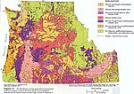 Publicaciones del IGME (2003) «Plan de cartografía geológica del IGME» [Cómo se realiza un mapa geológico] Datos: Q193842 Multimedia: Geological maps / Q193842…10 kB (1148 palabras) - 23:26 13 feb 2024
 Astrogeology. Consultado el 30 de junio de 2020. Croft, S.K. (1989). «New geological maps of Uranian satellites Titania, Oberon, Umbriel and Miranda». Proceeding…2 kB (196 palabras) - 20:46 22 ene 2024
 PMID 17812889. doi:10.1126/science.233.4759.43. Croft, S.K. (1989). «New geological maps of Uranian satellites Titania, Oberon, Umbriel and Miranda». Proceeding…2 kB (228 palabras) - 12:55 22 ene 2024
 "Plumbing Depths to Reach New Heights: Marie Tharp Explains Marine Geological Maps." The Library of Congress Information Bulletin. Consultado en junio…10 kB (1157 palabras) - 18:08 14 mar 2024
 14,918-32. doi:10.1029/JA092iA13p14918. Croft, S.K. (1989). «New geological maps of Uranian satellites Titania, Oberon, Umbriel and Miranda». Proceeding…3 kB (265 palabras) - 10:01 23 ene 2024
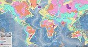 «Geologic Province and Thermo-Tectonic Age Maps». Earthquake Hazards Program. United States Geological Survey. Archivado desde el original el 7 de junio…4 kB (187 palabras) - 13:55 14 nov 2023
 Scientific Background. Rapid Instrumental Intensity Maps.». Earthquake Hazards Program. U. S. Geological Survey. Archivado desde el original el 3 de junio…4 kB (349 palabras) - 07:51 15 feb 2024
 Geológico y Minero de España). 1991. Savage, J.F.; Boschma, F (1980). «Geological maps of the Southern Cantabrian Mountains (Spain)» (PDF). Leidse Geologische…8 kB (831 palabras) - 18:41 25 nov 2023
 de 2014. Snyder, John Parr (1982). Map Projections Used by the U.S. Geological Survey (en inglés) (Segunda edición). U.S. Government Printing Office…7 kB (242 palabras) - 00:17 2 ene 2024
- org/web/20091027192037/http://earthquake.usgs.gov/eqcenter/</link> <dc:publisher>U.S. Geological Survey</dc:publisher> <pubDate>Thu, 27 Dec 2007 23:56:15 PST</pubDate>…9 kB (956 palabras) - 06:19 7 nov 2023
 Report on the recent work of the Geological Survey in the north-west Highlands of Scotland, based on field notes and maps by Messrs. B.N. Peach, J. Horne…4 kB (536 palabras) - 16:12 27 ene 2024
 2010. San Rafael Recreation Element of the General Plan, June, 1984 U.S. Geological Survey, Topographical Map, San Quentin 7.5 Minute Quadrangle, revised…4 kB (373 palabras) - 17:03 9 ene 2024
- de 2014. Snyder, John Parr (1982). Map Projections Used by the U.S. Geological Survey (en inglés) (Segunda edición). U.S. Government Printing Office…4 kB (232 palabras) - 22:55 25 oct 2023
- de 2014. Snyder, John Parr (1982). Map Projections Used by the U.S. Geological Survey (en inglés) (Segunda edición). U.S. Government Printing Office…4 kB (232 palabras) - 22:54 25 oct 2023
- de 2014. Snyder, John Parr (1982). Map Projections Used by the U.S. Geological Survey (en inglés) (Segunda edición). U.S. Government Printing Office…5 kB (232 palabras) - 22:55 25 oct 2023
 Afganistán. Bolt, B.A., W.L. Horn, G.A. Macdonald and R.F. Scott, (1975) Geological hazards: earthquakes, tsunamis, volcanoes, avalanches, landslides, floods…4 kB (278 palabras) - 19:14 18 ene 2024
 Center. U.S. Geological Survey. Consultado el 14 de agosto de 2013. «Maps / Products». USGS Astrogeology Science Center. US Geological Survey. Consultado…3 kB (285 palabras) - 17:16 26 ene 2024
- de 2014. Snyder, John Parr (1982). Map Projections Used by the U.S. Geological Survey (en inglés) (Segunda edición). U.S. Government Printing Office…8 kB (230 palabras) - 22:54 25 oct 2023
- de 2014. Snyder, John Parr (1982). Map Projections Used by the U.S. Geological Survey (en inglés) (Segunda edición). U.S. Government Printing Office…11 kB (233 palabras) - 23:02 25 oct 2023
 Projections—A Working Manual», Professional Paper (1395), United States Geological Survey, pp. 138-0, archivado desde el original el 1 de julio de 2010,…2 kB (233 palabras) - 04:48 25 jun 2020


