
Archivo:Operation Azul.jpg
Tamaño de esta previsualización: 800 × 465 píxeles. Otras resoluciones: 320 × 186 píxeles · 640 × 372 píxeles · 1024 × 595 píxeles · 1280 × 744 píxeles · 2040 × 1185 píxeles.
Ver la imagen en su resolución original (2040 × 1185 píxeles; tamaño de archivo: 449 kB; tipo MIME: image/jpeg)
Resumen
Drawn by myself (Max Smith) in Visio.
Re-uploaded as JPG - big PNGs don't seem to work.
Released into the public domain, but a credit would be nice.
Based on a map in Martin Middlebrook's : The Fight For The Malvinas.
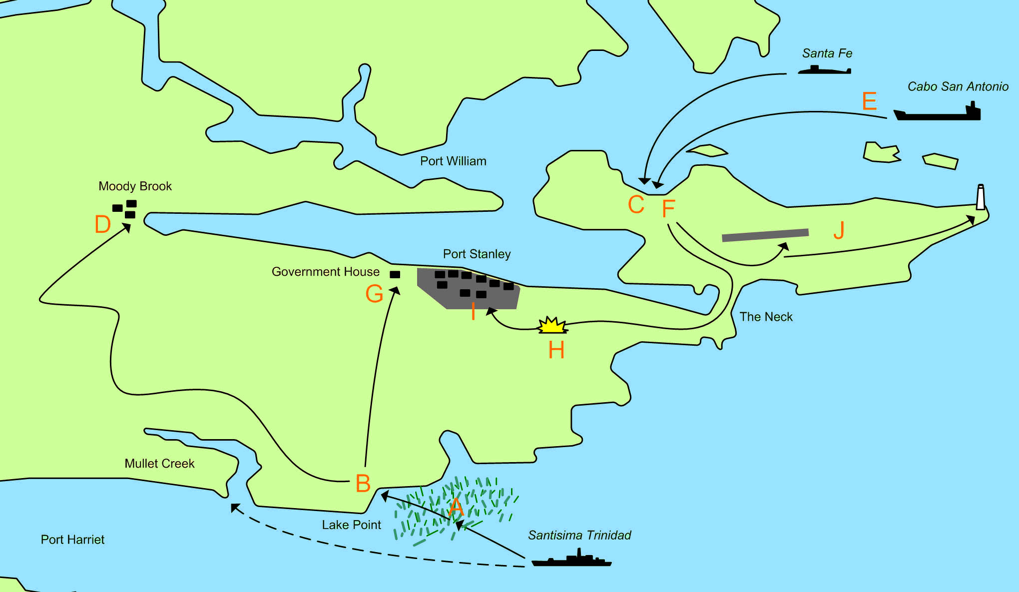
The map showing the area of the Falkland Islands around Port Stanley and the actions of 1 April 1982 and 2 April 1982 during the 1982 Invasion of the Falkland Islands.

|
File:Operation Azul.svg es una versión vectorial de este archivo. Debería usarse esa versión en lugar de este archivo JPG, cuando sea mejor.
File:Operation Azul.jpg → File:Operation Azul.svg
Para más información, lee Ayuda:SVG. |
 |
- A. 21:30 1 April - The Type 42 destroyerSantisima Trinidad begins loading marines of the Amphibious Commando Company into 21 small inflatable motor boats. These set out for Mullet Creek at but sail too far north and are caught up in beds of Kelp, which cause problems for the boats. They decide to head for the nearest beach, which is near Lake Point.
- B. 23:00 1 April - The first group of 91 men lands on an unamed beach at Lake Point. The group splits into a smaller force commanded by Lieutenant-Commander Giachino who head towards Government House, and a larger force commanded by Lieutenant-Commander Sabarots who head towards Moody Brook Barracks.
- C. 04:30 2 April - A small advanced group from Buzos Tacticos is landed from the Submarine Santa Fe.
- D. 05:30 2 April - Lieutenant-Commander Sabarots force reaches and surrounds the Barracks. They throw tear gas grenades into the buildings and fire machine gun tracer over the buildings. They find the buildings are deserted.
- E. 06:00 2 April - 20 FMC Amtracs and several LARC 5 stores carrying vehicles are launched from Caba San Antionio. The force splits into 3 groups:
- A four Amtrac vanguard. Including one carrying the Army Platoon.
- The main force of 14 Amtracs.
- The second in command, a recovery Amtrac and LARC vehciles.
- F. 06:30 2 April - The first Amtracs land and meet no resistance. The Army platoon captures the deserted airport.
- G. 06:30 2 April - The 5 man Argentine force reaches government house, where they are stopped by 31 Royal Marines, 11 armed Royal Navy men and 1 locals. Two Argentines are wounded (one would later die), and the remaining 3 are captured.
- H. 07:15 2 April - Having met no resistance, the Argentine Amtracs advance on Stanley, when they are ambushed from a house about 500 meters from the road. Royal Marines use rockets and machine gun fire. The Royal Marines fall back to government house. One of the Amtracs is scarred by machine gun fire, and there is one minor injury.
- I. 08:00 2 April - The Argentine Amtrac force secures Port Stanley.
- J. The Army platoon begins clearing the runway and seizes the light house.
Licencia
| Yo, el titular de los derechos de autor de esta obra, lo libero al dominio público. Esto aplica en todo el mundo. En algunos países esto puede no ser legalmente factible; si ello ocurriese: Concedo a cualquier persona el derecho de usar este trabajo para cualquier propósito, sin ningún tipo de condición al menos que éstas sean requeridas por la ley. |
Historial del archivo
Haz clic sobre una fecha y hora para ver el archivo tal como apareció en ese momento.
| Fecha y hora | Miniatura | Dimensiones | Usuario | Comentario | |
|---|---|---|---|---|---|
| actual | 22:27 10 mar 2011 | | 2040 × 1185 (449 kB) | Megapixie | Fix colors. |
| 11:54 26 nov 2006 |  | 2040 × 1185 (159 kB) | Electionworld | == Summary == Drawn by myself (Max Smith) in Visio. Re-uploaded as JPG - big PNGs don't seem to work. Released into the public domain, but a credit would be ''nice''. Based on a map in Martin Middlebrook's : ''The Fight For The Malvinas''. The map sho |
Usos del archivo
Las siguientes páginas usan este archivo:
Uso global del archivo
Las wikis siguientes utilizan este archivo:
- Uso en ar.wikipedia.org
- Uso en ceb.wikipedia.org
- Uso en en.wikipedia.org
- Uso en fi.wikipedia.org
- Uso en fr.wikipedia.org
- Uso en he.wikipedia.org
- Uso en hu.wikipedia.org
- Uso en ja.wikipedia.org
- Uso en no.wikipedia.org
- Uso en pl.wikipedia.org
- Uso en ru.wikipedia.org
- Uso en sl.wikipedia.org
- Uso en www.wikidata.org