
Archivo:Apsley house on an 1869 Ordnance Survey Map.JPG
No se dispone de una resolución más alta.
Apsley_house_on_an_1869_Ordnance_Survey_Map.JPG (500 × 492 píxeles; tamaño de archivo: 79 kB; tipo MIME: image/jpeg)

|
Este archivo se trasladó a Wikimedia Commons desde en.wikipedia por secuencia de comandos mediante un bot. Todas las fuentes de información todavía están presentes. Se requiere revisión. Además, puede haber errores en cualquiera o en todos los campos de información, la información sobre este archivo no debe considerarse fiable y el archivo no debe utilizarse hasta que haya sido revisada y corregida. Una vez que el examen se haya completado, esta plantilla debe ser eliminada. Para más detalles, véase más adelante. Compruébelo ahora! |
| Descripción |
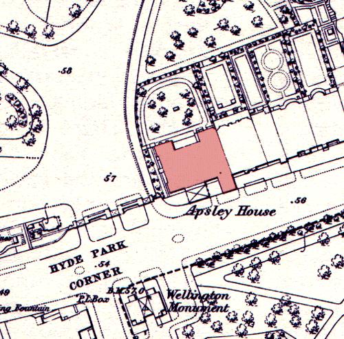
English: Apsley House on an 1869 Ordnance Survey map, showing its position at the end of a terrace. The neighbouring houses were demolished in the post World War II period to allow Park Lane to be straightened and widened. The Wellington Monument has been moved since this time. |
| Fecha | 15 de mayo de 2005 (fecha original de carga) |
| Fuente | Transferido desde en.wikipedia a Commons por Oxyman usando CommonsHelper. |
| Autor | The original uploader was Oliver Chettle de Wikipedia en inglés. |
Licencia
This work is an Ordnance Survey map over 50 years old, which is covered by Crown Copyright which in this case expires 50 years after publication. Ordnance Survey does however ask that they be credited and that the date of publication be given.
Any ancillary rights gained through the creation of the electronic version are granted as freely usable under any circumstances.
|
Esta obra creada por el Gobierno del Reino Unido está en el dominio público porque se cumple una de las siguientes:
HMSO declaró que la expiración de los derechos de autor de la Corona se aplica en todo el mundo (ref: HMSO Email Reply)
|
 |
Registro original de carga
Aquí se muestra la página de descripción original. Los siguientes nombres de usuario se refieren a en.wikipedia.
- 2005-05-15 08:53 Oliver Chettle 500×492× (80749 bytes) Apsley House on an 1869 [[Ordnance Survey]] map, showing its position at the end of a terrace. The neighbouring houses were demolished in the post [[World War II]] period to allow [[Park Lane]] to be widened. The [[Wellington Monument]] has been moved sin
Historial del archivo
Haz clic sobre una fecha y hora para ver el archivo tal como apareció en ese momento.
| Fecha y hora | Miniatura | Dimensiones | Usuario | Comentario | |
|---|---|---|---|---|---|
| actual | 23:23 5 oct 2009 | | 500 × 492 (79 kB) | File Upload Bot (Magnus Manske) | {{BotMoveToCommons|en.wikipedia|year={{subst:CURRENTYEAR}}|month={{subst:CURRENTMONTHNAME}}|day={{subst:CURRENTDAY}}}} {{Information |Description={{en|Apsley House on an 1869 en:Ordnance Survey map, showing its position at the end of a terrace. The |
Usos del archivo
La siguiente página usa este archivo:
Uso global del archivo
Las wikis siguientes utilizan este archivo:
- Uso en ar.wikipedia.org
- Uso en en.wikipedia.org
- Uso en fr.wikipedia.org
- Uso en ja.wikipedia.org
- Uso en zh.wikipedia.org