
Archivo:Earthquake wave paths.png

Earthquake_wave_paths.png (300 × 250 píxeles; tamaño de archivo: 13 kB; tipo MIME: image/png)

|
File:Earthquake wave paths.svg es una versión vectorial de este archivo. Debería usarse esa versión en lugar de este archivo PNG, cuando sea mejor.
File:Earthquake wave paths.png → File:Earthquake wave paths.svg
Para más información, lee Ayuda:SVG. |
 |
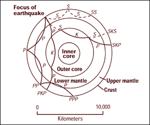
Cross section of the whole Earth, showing the complexity of paths of earthquake waves. The paths curve because the different rock types found at different depths change the speed at which the waves travel. Solid lines marked P are compressional waves; dashed lines marked S are shear waves. S waves do not travel through the core but may be converted to compressional waves (marked K) on entering the core (PKP, SKS). Waves may be reflected at the surface (PP, PPP, SS).
Seismographs detect the various types of waves. Analysis of such records reveals structures within the Earth.
Source: http://pubs.usgs.gov/gip/interior/fig2.gif ; original upload in english wikipedia, 15 April 2005 by SEWilco
Esta imagen está en el dominio público, ya que contiene materiales que originalmente vinieron del Servicio Geológico de los Estados Unidos de América, una agencia del Departamento del Interior. Para obtener más información, consulte la política oficial de derechos de los USGS.
|
Registro original de carga
| Fecha y hora | Dimensiones | Usuario | Comentario |
|---|---|---|---|
| 4 de septiembre de 2005, 12:53:16 | 300 × 250 (13208 bytes) | Saperaud (discusión · contribs.) | Cross section of the whole [[Earth]], showing the complexity of paths of [[earthquake]] waves. The paths curve because the different rock types found at different depths change the speed at which the waves travel. Solid lines marked P are compressional wa |
Historial del archivo
Haz clic sobre una fecha y hora para ver el archivo tal como apareció en ese momento.
| Fecha y hora | Miniatura | Dimensiones | Usuario | Comentario | |
|---|---|---|---|---|---|
| actual | 16:54 6 ene 2015 | | 300 × 250 (13 kB) | GifTagger | Bot: Converting file to superior PNG file. (Source: Earthquake_wave_paths.gif). This GIF was problematic due to non-greyscale color table. |
Usos del archivo
La siguiente página usa este archivo:
Uso global del archivo
Las wikis siguientes utilizan este archivo:
- Uso en ary.wikipedia.org
- Uso en cs.wikipedia.org
- Uso en de.wikipedia.org
- Uso en en.wikipedia.org
- Uso en fi.wikipedia.org
- Uso en fr.wikipedia.org
- Uso en it.wikipedia.org
- Uso en nds.wikipedia.org
- Uso en sk.wikipedia.org
- Stavba Zeme
- Gutenbergova diskontinuita
- Portál:Vedy o Zemi
- Portál:Vedy o Zemi/Odporúčané články
- Portál:Vedy o Zemi/Odporúčaný článok/15 2007
- Portál:Vedy o Zemi/Odporúčaný článok/42 2007
- Portál:Vedy o Zemi/Odporúčané články/2007
- Portál:Vedy o Zemi/Odporúčaný článok/15
- Portál:Vedy o Zemi/Odporúčaný článok/53
- Uso en tr.wikipedia.org
- Uso en vi.wikipedia.org
- Uso en zh-yue.wikipedia.org
- Uso en zh.wikipedia.org