
Archivo:AfricaLocation.svg

Tamaño de esta previsualización PNG del archivo SVG: 463 × 236 píxeles. Otras resoluciones: 320 × 163 píxeles · 640 × 326 píxeles · 1024 × 522 píxeles · 1280 × 652 píxeles · 2560 × 1305 píxeles.
Ver la imagen en su resolución original ((Imagen SVG, nominalmente 463 × 236 pixels, tamaño de archivo: 290 kB))
Resumen
| Descripción |
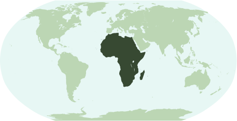
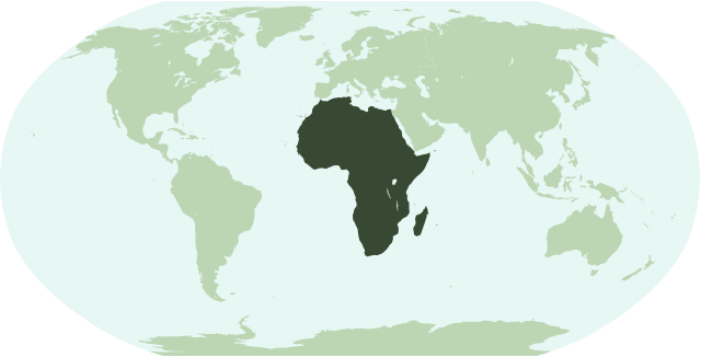
English: Map showing the location of the continent of Africa (including indian ocean islands near Madagascar).
Français : Une carte pour démontrer la location du continent de l'Afrique (avec des îles d'océan indien près de Madagasque).
Interlingua: Un Mapa monstrante le location del continente de Africa (con insulas del oceano indian juxta Madagascar). |
| Fecha | |
| Fuente | Trabajo propio |
| Autor | Notscott |
Licencia
| Yo, el titular de los derechos de autor de esta obra, lo libero al dominio público. Esto aplica en todo el mundo. En algunos países esto puede no ser legalmente factible; si ello ocurriese: Concedo a cualquier persona el derecho de usar este trabajo para cualquier propósito, sin ningún tipo de condición al menos que éstas sean requeridas por la ley. |
Historial del archivo
Haz clic sobre una fecha y hora para ver el archivo tal como apareció en ese momento.
| Fecha y hora | Miniatura | Dimensiones | Usuario | Comentario | |
|---|---|---|---|---|---|
| actual | 01:23 15 ene 2007 | | 463 × 236 (290 kB) | Notscott | {{en|Map showing the location of the continent of Africa (including indian ocean islands near Madagascar).}} {{fr|Une carte pour démontrer la location du continent de l'Afrique (avec des îles d'océan indien près de Madagasque).}} {{ia|Un Mapa monstran |
| 23:50 14 ene 2007 |  | 463 × 236 (290 kB) | Notscott | {{en|Map showing the location of the continent of Africa (including indian ocean islands near Madagascar).}} {{fr|Une carte pour démontrer la location du continent d'Afrique (avec des îles d'océan indien près de Madagasque).}} {{ia|Un Mapa monstrante |
Usos del archivo
La siguiente página usa este archivo:
Uso global del archivo
Las wikis siguientes utilizan este archivo:
- Uso en arz.wikipedia.org
- جنوب السودان
- ليبيا
- مصر
- جمهورية كونجو الديموقراطيه
- زيمبابوى
- اسواتينى
- سينيجال
- رواندا
- اوجاندا
- ثيويتا
- الجزاير
- سانت هيلينا
- قالب:افريقيا
- قالب:امريكا الجنوبية/شرح
- قالب:شرح استعمال قوالب القارات
- اريتريا
- شمال افريقيا
- شرق افريقيا
- وسط افريقيا
- كوت ديفوار
- جيبوتى
- بوركينا فاسو
- بوتسوانا
- افريقيا الوسطى
- الاحزاب السياسية فى تونس
- الاحزاب السياسية فى جنوب السودان
- الاحزاب السياسية فى السودان
- الاحزاب السياسيه فى المغرب
- جمهورية الكونجو
- جينيا
- جامبيا
- لغات مصر
- قالب:الاحزاب السياسيه فى دول افريقيا
- قالب:اناشيد دول افريقيا الوطنيه
- قالب:جامعات افريقيا
- Uso en avk.wikipedia.org
- Uso en bi.wikipedia.org
- Uso en bm.wikipedia.org
- Uso en bpy.wikipedia.org
- Uso en cbk-zam.wikipedia.org
- Uso en ch.wikipedia.org
- Uso en en.wikipedia.org
Ver más uso global de este archivo.