
Archivo:Wax Lake Delta.jpg
No se dispone de una resolución más alta.
Wax_Lake_Delta.jpg (292 × 256 píxeles; tamaño de archivo: 84 kB; tipo MIME: image/jpeg)
| Descripción |
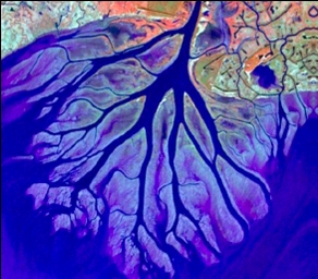
English: The Wax Lake Delta was formed by the deposition of sediment from a shipping canal off of the Atchafalaya River. The channel was routed through Wax Lake, which quickly filled with sediment. After Wax Lake filled, the sediment from the canal deposited offshore and created the delta. |
|||
| Fecha | ||||
| Fuente | National Center for Earth-surface Dynamics; http://www.nced.umn.edu/printview/Field_Site_Wax_Lake_Delta | |||
| Autor | National Center for Earth-surface Dynamics | |||
| Permiso (Reutilización de este archivo) |
|

| Posición de la cámara | | Ubicación de esta y otras imágenes en: OpenStreetMap |
|---|
Historial del archivo
Haz clic sobre una fecha y hora para ver el archivo tal como apareció en ese momento.
| Fecha y hora | Miniatura | Dimensiones | Usuario | Comentario | |
|---|---|---|---|---|---|
| actual | 21:02 19 dic 2008 | | 292 × 256 (84 kB) | Awickert | {{Information |Description={{en|1=The Wax Lake Delta was formed by the deposition of sediment from a shipping canal off of the Atchafalaya River. The channel was routed through Wax Lake, which quickly filled with sediment. After Wax Lake filled, the sedim |
Usos del archivo
La siguiente página usa este archivo:
Uso global del archivo
Las wikis siguientes utilizan este archivo:
- Uso en de.wikipedia.org
- Uso en en.wikipedia.org
- Uso en fr.wikipedia.org
- Uso en www.wikidata.org