
Archivo:Trans Alaska Pipeline Denali fault shift.jpg
Tamaño de esta previsualización: 800 × 600 píxeles. Otras resoluciones: 320 × 240 píxeles · 640 × 480 píxeles · 1024 × 768 píxeles · 1280 × 960 píxeles · 2560 × 1920 píxeles.
Ver la imagen en su resolución original (2560 × 1920 píxeles; tamaño de archivo: 570 kB; tipo MIME: image/jpeg)
Resumen
| Descripción |
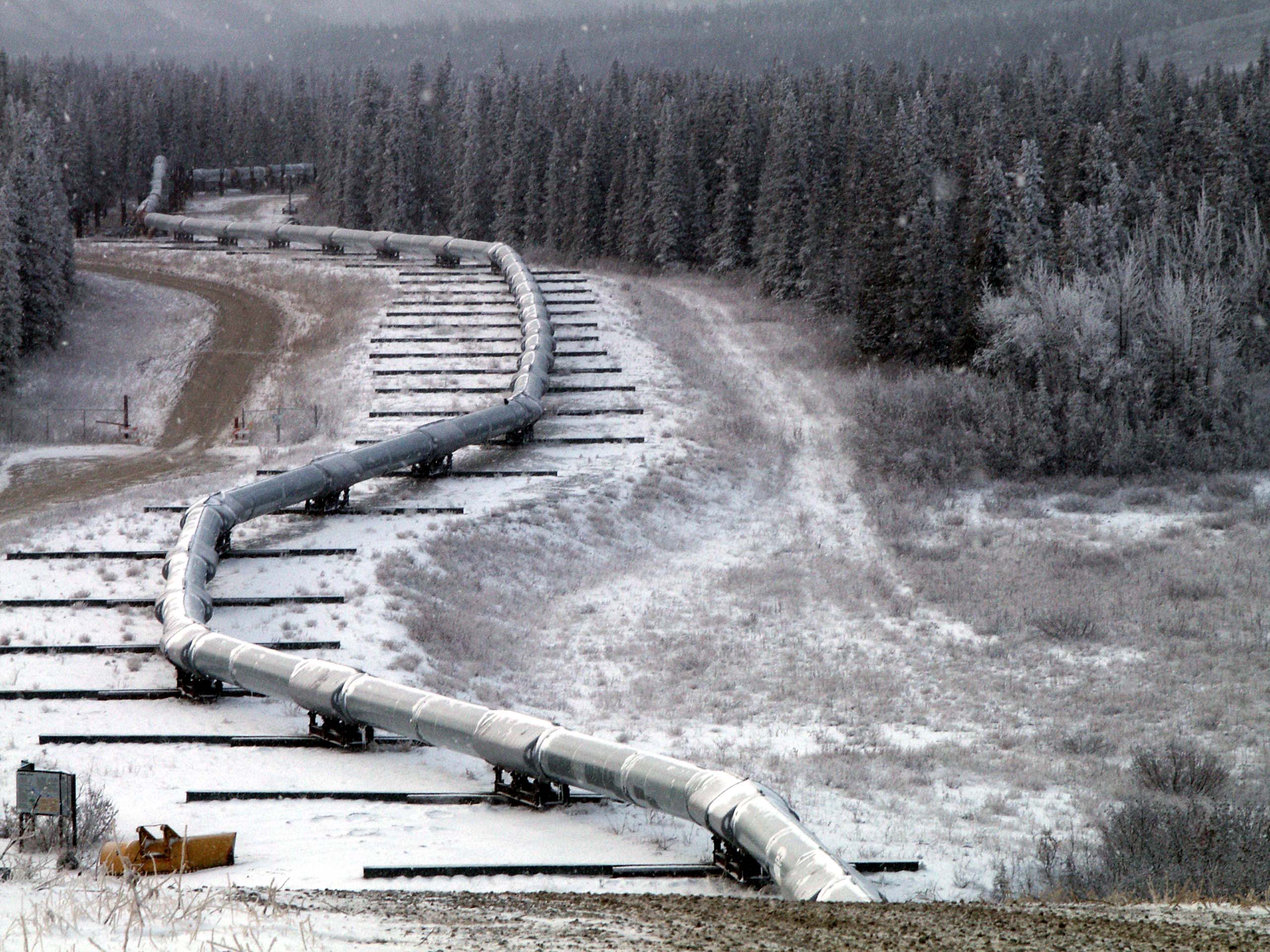
English: Trace of the Denali Fault after the 7.9 magnitude earthquake of 3 November 2002, Alaska, USA. View south along the Trans-Alaska Pipeline System in the zone where it was engineered to cross the fault (the pipeline rests on sliders rather than rigid pillar supports). The fault trace passes beneath the pipeline between the 2nd and 3rd slider supports at the far end of the zone. A large arc in the pipe can be seen in the pipe on the right, due to shortening of the zigzag-shaped pipeline trace within the fault zone. It was snowing when the photo was taken. |
| Fecha | |
| Fuente | Denali Fault Earthquake Photos 07 Nov 2002 (Direct link) |
| Autor | U.S. Geological Survey employee |
| Posición de la cámara | | Ubicación de esta y otras imágenes en: OpenStreetMap |
|---|
Licencia
Esta imagen está en el dominio público, ya que contiene materiales que originalmente vinieron del Servicio Geológico de los Estados Unidos de América, una agencia del Departamento del Interior. Para obtener más información, consulte la política oficial de derechos de los USGS.
|
Historial del archivo
Haz clic sobre una fecha y hora para ver el archivo tal como apareció en ese momento.
| Fecha y hora | Miniatura | Dimensiones | Usuario | Comentario | |
|---|---|---|---|---|---|
| actual | 05:58 4 ago 2007 | | 2560 × 1920 (570 kB) | Whhalbert | |
| 05:55 4 ago 2007 |  | 800 × 600 (137 kB) | Whhalbert | == Summary == Alaska Denali Fault after November 3rd 7.9 magnitude earthquake: November 7, 2002. View south along the Trans-Alaska Pipeline System in the zone where it was engineered for the Denali fault. The fault trace passes beneath th |
Usos del archivo
La siguiente página usa este archivo:
Uso global del archivo
Las wikis siguientes utilizan este archivo:
- Uso en de.wikipedia.org
- Uso en en.wikipedia.org
- Uso en en.wikibooks.org
- Uso en fa.wikipedia.org
- Uso en fi.wikipedia.org
- Uso en fr.wikipedia.org
- Uso en ja.wikipedia.org
- Uso en nl.wikipedia.org
- Uso en pl.wikipedia.org
- Uso en ru.wikipedia.org
- Uso en th.wikipedia.org
- Uso en tr.wikipedia.org
- Uso en zh.wikipedia.org