
Archivo:Southern United States Civil War map.png
No se dispone de una resolución más alta.
Southern_United_States_Civil_War_map.png (566 × 365 píxeles; tamaño de archivo: 6 kB; tipo MIME: image/png)

|
Esta imagen debería volverse a crear como imágenes vectoriales SVG. Esto proporciona muchas ventajas, véase Commons:Media for cleanup (en inglés) para más información. Si ya hay una versión SVG de esta imagen disponible, por favor súbala a Commons. Tras subirla, reemplace esta plantilla con la plantilla
{{vector version available|nuevo nombre de imagen.svg}} en esta imagen. |
Resumen
| Descripción |
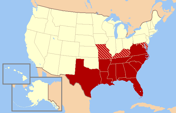
English: Historic map of Southern United States, based on Civil War allegiances. The states in solid red seceded from the Union to form the Confederate States of America, while the striped states - Missouri, Kentucky, Maryland, and Delaware - were "Border States," slave states that did not secede from the Union to join the Confederacy. Oklahoma (not yet a state) was then Indian Territory. The Northern Counties of Virginia chose to remain in the Union and in 1863 became the state of West Virginia. |
| Fuente | Trabajo propio |
| Autor | Gator87 |
Licencia
Yo, el titular de los derechos de autor de esta obra, la publico en los términos de la siguiente licencia:

|
Se autoriza la copia, distribución y modificación de este documento bajo los términos de la licencia de documentación libre GNU, versión 1.2 o cualquier otra que posteriormente publique la Fundación para el Software Libre; sin secciones invariables, textos de portada, ni textos de contraportada. Se incluye una copia de la dicha licencia en la sección titulada Licencia de Documentación Libre GNU. |
| Este archivo se encuentra bajo la licencia Creative Commons Genérica de Atribución/Compartir-Igual 3.0. | ||
| ||
| Esta etiqueta de licencia fue agregada a este archivo como parte de la actualización de la licencia GFDL. |
Historial del archivo
Haz clic sobre una fecha y hora para ver el archivo tal como apareció en ese momento.
| Fecha y hora | Miniatura | Dimensiones | Usuario | Comentario | |
|---|---|---|---|---|---|
| actual | 22:13 13 jun 2010 | | 566 × 365 (6 kB) | Ras67 | cropped |
| 02:53 11 feb 2007 |  | 572 × 371 (19 kB) | Gator87~commonswiki | Map of Historic Southern United States. States in red were in the Confederacy, whereas the striped states - Missouri, Kentucky, Maryland, and Delaware - were considered "Border States" that remained in the Union, though they gave varying degrees of suppo |
Usos del archivo
No hay páginas que enlacen a este archivo.
Uso global del archivo
Las wikis siguientes utilizan este archivo:
- Uso en eu.wikipedia.org
- Uso en nl.wikipedia.org
- Uso en simple.wikipedia.org
- Uso en vi.wikipedia.org
- Uso en zh.wikipedia.org