
Archivo:Satellite image of Spain in January 2003.jpg

Tamaño de esta previsualización: 714 × 600 píxeles. Otras resoluciones: 286 × 240 píxeles · 571 × 480 píxeles · 914 × 768 píxeles · 1219 × 1024 píxeles · 2437 × 2048 píxeles · 4175 × 3508 píxeles.
Ver la imagen en su resolución original (4175 × 3508 píxeles; tamaño de archivo: 2,42 MB; tipo MIME: image/jpeg)
| Descripción |
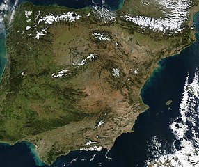
Satellite image of Spain in January 2003. Slightly cropped image, original taken from NASA's Visible Earth http://visibleearth.nasa.gov/view_rec.php?id=4989. NASA's description: The Iberian Peninsula, home to the countries of Spain and Portugal, stretches toward North Africa in this true-color Aqua MODIS image from January 24, 2003. Portugal sits on the Atlantic side of the peninsula, while Spain takes up the rest and shares a border with France to the northeast. At the bottom of the peninsula is a narrow gap between Europe and North Africa. This gap is the Strait of Gibraltar, which also serves as the buffer between the Atlantic Ocean and the Mediterranean Sea. The northern point of Morocco occupies the other side of the Strait, and farther to the east is northern Algeria. |
| Fecha | |
| Fuente | http://visibleearth.nasa.gov/view_rec.php?id=4989 |
| Autor | Jacques Descloitres, MODIS Rapid Response Team, NASA/GSFC |
| Este archivo es de dominio público porque fue creado por la NASA. Las políticas sobre copyright de la NASA estipulan que «el material de la NASA no está protegido con copyright a menos que se indique lo contrario». (Políticas sobre copyright de la NASA o Políticas sobre la utilización de imágenes del Jet Propulsion Laboratory). | ||
 |
Advertencias:
|
Historial del archivo
Haz clic sobre una fecha y hora para ver el archivo tal como apareció en ese momento.
| Fecha y hora | Miniatura | Dimensiones | Usuario | Comentario | |
|---|---|---|---|---|---|
| actual | 12:54 20 dic 2004 | | 4175 × 3508 (2,42 MB) | Hautala | {{PD-USGov-NASA}} Satellite image of Spain in January 2003. Slightly cropped image, original taken from NASA's Visible Earth http://visibleearth.nasa.gov/cgi-bin/viewrecord?24848 . Description: The Iberian Peninsula, home to the countries of Spain and Por |
Usos del archivo
La siguiente página usa este archivo:
Uso global del archivo
Las wikis siguientes utilizan este archivo:
- Uso en af.wikipedia.org
- Uso en en.wikipedia.org
- Uso en eu.wikipedia.org
- Uso en he.wikipedia.org
- Uso en ht.wikipedia.org
- Uso en hu.wikipedia.org
- Uso en incubator.wikimedia.org
- Uso en it.wikibooks.org
- Uso en it.wiktionary.org
- Uso en nl.wikipedia.org
- Uso en pt.wikipedia.org
- Uso en uk.wikipedia.org