Archivo:ROC PRC comparison eng.jpg

Contenido de la página no disponible en otros idiomas.
De Wikipedia, la enciclopedia libre

ROC_PRC_comparison_eng.jpg(770 × 600 píxeles; tamaño de archivo: 239 kB; tipo MIME: image/jpeg)

File:ROC vs PRC.svg es una versión vectorial de este archivo. Debería usarse esa versión en lugar de este archivo JPG, cuando sea mejor.

File:ROC PRC comparison eng.jpg → File:ROC vs PRC.svg

Para más información, lee Ayuda:SVG.

En otros idiomas
Alemannisch  Bahasa Indonesia  Bahasa Melayu  British English  català  čeština  dansk  Deutsch  eesti  English  español  Esperanto  euskara  français  Frysk  galego  hrvatski  Ido  italiano  lietuvių  magyar  Nederlands  norsk bokmål  norsk nynorsk  occitan  Plattdüütsch  polski  português  português do Brasil  română  Scots  sicilianu  slovenčina  slovenščina  suomi  svenska  Tiếng Việt  Türkçe  vèneto  Ελληνικά  беларуская (тарашкевіца)  български  македонски  нохчийн  русский  српски / srpski  татарча/tatarça  українська  ქართული  հայերեն  বাংলা  தமிழ்  മലയാളം  ไทย  한국어  日本語  简体中文  繁體中文  עברית  العربية  فارسی  +/−
Nueva imagen SVG

Atlas This map has been uploaded by Electionworld from en.wikipedia.org to enable the Wikimedia Atlas of the World . Original uploader to en.wikipedia.org was Pryaltonian, known as Pryaltonian at en.wikipedia.org. Electionworld is not the creator of this map. Licensing information is below.

Resumen

Descripción
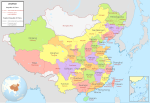
English: Comparison between Republic of China and People's Republic of China administrative divisions.
Legend details
  • Black dotted lines are political boundaries drawn by the ROC. The formal names of these political entities are in black
  • White areas represent the territories claimed by the ROC but not the PRC.
  • The names and the boundary of "South China Sea" is self-claimed by China, which has no valid supported document. Therefore, It is remain a false information and should not be visible anywhere to prevent miseducation.
Origin

Adapted into English by Pryaltonian from the Chinese Wikipedia. The original ROC map included more cities, but the adaptation removed non-central municipalities to clean up the image. Therefore, this image contains:

Republic of China

  • 35 provinces
  • 14 municipalities
  • 2 areas
  • 1 special administrative region

People's Republic of China

  • 23 provinces
  • 4 municipalities
  • 5 autonomous regions
  • 2 special administrative regions

The image also includes the addition of Chongqing as a municipality and the Gansu-Qinghai border change.

Comments, suggestions, adaptations, critiques are all welcome.
Fecha
Fuente Trabajo propio
Autor Electionworld

Licencia

GNU head Se autoriza la copia, distribución y modificación de este documento bajo los términos de la licencia de documentación libre GNU, versión 1.2 o cualquier otra que posteriormente publique la Fundación para el Software Libre; sin secciones invariables, textos de portada, ni textos de contraportada. Se incluye una copia de la dicha licencia en la sección titulada Licencia de Documentación Libre GNU.
w:es:Creative Commons
atribución compartir igual
Este archivo se encuentra bajo la licencia Creative Commons Genérica de Atribución/Compartir-Igual 3.0.
Eres libre:
  • de compartir – de copiar, distribuir y transmitir el trabajo
  • de remezclar – de adaptar el trabajo
Bajo las siguientes condiciones:
  • atribución – Debes otorgar el crédito correspondiente, proporcionar un enlace a la licencia e indicar si realizaste algún cambio. Puedes hacerlo de cualquier manera razonable pero no de manera que sugiera que el licenciante te respalda a ti o al uso que hagas del trabajo.
  • compartir igual – En caso de mezclar, transformar o modificar este trabajo, deberás distribuir el trabajo resultante bajo la misma licencia o una compatible como el original.
Esta etiqueta de licencia fue agregada a este archivo como parte de la actualización de la licencia GFDL.

GNU was used on the Chinese page, so same copyright information should apply. -Pryaltonian 04:45, 3 September 2006 (UTC)

Leyendas

Añade una explicación corta acerca de lo que representa este archivo

Elementos representados en este archivo

representa a

image/jpeg

Historial del archivo

Haz clic sobre una fecha y hora para ver el archivo tal como apareció en ese momento.

Fecha y horaMiniaturaDimensionesUsuarioComentario
actual19:48 18 ene 2015Miniatura de la versión del 19:48 18 ene 2015770 × 600 (239 kB)WwbreadPart of Bhutan and Russia was Rep. China. It has been marked in this map but not painted white. Also marked Nanking and Peking by two bigger stars.
14:03 16 dic 2006Miniatura de la versión del 14:03 16 dic 2006770 × 600 (316 kB)Electionworld{{ew|en|Pryaltonian}} == Legend details == * Black dotted lines are political boundaries drawn by the ROC. The formal names of these political entities are in black text. * Red solid lines are political boundaries drawn by the [[P

No hay páginas que enlacen a este archivo.

Uso global del archivo