
Archivo:Mount Rainier 5917s.JPG

Tamaño de esta previsualización: 709 × 600 píxeles. Otras resoluciones: 284 × 240 píxeles · 567 × 480 píxeles · 908 × 768 píxeles · 1210 × 1024 píxeles · 2420 × 2048 píxeles · 4920 × 4163 píxeles.
Ver la imagen en su resolución original (4920 × 4163 píxeles; tamaño de archivo: 4,95 MB; tipo MIME: image/jpeg)
| Descripción |
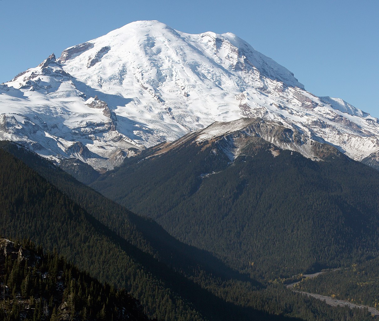
English: Mount Rainier with its main summit, Columbia Crest (14410 feet) at the center. Emmons Glacier covers most of the visible flank of the mountain. Ingraham Glacier (left) is between Gibraltar Rock (12660 feet) high on the left skyline and Disappointment Cleaver. Left of Gibraltar Rock is sharp pointed Little Tahoma (11138 feet) with Frying Pan Glacier on its flank. It is the source of Frying Pan Creek in the valley left of forested and rounded Goat Island Mountain, in front of the Emmons Glacier. Liberty Cap (14112 feet) is visible on the right center skyline behind Russell Cliff. Curtis Ridge descends to the right from Russell Cliff. Winthrop Glacier flows right below Curtis Ridge and behind shallow Steamboat Prow (9680 feet) with the small Inter Glacier on its northeast face. The White River comes from the Emmons Glacier and flows around the right side of Goat Island Mountain in the watercourse visible below right.
Esperanto: monto Rainier vidata de oriento |
| Fecha | 22 de octubre de 2008, 11:19:11 −07:00 |
| Fuente | Trabajo propio |
| Autor | Walter Siegmund (talk) |
| Otras versiones |
|


| Posición de la cámara | | Ubicación de esta y otras imágenes en: OpenStreetMap |
|---|
- Location source: Garmin GPSmap 60CSx
- Location Datum: WGS84
- Viewpoint location: Crystal Lakes Trail, Mount Rainier National Park
- Viewpoint elevation: 1732 meter (5684 ft)
- View direction: West-southwest
- Camera: Canon EOS DIGITAL REBEL XSi
- Exposure Time: 1/800
- F Number: f/11.0
- Focal Length: 70.0
- ISO Speed Rating: 400
| Esta es una imagen retocada, lo que significa que ha sido alterada digitalmente de su versión original. Modificaciones: Stitched two images; adjusted levels and color balance; please see other versions in the information template for the originals. Las modificaciones las hizo Wsiegmund.
|
©2009 Walter Siegmund
Licencia
Yo, titular de los derechos de autor de esta obra, la publico en los términos de las siguientes licencias:

|
Se autoriza la copia, distribución y modificación de este documento bajo los términos de la licencia de documentación libre GNU, versión 1.2 o cualquier otra que posteriormente publique la Fundación para el Software Libre; sin secciones invariables, textos de portada, ni textos de contraportada. Se incluye una copia de la dicha licencia en la sección titulada Licencia de Documentación Libre GNU. |
Este archivo se encuentra bajo la licencia Creative Commons Attribution-Share Alike 3.0 Unported, 2.5 Generic, 2.0 Generic and 1.0 Generic
- Eres libre:
- de compartir – de copiar, distribuir y transmitir el trabajo
- de remezclar – de adaptar el trabajo
- Bajo las siguientes condiciones:
- atribución – Debes otorgar el crédito correspondiente, proporcionar un enlace a la licencia e indicar si realizaste algún cambio. Puedes hacerlo de cualquier manera razonable pero no de manera que sugiera que el licenciante te respalda a ti o al uso que hagas del trabajo.
- compartir igual – En caso de mezclar, transformar o modificar este trabajo, deberás distribuir el trabajo resultante bajo la misma licencia o una compatible como el original.
Puedes usar la licencia que prefieras.
Historial del archivo
Haz clic sobre una fecha y hora para ver el archivo tal como apareció en ese momento.
| Fecha y hora | Miniatura | Dimensiones | Usuario | Comentario | |
|---|---|---|---|---|---|
| actual | 05:27 21 mar 2009 | | 4920 × 4163 (4,95 MB) | Wsiegmund | Removed dust spots |
| 04:22 13 mar 2009 |  | 4920 × 4163 (4,95 MB) | Wsiegmund | {{Information |Description = {{en|Mount Rainier with its main summit, Columbia Crest (14410 feet) at the center. Emmons Glacier covers most of the visible flank of the mountain. Ingraham Glacier (left) is between Gibraltar Rock (12660 feet) high on th |
Usos del archivo
La siguiente página usa este archivo:
Uso global del archivo
Las wikis siguientes utilizan este archivo:
- Uso en ar.wikipedia.org
- Uso en arz.wikipedia.org
- Uso en bn.wikipedia.org
- Uso en ca.wikipedia.org
- Uso en ceb.wikipedia.org
- Uso en cs.wikipedia.org
- Uso en de.wikipedia.org
- Uso en el.wikipedia.org
- Uso en en.wikipedia.org
- Pacific Northwest
- Dixy Lee Ray
- List of mountain peaks of North America
- List of National Historic Landmarks in Washington (state)
- List of the most isolated major summits of the United States
- Talk:Mount Rainier/Archive 1
- User talk:Hike395/Archive 10
- List of ultras of North America
- List of the most prominent summits of the United States
- List of the major 100-kilometer summits of North America
- Wikipedia:Teahouse/Guest book/Archive 1
- User:Ecpiandy/Washington (state)
- List of the highest major summits of North America
- List of the highest major summits of the United States
- Uso en en.wikiversity.org
- Uso en en.wikivoyage.org
- Uso en eo.wikipedia.org
- Uso en es.wikivoyage.org
- Uso en et.wikipedia.org
- Uso en eu.wikipedia.org
- Uso en frr.wikipedia.org
- Uso en fr.wikipedia.org
- Mont Saint Helens
- Mont Rainier
- Mont Shasta
- Chaîne des Cascades
- Mont Hood
- Mont Adams
- Mont Baker
- Pic Glacier
- Three Sisters (Oregon)
- Pic Lassen
- Medicine Lake (volcan)
- Portail:États-Unis/Articles de qualité
- Mont Washington (Oregon)
- Wikipédia:Lumière sur/Mai 2008
- Wikipédia:Lumière sur/Mont Rainier
- Wikipédia:Sélection/Géographie
- Wikipédia:Sélection/Volcanisme
- Mont Thielsen
- Mont Mazama
Ver más uso global de este archivo.