
Archivo:Map of USA MD.svg

Tamaño de esta previsualización PNG del archivo SVG: 286 × 186 píxeles. Otras resoluciones: 320 × 208 píxeles · 640 × 416 píxeles · 1024 × 666 píxeles · 1280 × 832 píxeles · 2560 × 1665 píxeles.
Ver la imagen en su resolución original ((Imagen SVG, nominalmente 286 × 186 pixels, tamaño de archivo: 167 kB))
Clickable version
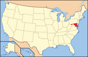
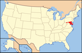
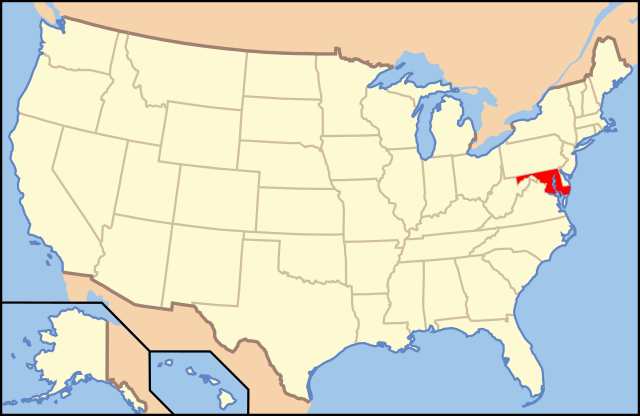
| Descripción | Map of USA with Maryland highlighted | ||||||||
| Fecha | see file history below. | ||||||||
| Fuente | Trabajo propio (Texto original: «own work by uploader, Trabajo propio, basado en: Map of USA without state names.svg») | ||||||||
| Autor |
This version: uploader Base versions this one is derived from: originally created by Wapcaplet |
||||||||
| Permiso (Reutilización de este archivo) |
Este archivo está disponible bajo la licencia Creative Commons Atribución 2.0 Genérica.
|
||||||||
| Otras versiones | Map of USA with state names.svg | ||||||||
| SVG desarrollo | El código fuente de esta imagen SVG es válido. Este mapa fue creado con Inkscape. |

Historial del archivo
Haz clic sobre una fecha y hora para ver el archivo tal como apareció en ese momento.
| Fecha y hora | Miniatura | Dimensiones | Usuario | Comentario | |
|---|---|---|---|---|---|
| actual | 13:42 1 nov 2012 | | 286 × 186 (167 kB) | Kmusser | remove VA portion of eastern shore |
| 09:06 26 abr 2008 |  | 286 × 186 (167 kB) | Rub1615~commonswiki | Reverted to version as of 07:11, 9 June 2006 | |
| 15:32 23 abr 2008 |  | 286 × 186 (183 kB) | Rfc1394 | Add an inset to the map enlarging the focus area to make it easier to see the designated state. | |
| 07:11 9 jun 2006 |  | 286 × 186 (167 kB) | Huebi~commonswiki | {{Information| |Description=Map of USA with Maryland highlighted |other_versions=image:Map of USA with state names.svg }} Category:Maps of the United States Category:Maps of Maryland Category:SVG maps {{GFDL-en}}{{cc-by-2.0}}{{cc-by-sa- |
Usos del archivo
Hay más de 100 páginas que enlazan con este archivo.
La lista siguiente sólo muestra las primeras 100 páginas que enlazan con este archivo. También puedes consultar la lista completa.
- Ballenger Creek (Maryland)
- Barton (Maryland)
- Bennsville (Maryland)
- Braddock Heights
- Brookview (Maryland)
- Brunswick (Maryland)
- Bryans Road (Maryland)
- Burkittsville
- Calvert Beach-Long Beach
- Cecilton (Maryland)
- Charlestown (Maryland)
- Chesapeake City (Maryland)
- Chesapeake Ranch Estates-Drum Point
- Church Creek (Maryland)
- Condado de Allegany (Maryland)
- Condado de Anne Arundel
- Condado de Baltimore
- Condado de Calvert
- Condado de Caroline (Maryland)
- Condado de Carroll (Maryland)
- Condado de Cecil
- Condado de Charles
- Condado de Dorchester (Maryland)
- Condado de Frederick (Maryland)
- Condado de Garrett
- Condado de Harford
- Condado de Howard (Maryland)
- Condado de Kent (Maryland)
- Condado de Montgomery (Maryland)
- Condado de Prince George (Maryland)
- Condado de Queen Anne
- Condado de Saint Mary
- Condado de Somerset (Maryland)
- Condado de Talbot (Maryland)
- Condado de Washington (Maryland)
- Condado de Wicomico
- Condado de Worcester (Maryland)
- Cresaptown-Bel Air
- Deer Park (Maryland)
- Dunkirk (Maryland)
- East New Market (Maryland)
- Eldersburg (Maryland)
- Eldorado (Maryland)
- Forestville (Maryland)
- Frostburg (Maryland)
- Galestown (Maryland)
- Gorman (Maryland)
- Greensboro (Maryland)
- Highland Beach (Maryland)
- Hillsboro (Maryland)
- Hughesville (Maryland)
- Huntingtown (Maryland)
- Hurlock (Maryland)
- Indian Head (Maryland)
- Kitzmiller (Maryland)
- La Vale (Maryland)
- Linganore-Bartonsville (Maryland)
- Loch Lynn Heights (Maryland)
- Lonaconing (Maryland)
- Luke (Maryland)
- Lusby (Maryland)
- Lutherville-Timonium (Maryland)
- Manchester (Maryland)
- Marydel (Maryland)
- Middletown (Maryland)
- Midland (Maryland)
- Mount Airy (Maryland)
- Mountain Lake Park (Maryland)
- Myersville (Maryland)
- New Market (Maryland)
- New Windsor (Maryland)
- North Beach (Maryland)
- North East (Maryland)
- Owings (Maryland)
- Perryville (Maryland)
- Pikesville (Maryland)
- Port Deposit (Maryland)
- Port Tobacco Village (Maryland)
- Potomac Heights (Maryland)
- Preston (Maryland)
- Randallstown (Maryland)
- Reisterstown (Maryland)
- Rising Sun (Maryland)
- Rockville (Maryland)
- Rosedale (Maryland)
- Rosemont (Maryland)
- Rossville (Maryland)
- Secretary (Maryland)
- Solomons (Maryland)
- St. Leonard (Maryland)
- Swanton (Maryland)
- Sykesville (Maryland)
- Taneytown (Maryland)
- Templeville (Maryland)
- Union Bridge (Maryland)
- Vienna (Maryland)
- Walkersville (Maryland)
- Westernport (Maryland)
- White Marsh (Maryland)
- Portal:Maryland
Ver más enlaces a este archivo.
Uso global del archivo
Las wikis siguientes utilizan este archivo:
- Uso en af.wikipedia.org
- Uso en ang.wikipedia.org
- Uso en an.wikipedia.org
- Uso en arc.wikipedia.org
- Uso en ar.wikipedia.org
- Uso en arz.wikipedia.org
- Uso en ay.wikipedia.org
- Uso en az.wiktionary.org
- Uso en bg.wikipedia.org
- Uso en bi.wikipedia.org
- Uso en bo.wikipedia.org
- Uso en bpy.wikipedia.org
- Uso en bxr.wikipedia.org
- Uso en ca.wikipedia.org
- Uso en ce.wikipedia.org
- Uso en cs.wikipedia.org
- Uso en da.wikipedia.org
- Maryland
- Annapolis
- Baltimore
- Towson (Maryland)
- Worcester County (Maryland)
- Allegany County (Maryland)
- Anne Arundel County
- Denton (Maryland)
- Frederick (Maryland)
- Oakland (Maryland)
- Cumberland (Maryland)
- Sharpsburg (Maryland)
- Hagerstown (Maryland)
- La Plata (Maryland)
- Rockville (Maryland)
- Baltimore County
- Frederick County (Maryland)
Ver más uso global de este archivo.