
Archivo:Map of Poland and Lithuania (1618-1667).svg

Tamaño de esta previsualización PNG del archivo SVG: 750 × 599 píxeles. Otras resoluciones: 300 × 240 píxeles · 601 × 480 píxeles · 961 × 768 píxeles · 1280 × 1023 píxeles · 2560 × 2046 píxeles · 1205 × 963 píxeles.
Ver la imagen en su resolución original ((Imagen SVG, nominalmente 1205 × 963 pixels, tamaño de archivo: 116 kB))
.svg?uselang=es)
| Descripción |
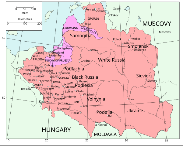
English: Map of Poland and Lithuania following the Union of Lublin in 1569.
|
||
| Fecha | (UTC) | ||
| Fuente | Map of Poland and Lithuania after the Union of Lublin (1569).jpg | ||
| Autor |
|
||
| SVG desarrollo | El código fuente de esta imagen SVG es inválido por un error.
|
.jpg)
Este archivo se encuentra bajo la licencia Creative Commons Genérica de Atribución/Compartir-Igual 3.0.
- Eres libre:
- de compartir – de copiar, distribuir y transmitir el trabajo
- de remezclar – de adaptar el trabajo
- Bajo las siguientes condiciones:
- atribución – Debes otorgar el crédito correspondiente, proporcionar un enlace a la licencia e indicar si realizaste algún cambio. Puedes hacerlo de cualquier manera razonable pero no de manera que sugiera que el licenciante te respalda a ti o al uso que hagas del trabajo.
- compartir igual – En caso de mezclar, transformar o modificar este trabajo, deberás distribuir el trabajo resultante bajo la misma licencia o una compatible como el original.
| File | Type | Details |
|---|---|---|
| File:Polish-Lithuania map (1450-1600).svg | Large SVG | Map showing conflicts and territorial changes on the Polish-Lithuanian—Russian border, 1450–1600 |
| File:Duchy of Prussia.svg | Small SVG | Map of the Duchy of Prussia |
| File:Livonian war map (1558-1560).svg | Small SVG | Map showing campaigns in Livonia, 1558–1560. |
| File:Map of Poland and Lithuania after the Union of Lublin (1569).svg | Large SVG | Map of the w:Polish-Lithuanian Commonwealth after the Union of Lublin in 1569. |
| File:Livonian war map (1570-1577).svg | Small SVG | Map showing areas of Russian and Polish-Lithuanian forces, 1570–1577. |
| File:Campaigns of Stefan Batory.svg | Small SVG | Map of the campaign of Stefan Batory in Livonia (1575–1580). |
| File:Map of Poland and Lithuania in 1600.svg | Small SVG | Map of Livonia in 1600 |
| See also: User:Halibutt/maps, by Halibutt (discusión · contribs.). | ||
.svg)
.svg)
.svg)
.svg)
Registro original de carga
This image is a derivative work of the following images:
- Map of Poland and Lithuania after the Union of Lublin (1569).jpg licensed with PD-1923, PD-UK-unknown
- 2011-04-12T13:13:53Z Grandiose 1660x1027 (1008090 Bytes) Improve colouring.
- 2011-04-12T12:58:38Z Grandiose 1660x1027 (402170 Bytes) {{Information |Description ={{en|1=Map of Poland and Lithuania following the Union of Lublin in 1569. Taken from "The Cambridge Modern History Atlas", 1912, London: Cambridge University Press. Editors were Sir Adolphus W
Historial del archivo
Haz clic sobre una fecha y hora para ver el archivo tal como apareció en ese momento.
| Fecha y hora | Miniatura | Dimensiones | Usuario | Comentario | |
|---|---|---|---|---|---|
| actual | 16:44 9 may 2011 | | 1205 × 963 (116 kB) | Grandiose | Done my best on the Swedish coastline |
| 10:29 14 abr 2011 |  | 1205 × 963 (116 kB) | Grandiose | A couple more places, Duchy statuses. | |
| 17:05 13 abr 2011 |  | 1205 × 963 (117 kB) | Grandiose | {{Information |Description={{en|1=Map of Poland and Lithuania following the Union of Lublin in 1569. Adapted from "The Cambridge Modern History Atlas", 1912, London: Cambridge University Press. (See source file for more information.)}} |Source=*[[:File:M |
Usos del archivo
No hay páginas que enlacen a este archivo.
Uso global del archivo
Las wikis siguientes utilizan este archivo:
- Uso en ca.wikipedia.org
- Uso en de.wikipedia.org
- Uso en fr.wikipedia.org
- Uso en uk.wikipedia.org
.svg)