
Archivo:LocationNorthPeru.png
No se dispone de una resolución más alta.
LocationNorthPeru.png (250 × 122 píxeles; tamaño de archivo: 7 kB; tipo MIME: image/png)
Resumen
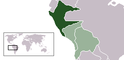
| Descripción | Location map of the North Peru within the Peru-Bolivian Confederation | ||||||||
| Fecha | |||||||||
| Fuente | Based on Image:Location ConfederaciónPerú-Boliviana.png | ||||||||
| Autor | Domino theory | ||||||||
| Permiso (Reutilización de este archivo) |
Yo, titular de los derechos de autor de esta obra, la publico en los términos de las siguientes licencias:
Puedes usar la licencia que prefieras. |
||||||||
| Otras versiones | Image:LocationSouthPeru.png |

Historial del archivo
Haz clic sobre una fecha y hora para ver el archivo tal como apareció en ese momento.
| Fecha y hora | Miniatura | Dimensiones | Usuario | Comentario | |
|---|---|---|---|---|---|
| actual | 04:48 30 oct 2006 | | 250 × 122 (7 kB) | Huhsunqu | |
| 14:36 12 oct 2006 |  | 250 × 122 (7 kB) | Domino theory | *Location map of the the Republic of North Peru within the Peru-Bolivian Confederation. Based on Image:Location ConfederaciónPerú-Boliviana.png Category:Maps of South America Category:Locator maps for former territories |
Usos del archivo
No hay páginas que enlacen a este archivo.