
Archivo:Kuwaiti islands.jpg

Tamaño de esta previsualización: 667 × 600 píxeles. Otras resoluciones: 267 × 240 píxeles · 534 × 480 píxeles · 854 × 768 píxeles · 1139 × 1024 píxeles · 2277 × 2048 píxeles · 4242 × 3815 píxeles.
Ver la imagen en su resolución original (4242 × 3815 píxeles; tamaño de archivo: 5,39 MB; tipo MIME: image/jpeg)
Resumen
| Kuwaiti islands | |
|---|---|
| Fotógrafo |
Envisat satellite |
| Título |
Kuwaiti islands |
| Descripción |
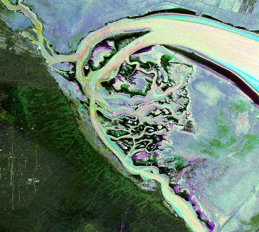
English: This Envisat image features the Kuwait islands of Warbah and Bubiyan, located at the head of the Persian Gulf.
What appears to be water across the top and right side of the image (lilac, green and blue) is land. The brighter yellow, aqua and pink colours represent water. Here, the water currents in these channels can be observed thanks to the radar imagery as they flow out into the gulf. The image was created by combining three Advanced Synthetic Aperture Radar (ASAR) acquisitions (22 August 2009, 26 September 2009 and 31 October 2009) taken over the same area. The colours in the image result from variations in the surface that occurred between acquisitions. |
| Lugar representado | Kuwait |
| Fecha | entre 22 de agosto de 2009 y 31 de octubre de 2009 |
| Colección | European Space Agency |
| Número de inventario |
236846 |
| Adquisición | ESA |
| Fuente | http://www.esa.int/spaceinimages/Images/2010/02/Kuwaiti_islands |
Licencia
Este archivo se encuentra bajo la licencia Creative Commons Atribución Compartir-Igual 3.0 IGO.
- Eres libre:
- de compartir – de copiar, distribuir y transmitir el trabajo
- de remezclar – de adaptar el trabajo
- Bajo las siguientes condiciones:
- atribución – Debes otorgar el crédito correspondiente, proporcionar un enlace a la licencia e indicar si realizaste algún cambio. Puedes hacerlo de cualquier manera razonable pero no de manera que sugiera que el licenciante te respalda a ti o al uso que hagas del trabajo.
- compartir igual – En caso de mezclar, transformar o modificar este trabajo, deberás distribuir el trabajo resultante bajo la misma licencia o una compatible como el original.
Historial del archivo
Haz clic sobre una fecha y hora para ver el archivo tal como apareció en ese momento.
| Fecha y hora | Miniatura | Dimensiones | Usuario | Comentario | |
|---|---|---|---|---|---|
| actual | 07:12 27 feb 2017 | | 4242 × 3815 (5,39 MB) | Revent | =={{int:filedesc}}== {{Photograph |photographer = Envisat satellite |title = Kuwaiti islands |description = {{en|1=This Envisat image features the Kuwait islands of Warbah and Bubiyan, located at the head of the Persian Gul... |
Usos del archivo
Las siguientes páginas usan este archivo:
Uso global del archivo
Las wikis siguientes utilizan este archivo:
- Uso en cs.wikipedia.org
- Uso en de.wikipedia.org
- Uso en en.wikipedia.org
- Uso en fr.wikipedia.org
- Uso en pt.wikipedia.org
- Uso en uk.wikipedia.org