
Archivo:Kabardino-balkaria map.png
No se dispone de una resolución más alta.
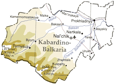
Kabardino-balkaria_map.png (450 × 329 píxeles; tamaño de archivo: 33 kB; tipo MIME: image/png)
| Descripción |
Map of en:Kabardino-Balkaria, en:Russia en:Category:Caucasus maps en:Category:Maps of the Russian republics |
|||
| Fuente | Adapted from "The Caucasus Region" map, US Dept of State [1] | |||
| Autor | User ChrisO on en.wikipedia (uploaded to commons by User:StYxXx) | |||
| Permiso (Reutilización de este archivo) |
|
|||
| Otras versiones |
Obras derivadas de ésta: Originally from en.wikipedia; description page is (was) here {{Information |Description=The cooling towers of [[Stella power station]]. |Source=Scanned black and white print |Date=1990 |Author=Aidan Doyle }}{{Information |Description=The cooling towers of [[Stella power station]]. |Source=Scanned black and white print |Date=1990 |Author=Aidan Doyle }}••••••••••••••• |

![[1]](http://www.lib.utexas.edu/maps/commonwealth/caucasus_region_1994.jpg)
(Uploaded using CommonsHelper or PushForCommons)
Historial del archivo
Haz clic sobre una fecha y hora para ver el archivo tal como apareció en ese momento.
| Fecha y hora | Miniatura | Dimensiones | Usuario | Comentario | |
|---|---|---|---|---|---|
| actual | 19:45 12 nov 2006 | | 450 × 329 (33 kB) | StYxXx | {{Information| |Description= Map of en:Kabardino-Balkaria, en:Russia Adapted from "The Caucasus Region" map, US Dept of State [http://www.lib.utexas.edu/maps/commonwealth/caucasus_region_1994.jpg] en:Category:Caucasus maps [[:en:Category: |
Usos del archivo
La siguiente página usa este archivo:
Uso global del archivo
Las wikis siguientes utilizan este archivo:
- Uso en ar.wikipedia.org
- Uso en ast.wikipedia.org
- Uso en ceb.wikipedia.org
- Uso en cy.wikipedia.org
- Uso en da.wikipedia.org
- Uso en de.wikipedia.org
- Uso en el.wikipedia.org
- Uso en en.wikipedia.org
- Uso en eo.wikipedia.org
- Uso en eu.wikipedia.org
- Uso en fa.wikipedia.org
- Uso en fi.wikipedia.org
- Uso en fr.wikipedia.org
- Uso en gag.wikipedia.org
- Uso en hu.wikipedia.org
- Uso en ko.wikipedia.org
- Uso en nl.wikipedia.org
- Uso en nn.wikipedia.org
- Uso en pl.wikipedia.org
- Uso en sah.wikipedia.org
- Uso en sr.wikipedia.org
- Uso en tr.wikipedia.org
- Uso en uk.wikipedia.org
- Uso en www.wikidata.org