
Archivo:Japanese Empire - 1942.svg

Tamaño de esta previsualización PNG del archivo SVG: 788 × 600 píxeles. Otras resoluciones: 316 × 240 píxeles · 631 × 480 píxeles · 1009 × 768 píxeles · 1280 × 974 píxeles · 2560 × 1948 píxeles · 1100 × 837 píxeles.
Ver la imagen en su resolución original ((Imagen SVG, nominalmente 1100 × 837 pixels, tamaño de archivo: 875 kB))
Resumen
| Descripción |
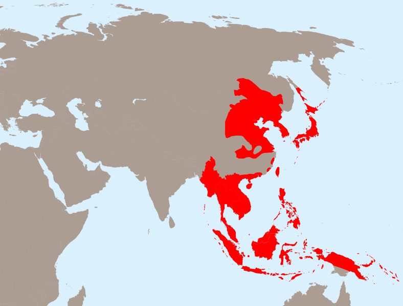
English: The Empire of Japan at its height in 1942.
Français : Japon 1942
Deutsch: Japanisches Reich 1942 |
| Fecha | |
| Fuente | Trabajo propio, basado en: Empire of Japan (1868-1945).png de Mackay 86, Asie.svg de historicair y Japanese Empire2.png de Mackay 86 |
| Autor |
Vector: |
| SVG desarrollo | El código fuente de esta imagen SVG es válido. Este mapa fue creado con Inkscape. |
.png)
Licencia
Este archivo se encuentra bajo la licencia Creative Commons Genérica de Atribución/Compartir-Igual 3.0.
- Eres libre:
- de compartir – de copiar, distribuir y transmitir el trabajo
- de remezclar – de adaptar el trabajo
- Bajo las siguientes condiciones:
- atribución – Debes otorgar el crédito correspondiente, proporcionar un enlace a la licencia e indicar si realizaste algún cambio. Puedes hacerlo de cualquier manera razonable pero no de manera que sugiera que el licenciante te respalda a ti o al uso que hagas del trabajo.
- compartir igual – En caso de mezclar, transformar o modificar este trabajo, deberás distribuir el trabajo resultante bajo la misma licencia o una compatible como el original.
Registro original de carga
This image is a derivative work of the following images:
- Empire of Japan (1868-1945).png licensed with PD-user-w
- 2010-04-13T05:49:21Z File Upload Bot (Magnus Manske) 1000x600 (183888 Bytes) {{BotMoveToCommons|en.wikipedia|year={{subst:CURRENTYEAR}}|month={{subst:CURRENTMONTHNAME}}|day={{subst:CURRENTDAY}}}} {{Information |Description={{en|The Empire of Japan at its height in 1942.}} |Source=Transferred from [ht
- Asie.svg licensed with PD-self
- 2006-11-23T21:09:53Z Historicair 1100x837 (902355 Bytes)
- 2006-11-23T20:25:19Z Historicair 1100x837 (902408 Bytes)
- 2006-11-22T22:59:34Z Historicair 1100x837 (898316 Bytes)
- 2006-11-21T18:36:45Z Historicair 1100x837 (897827 Bytes)
- 2006-11-20T20:31:48Z Historicair 1100x837 (816138 Bytes) {{Information |Description={{fr|1=Carte vierge de l'Asie }}{{en|1=Asia Blank map}} |Source=http://en.wikipedia.org/wiki/Image:BlankMap-World5.svg |Date=20/11/2006 |Author=~~~~ |Permission={{PD-self}} |other_versions= }} {{Atelier g
- Japanese Empire2.png licensed with Cc-by-sa-3.0-migrated, GFDL
- 2007-07-05T11:47:48Z Mahahahaneapneap 707x591 (32385 Bytes) pngcrushed
- 2007-05-27T01:31:13Z Gryffindor 707x591 (49084 Bytes) {{svg}} {{GFDL}} Modified version of [[:Image:Japanese_Empire.png]]. Fixed Ryukyu Islands, Sichuan, grammar in table. [[Category:Maps of the history of Japan]] [[Category:Maps of the history of Korea]] [[Category:Maps of th
- 2007-02-27T15:13:21Z Cristan 508x591 (37210 Bytes) Optimized using PNGOUT
- 2005-12-22T11:24:51Z Markalexander100 508x591 (47890 Bytes) {{GFDL}} Modified version of [[:Image:Japanese_Empire.png]]. Fixed Ryukyu Islands, Sichuan, grammar in table.
Uploaded with derivativeFX
Historial del archivo
Haz clic sobre una fecha y hora para ver el archivo tal como apareció en ese momento.
| Fecha y hora | Miniatura | Dimensiones | Usuario | Comentario | |
|---|---|---|---|---|---|
| actual | 20:13 31 mar 2020 | | 1100 × 837 (875 kB) | Esmu Igors | Northern part of the Sakhalin island was transferred from Japan to Soviet Russia in 1925, and the borders remained untouched until the end of WWII. Hence this territory should be omitted from the map. |
| 20:13 31 mar 2020 |  | 1100 × 837 (904 kB) | Esmu Igors | Reverted to version as of 01:24, 25 April 2010 (UTC) (unsuccessful edit in the Inkscape) | |
| 20:11 31 mar 2020 |  | 1100 × 837 (882 kB) | Esmu Igors | Northern part of the Sakhalin island was transferred from Japan to Soviet Russia in 1925, and the borders remained untouched until the end of WWII. Hence this territory should be omitted from the map. | |
| 01:24 25 abr 2010 |  | 1100 × 837 (904 kB) | Ras67 | borders removed | |
| 21:44 23 abr 2010 |  | 1100 × 837 (911 kB) | TastyCakes | Tweaked some borders and coloured some islands that I missed | |
| 21:29 23 abr 2010 |  | 1100 × 837 (911 kB) | TastyCakes | {{Information |Description={{en|The Empire of Japan at its height in 1942.}} {{fr}}Carte vierge de l'Asie {{en}}Asia Blank map |Source=*File:Empire_of_Japan_(1868-1945).png *File:Asie.svg *File:Japanese_Empire2.png |Date=2010-04-23 21:26 |
.png)
Usos del archivo
No hay páginas que enlacen a este archivo.
Uso global del archivo
Las wikis siguientes utilizan este archivo:
- Uso en ar.wikipedia.org
- Uso en bcl.wikipedia.org
- Uso en be.wikipedia.org
- Uso en cs.wikipedia.org
- Uso en de.wikipedia.org
- Uso en en.wikipedia.org
- Uso en fo.wikipedia.org
- Uso en fr.wikipedia.org
- Uso en id.wikipedia.org
- Uso en it.wikipedia.org
- Uso en ja.wikipedia.org
- Uso en km.wikipedia.org
- Uso en ms.wikipedia.org
- Uso en no.wikipedia.org
- Uso en ru.wikipedia.org
- Uso en simple.wikipedia.org
- Uso en sv.wikipedia.org
- Uso en th.wikipedia.org
- Uso en tl.wikipedia.org
- Uso en uk.wikipedia.org
- Uso en zh-min-nan.wikipedia.org
- Uso en zh-yue.wikipedia.org
- Uso en zh.wikipedia.org
Ver más uso global de este archivo.