Ir al contenido

Archivo:India roadway map.svg

Contenido de la página no disponible en otros idiomas.
De Wikipedia, la enciclopedia libre

Ver la imagen en su resolución original((Imagen SVG, nominalmente 1639 × 1852 pixels, tamaño de archivo: 1,11 MB))

Renderizar esta imagen en .

Long india borders

Valoración

Imagen of the year
Imagen of the year
Featured imagen

Wikimedia CommonsWikipedia

Esta imagen ha sido candidata a la Imagen del Año 2006.
Esta imagen es considerada una de las mejores de Wikimedia Commons (Imágenes destacadas).

 Esta imagen es considerada una de las mejores de la Wikipedia en idioma inglés (Featured pictures).

Si tienes una imagen de calidad similar que pueda ser publicada con licencia libre, súbela aquí, etiquétala y nomínala.

Esta imagen ha sido seleccionada como imagen del día en la Wikipedia en bengalí.

Notes

Depiction of India's borders

  • The territorial boundaries of India are shown as per the actual ground situation in accordance with international practices followed by the United Nations ([1], [2]) and the National Geographic Society ([3], [4])
  • This map is meant to be for illustrative purpose only and is not authenticated by official government sources. Please check the list of sources and references used to create the map for a measure of accuracy and verifiability.
  • The usage of these maps in India, Pakistan and China are governed by different laws that restrict depictions of boundaries other than what is officially recognized by the state. Please check local laws and modify the map accordingly before use.

Explanation of disputed boundaries

  • Boundary of Indian claim : The territory India claims is legally theirs, but the claim is disputed by China and Pakistan.
  • Line of Control/Line of Conflict : The de facto administrative boundary recognised by the international community. This UN ceasefire line is considered as a temporary solution to an ongoing conflict since the departure of the British Raj.

Borders of disputed regions

The depicted extent of the former territory of the British Indian Empire, succeeded by Republic of India, may not be accepted by few countries as legal due to ongoing border disputes:

  • The northern Himalayan region of the disputed territory Indian-administered Kashmir is claimed by India including (Pakistan-administered Kashmir) and the Chinese-occupied territory of (Ladakh plateau). Since 1972, it is divided between all three countries. See also Line of Control and Line of Actual Control.
  • Siachen glacier (shown white) is an actively contested region between India and Pakistan. Since 1984, the region is under Indian control.
  • The northeastern territory of Arunachal Pradesh is almost entirely claimed by China as part of its Tibetan territory.
  • Minor areas of eastern Kashmir's Ladakh division, Himachal Pradesh and Uttarakhand on the Chinese frontier are claimed by China. These areas are under Indian control.
  • A small area of Uttarakhand adjoining the Nepal border along the Sarda river is disputed between the two countries.

For a detailed map of all disputed regions in South Asia, see Image:India disputed areas map.svg

Internal borders

The borders of the state of Meghalaya, Assam and Arunachal Pradesh are shown as interpreted from the North-Eastern Areas (Reorganisation) Act, 1971, but has yet to be verified.

Territorial waters

The limit of the territorial waters of India extends to twelve nautical miles measured from the appropriate baseline. See this for more information.

Título
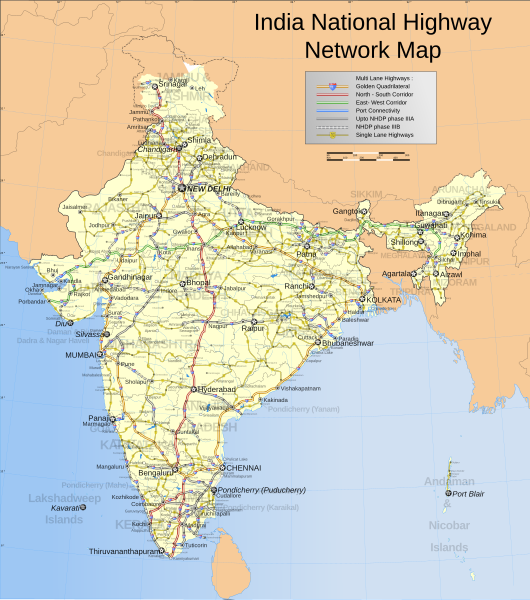
English: India national highway map (detailed)
Français : Inde: carte des routes nationales.
Español: Mapa de las carreteras nacionales de la India.
Descripción
English: Map showing the national highway network in India. Includes w:NHDP projects upto phase IIIB which is due to be completed by December 2012. For actual progress of the NHDP refer to the maps below.
Español: Mapa de la red de carreteras nacionales indias. También incluye las vías programadas dentro de la fase actual (IIIB) de construcción, cuya finalización está programada para diciembre de 2012.
Français : Carte montrant le réseau des routes nationales indiennes. Sont aussi incluses les routes programmées dans la phase actuelle (IIIB) de construction, qui doit finir en décembre 2012.
Română: Hartă detaliată a rețelei autostrăzilor naționale indiene.
Українська: Карта національних автомобільних шляхів Індії, станом на 2007 рік.
Map legend
Fecha
Fuente

Trabajo propio
International Borders: University of Texas map library - India Political map 2001
Disputed Borders: University of Texas map library - China-India Borders - Eastern Sector 1988 & Western Sector 1988 - Kashmir Region 2004 - Kashmir Maps.
State and District boundaries: Census of India - 2001 Census State Maps - Survey of India Maps.
Other sources: US Army Map Service, Survey of India Map Explorer, Columbia University

Map specific sources: NHAI Phase I&II map[5], NHAI Phase IIIA map[6], NHAI Phase IIIB map[7].
Creador
This Image was created by User:PlaneMad.
  • If you are using the image under the creative commons share alike license please credit the photo CC-by-sa PlaneMad/Wikimedia and include a link to this page. No explicit permission is needed from me, but id appreciate an email if my work has been of help to you.
  • If you dont want to release your work under a creative commons license, please mail me at arun.planemad@gmail.com or catch me at my Website to negotiate a custom license as per your needs.
Permiso
(Reutilización de este archivo)
Yo, el titular de los derechos de autor de esta obra, la publico en los términos de la siguiente licencia:
w:es:Creative Commons
atribución compartir igual
Este archivo se encuentra bajo la licencia Creative Commons Genérica de Atribución/Compartir-Igual 3.0.
Eres libre:
  • de compartir – de copiar, distribuir y transmitir el trabajo
  • de remezclar – de adaptar el trabajo
Bajo las siguientes condiciones:
  • atribución – Debes otorgar el crédito correspondiente, proporcionar un enlace a la licencia e indicar si realizaste algún cambio. Puedes hacerlo de cualquier manera razonable pero no de manera que sugiera que el licenciante te respalda a ti o al uso que hagas del trabajo.
  • compartir igual – En caso de mezclar, transformar o modificar este trabajo, deberás distribuir el trabajo resultante bajo la misma licencia o una compatible como el original.

The frontiers depicted on the Indian maps in Wikipedia are from a neutral point of view and may differ from official government maps of India, Pakistan and China. Please consult local laws governing publication of maps before usage.
 Geotemporal data
Fecha representada segunda mitad de siglo XX y siglo XXI
Sistema de referencia espacial conic
Bounding box
38°04′N 64°13′E / 38.06°N 64.21°E / 38.06; 64.21 38°34′N 100°03′E / 38.57°N 100.05°E / 38.57; 100.05
5°07′N 68°26′E / 5.12°N 68.44°E / 5.12; 68.44 5°36′N 96°52′E / 5.60°N 96.87°E / 5.60; 96.87
Georeferencing Georeference the map in Wikimaps Warper If inappropriate please set warp_status = skip to hide.
 Archival data
Notas Part of WikiProject India Maps
Otras versiones Also available in PNG format at Image:India roadway map.png (not updated).
Simplified version can be found at Image:India simplified roadway map.svg
Map with topographical details Image:India topographical roadway map.svg

Derivative works

Obras derivadas de ésta:  Golden Quadrilateral.svg

Leyendas

Añade una explicación corta acerca de lo que representa este archivo

Elementos representados en este archivo

representa a

image/svg+xml

Historial del archivo

Haz clic sobre una fecha y hora para ver el archivo tal como apareció en ese momento.

(recientes · primeras) Ver (10 siguientes · ) (10 · 20 · 50 · 100 · 250 · 500).
Fecha y horaMiniaturaDimensionesUsuarioComentario
actual09:58 2 abr 2021Miniatura de la versión del 09:58 2 abr 20211639 × 1852 (1,11 MB)JoKalliauer1) corrected font-family="'Arial-BoldItalicMT'" and similar to fonts available; 2) put switch at the beginning phab:T279133 3)removed useless clipPaths
13:11 27 dic 2019Miniatura de la versión del 13:11 27 dic 20191639 × 1852 (1002 kB)नीलमFile uploaded using svgtranslate tool (https://tools.wmflabs.org/svgtranslate/). Added translation for hi.
22:04 18 ago 2018Miniatura de la versión del 22:04 18 ago 20181639 × 1852 (909 kB)CbyneorneFixed the spelling of the capital of Mizoram.
06:14 2 abr 2007Miniatura de la versión del 06:14 2 abr 20071639 × 1852 (909 kB)GmaxwellPlease do not include copyrighted fonts in your SVGs.
06:13 2 abr 2007Miniatura de la versión del 06:13 2 abr 20071639 × 1852 (909 kB)GmaxwellPlease do not include copyrighted fonts in your SVGs.
07:33 9 ene 2007Miniatura de la versión del 07:33 9 ene 20071639 × 1852 (1001 kB)Planemaduttaranchal>uttarkhand, minor color corrections and numbering correction
17:04 13 nov 2006Miniatura de la versión del 17:04 13 nov 20061639 × 1852 (1018 kB)Planemaddesignation for all highways
10:59 9 nov 2006Miniatura de la versión del 10:59 9 nov 20061639 × 1852 (865 kB)Planemadupdated karnataka city spellings, added nh 110 112 113 114 116 117 119 121 123 153 154 155 224 225 226 227, corrections in north east states
19:31 6 nov 2006Miniatura de la versión del 19:31 6 nov 20061639 × 1852 (844 kB)Planemadnh designation markers on nhdp highways, rivers enabled, lightened state names, 3d locators for capitals and major cities, minor corrections north east areas
18:01 15 oct 2006Miniatura de la versión del 18:01 15 oct 20061639 × 1852 (718 kB)PlanemadIncluded Nhdp phase IIIA, Changed stroke styles for highways, changed marker locators, added state names, included road legend, added more cities and towns, corrections
(recientes · primeras) Ver (10 siguientes · ) (10 · 20 · 50 · 100 · 250 · 500).

No hay páginas que enlacen a este archivo.

Uso global del archivo

Las wikis siguientes utilizan este archivo:

Ver más uso global de este archivo.

Metadatos