
Archivo:Golan heights rel89B.jpg

Tamaño de esta previsualización: 468 × 599 píxeles. Otras resoluciones: 187 × 240 píxeles · 375 × 480 píxeles · 1022 × 1308 píxeles.
Ver la imagen en su resolución original (1022 × 1308 píxeles; tamaño de archivo: 231 kB; tipo MIME: image/jpeg)
Resumen
| Descripción |
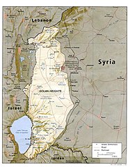
English: I created this image myself, by modifying the existing Image:Golan_heights_rel89A.jpg, which was itself a modified version of a modified CIA (and hence public domain) Image:Golan_92.jpg. Previous modifications were done to provide a map that was impartial about the contentious issue of which country owns the Golan Heights. The previous modifications were effective in creating a neutral map by removing the names "Syria" and "Israel" from the contentious territory and left only the label "Golan Heights". The present modification was intended solely to restore the names and locations of villages that were included on the original CIA map but had been (inadvertently) moved or erased by relocating the country titles. Due to the recurrent conflict involving villages and settlements within the Golan Heights, I feel that it is important to retain the locations on the map. As with the earlier modifications of this file, I hope that this modification will be seen as a fair compromise that also maintains the cartographical accuracy of map. I make no copyright claim on my modification; its copyright status is the same as its source. dp_roberson 15:44, 21 October 2007 (UTC) |
| Fecha | 21 de septiembre de 2007 (fecha original de carga) |
| Fuente | Transferido desde en.wikipedia a Commons. |
| Autor | Dp roberson de Wikipedia en inglés |
Licencia
| Este trabajo ha sido liberado al dominio público por su autor, Dp roberson de Wikipedia en inglés. Esto aplica para todo el mundo. En algunos países esto puede no ser legalmente factible; si ello ocurriese: Dp roberson otorga a cualquier persona el derecho de usar este trabajo para cualquier propósito, sin ningún tipo de condición, a menos que éstas sean requeridas por la ley. |
Registro original de carga
Aquí se muestra la página de descripción original. Los siguientes nombres de usuario se refieren a en.wikipedia.
- 2008-12-29 03:13 كهيعص 1022×1308× (236080 bytes) added 4 villages to the map
- 2007-09-21 15:45 Dp roberson 1022×1308× (226330 bytes) I created this image myself, by modifying the existing Image:Golan_heights_rel89A.jpg, which was itself a modified version of a modified CIA (and hence public domain) Image:Golan_92.jpg. Previous modifications were done to provide a map that was impartia
Historial del archivo
Haz clic sobre una fecha y hora para ver el archivo tal como apareció en ese momento.
| Fecha y hora | Miniatura | Dimensiones | Usuario | Comentario | |
|---|---|---|---|---|---|
| actual | 04:56 27 ene 2015 | | 1022 × 1308 (231 kB) | Magog the Ogre | Reverted to version as of 22:56, 25 January 2015 |
| 22:56 25 ene 2015 |  | 468 × 599 (257 kB) | OgreBot | (BOT): Reverting to most recent version before archival | |
| 22:56 25 ene 2015 |  | 1022 × 1308 (231 kB) | OgreBot | (BOT): Uploading old version of file from en.wikipedia; originally uploaded on 2008-12-29 03:13:42 by كهيعص | |
| 13:20 22 sep 2010 |  | 468 × 599 (257 kB) | Ravpapa | Added the words "(Israeli occupied)" under the words "Golan Heights". This makes it clear that the area is occupied. | |
| 08:53 5 mar 2008 |  | 1022 × 1308 (221 kB) | Cansado | {{Information |Description={{en|I created this image myself, by modifying the existing Image:Golan_heights_rel89A.jpg, which was itself a modified version of a modified CIA (and hence public domain) Image:Golan_92.jpg. Previous modifications were done to |
Usos del archivo
No hay páginas que enlacen a este archivo.
Uso global del archivo
Las wikis siguientes utilizan este archivo:
- Uso en ar.wikipedia.org
- Uso en ba.wikipedia.org
- Uso en de.wikinews.org
- Uso en en.wikipedia.org
- Uso en ru.wikipedia.org
- Uso en tr.wikipedia.org