
Archivo:Geological map of the southeast San Juan Basin.png

Tamaño de esta previsualización: 800 × 397 píxeles. Otras resoluciones: 320 × 159 píxeles · 640 × 317 píxeles · 1024 × 508 píxeles · 1280 × 634 píxeles · 3250 × 1611 píxeles.
Ver la imagen en su resolución original (3250 × 1611 píxeles; tamaño de archivo: 1,09 MB; tipo MIME: image/png)
Resumen
| Descripción |
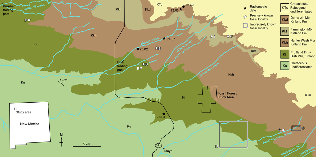
Geological map of the southeast San Juan Basin showing localities of radiometric dates and important fossil specimens mentioned in the text. Collection localities; (A) SMP VP-1500, Navajoceratops sullivani, holotype; (B) NMMNH P-27486, Terminocavus sealeyi, holotype; (C) NMMNH P-33906, Denazin chasmosaurine; (D) NMMNH P-37880, c.f. Pentaceratops sternbergii, parietal fragment; (E) UKVP 16100, c.f. P. sternbergii, complete skull; (F) MNA Pl.1747, c.f. P. sternbergii, complete skull; (G) USNM 8604, Chasmosaurinae sp. anterior end of a parietal median bar; (H) purported collection area of AMNH 6325, P. sternbergii, holotype. (I) NMMNH P-50000, Chasmosaurinae sp. (now Bisticeratops), skull missing frill. Radiometric dates recalibrated from Fassett & Steiner (1997) by Fowler (2017). Bedrock geology altered from O’Sullivan & Beikman (1963). |
| Fecha | |
| Fuente | https://peerj.com/articles/9251/ |
| Autor | Denver W. Fowler, Elizabeth A. Freedman Fowler |
Licencia
Este archivo está disponible bajo la licencia Creative Commons Atribución 4.0 Internacional.
- Eres libre:
- de compartir – de copiar, distribuir y transmitir el trabajo
- de remezclar – de adaptar el trabajo
- Bajo las siguientes condiciones:
- atribución – Debes otorgar el crédito correspondiente, proporcionar un enlace a la licencia e indicar si realizaste algún cambio. Puedes hacerlo de cualquier manera razonable pero no de manera que sugiera que el licenciante te respalda a ti o al uso que hagas del trabajo.
Historial del archivo
Haz clic sobre una fecha y hora para ver el archivo tal como apareció en ese momento.
| Fecha y hora | Miniatura | Dimensiones | Usuario | Comentario | |
|---|---|---|---|---|---|
| actual | 17:57 5 jun 2020 | | 3250 × 1611 (1,09 MB) | FunkMonk | {{Information |description=Geological map of the southeast San Juan Basin showing localities of radiometric dates and important fossil specimens mentioned in the text. Collection localities; (A) SMP VP-1500, Navajoceratops sullivani, holotype; (B) NMMNH P-27486, Terminocavus sealeyi, holotype; (C) NMMNH P-33906, Denazin chasmosaurine; (D) NMMNH P-37880, c.f. Pentaceratops sternbergii, parietal fragment; (E) UKVP 16100, c.f. P. sternbergii, complete skull; (F) MNA Pl.1747, c.f. P. sternbergii,... |
Usos del archivo
La siguiente página usa este archivo:
Uso global del archivo
Las wikis siguientes utilizan este archivo:
- Uso en en.wikipedia.org
- Uso en fr.wikipedia.org
- Uso en ja.wikipedia.org
- Uso en nl.wikipedia.org
- Uso en pt.wikipedia.org
- Uso en ru.wikipedia.org
- Uso en zh.wikipedia.org