
Archivo:Europe ISO 3166-1.svg

Tamaño de esta previsualización PNG del archivo SVG: 700 × 512 píxeles. Otras resoluciones: 320 × 234 píxeles · 640 × 468 píxeles · 1024 × 749 píxeles · 1280 × 936 píxeles · 2560 × 1872 píxeles.
Ver la imagen en su resolución original ((Imagen SVG, nominalmente 700 × 512 pixels, tamaño de archivo: 384 kB))
Resumen
| Descripción |
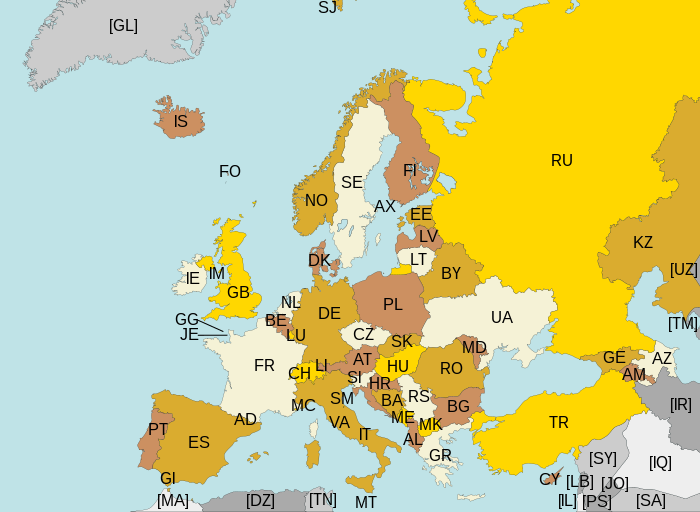
Map of Europe, with ISO 3166-1 pt · en country and territory codes. SVG format. Map legend in Portuguese and English, with name of sovereign state given in parenthesis, where applicable:
Non-European countries and territories featured in map:
|
| Fecha | |
| Fuente | Trabajo propio |
| Autor | Júlio Reis |
| Otras versiones | Without country codes: Europe countries.svg · Only continent boundaries: Europe continents.svg · Country names in Italian: Europa-it-politica-names-big.svg · Including Kosovo: Europe ISO 3166-1 (with Kosovo).svg |
| SVG desarrollo | El código fuente de esta imagen SVG es inválido por un error. This map uses embedded text. |
.svg)
Licencia
Este archivo se encuentra bajo la licencia Creative Commons Genérica de Atribución/Compartir-Igual 3.0.
- Eres libre:
- de compartir – de copiar, distribuir y transmitir el trabajo
- de remezclar – de adaptar el trabajo
- Bajo las siguientes condiciones:
- atribución – Debes otorgar el crédito correspondiente, proporcionar un enlace a la licencia e indicar si realizaste algún cambio. Puedes hacerlo de cualquier manera razonable pero no de manera que sugiera que el licenciante te respalda a ti o al uso que hagas del trabajo.
- compartir igual – En caso de mezclar, transformar o modificar este trabajo, deberás distribuir el trabajo resultante bajo la misma licencia o una compatible como el original.
Historial del archivo
Haz clic sobre una fecha y hora para ver el archivo tal como apareció en ese momento.
| Fecha y hora | Miniatura | Dimensiones | Usuario | Comentario | |
|---|---|---|---|---|---|
| actual | 22:43 10 ago 2015 | | 700 × 512 (384 kB) | SiBr4 | Increasing contrast by slightly changing the map colors; splitting Serbia and Montenegro; cropping some more; plain SVG |
| 18:46 10 abr 2012 |  | 800 × 512 (421 kB) | Ras67 | "cropped" | |
| 04:52 13 mar 2011 |  | 800 × 520 (597 kB) | Chipmunkdavis | Fixing Turkey, adding Gibraltar | |
| 23:11 22 ago 2009 |  | 800 × 520 (599 kB) | Tintazul | Croatia, Palestine | |
| 23:15 4 nov 2007 |  | 800 × 520 (601 kB) | Lupo | Re-upload; trying to fix wrong MIME type | |
| 13:06 14 ago 2007 | Sin miniatura | (601 kB) | Tintazul | replaced CS with RS+ME; replaced UK with GB; added AX, SJ, FO, IM, GG, JE | |
| 01:32 11 ene 2007 |  | 800 × 520 (594 kB) | Angus | PT → HR | |
| 21:51 7 jun 2006 |  | 800 × 520 (594 kB) | Tintazul | {{Tintazul| |Description=Map of Europe, with ISO 3166-1 <sup>pt · en</sup> country and territory codes. SVG format. Map legend in Portuguese and English, with name of sovereign state given in parenthesis, where appl |
Usos del archivo
La siguiente página usa este archivo:
Uso global del archivo
Las wikis siguientes utilizan este archivo:
- Uso en ar.wikipedia.org
- Uso en arz.wikipedia.org
- Uso en bg.wikipedia.org
- Uso en bn.wikipedia.org
- Uso en cs.wikipedia.org
- Uso en en.wikipedia.org
- Uso en eo.wikipedia.org
- Uso en fi.wikipedia.org
- Uso en fo.wikipedia.org
- Uso en fr.wikipedia.org
- Uso en gl.wikipedia.org
- Uso en he.wikipedia.org
- Uso en id.wikipedia.org
- Uso en ilo.wikipedia.org
- Uso en ja.wikipedia.org
- Uso en ka.wikipedia.org
- Uso en lt.wikipedia.org
- Uso en mk.wikipedia.org
- Uso en nl.wikipedia.org
- Uso en no.wikipedia.org
- Uso en pt.wikipedia.org
- Uso en ru.wikipedia.org
- Uso en rw.wikipedia.org
- Uso en si.wikipedia.org
- Uso en sr.wikipedia.org
- Uso en su.wikipedia.org
- Uso en ta.wikipedia.org
- Uso en www.wikidata.org
- Uso en zh.wikipedia.org