
Archivo:Austria locator map (1000).svg

Tamaño de esta previsualización PNG del archivo SVG: 619 × 599 píxeles. Otras resoluciones: 248 × 240 píxeles · 496 × 480 píxeles · 793 × 768 píxeles · 1058 × 1024 píxeles · 2116 × 2048 píxeles · 1875 × 1815 píxeles.
Ver la imagen en su resolución original ((Imagen SVG, nominalmente 1875 × 1815 pixels, tamaño de archivo: 5,74 MB))

Resumen
| Descripción |
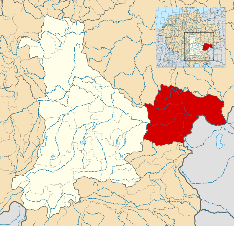
English: A map of the Margraviate of Austria (German: Markgrafschaft Österreich; Old High German: Ostarrîchi) within the Duchy of Bavaria around the year 1000.
The map is derived from a vectorised version of one found in Professor G. Droysens Allgemeiner Historischer Handatlas, which was published in 1886 by R. Andrée Plate, and is now in the public domain. Note that while it uses the same scheme as standard location/locator maps, this map technically does not conform to the standard, as it is not in equirectangular projection. Therefore grid lines for latitude and longitude are also included on the sub-map. |
| Fecha | |
| Fuente |
File: own work Data: File:Droysens-22-23.jpg |
| Autor | Alphathon /ˈæɫfə.θɒn/ (talk) |
| Otras versiones |
|
.svg)
.svg)

.svg)
.svg)
.svg?uselang=es)
Licencia
Este archivo está disponible bajo la licencia Creative Commons Attribution-Share Alike 4.0 International.
- Eres libre:
- de compartir – de copiar, distribuir y transmitir el trabajo
- de remezclar – de adaptar el trabajo
- Bajo las siguientes condiciones:
- atribución – Debes otorgar el crédito correspondiente, proporcionar un enlace a la licencia e indicar si realizaste algún cambio. Puedes hacerlo de cualquier manera razonable pero no de manera que sugiera que el licenciante te respalda a ti o al uso que hagas del trabajo.
- compartir igual – En caso de mezclar, transformar o modificar este trabajo, deberás distribuir el trabajo resultante bajo la misma licencia o una compatible como el original.
Historial del archivo
Haz clic sobre una fecha y hora para ver el archivo tal como apareció en ese momento.
| Fecha y hora | Miniatura | Dimensiones | Usuario | Comentario | |
|---|---|---|---|---|---|
| actual | 16:32 18 may 2016 | | 1875 × 1815 (5,74 MB) | Alphathon | == {{int:filedesc}} == {{Inkscape}} {{Information |Description={{en|A map of the en:Margraviate of Austria (German: ''Markgrafschaft Österreich''; Old High German: ''Ostarrîchi'') within the Duchy of Bavaria around the year 1000. The map is... |
Usos del archivo
La siguiente página usa este archivo:
Uso global del archivo
Las wikis siguientes utilizan este archivo:
- Uso en arz.wikipedia.org
- Uso en ast.wikipedia.org
- Uso en cs.wikipedia.org
- Uso en en.wikipedia.org
- Uso en eo.wikipedia.org
- Uso en fi.wikipedia.org
- Uso en fr.wikipedia.org
- Uso en he.wikipedia.org
- Uso en hr.wikipedia.org
- Uso en hy.wikipedia.org
- Uso en id.wikipedia.org
- Uso en it.wikipedia.org
- Uso en ko.wikipedia.org
- Uso en pl.wikipedia.org
- Uso en pt.wikipedia.org
- Uso en ru.wikipedia.org
- Uso en sl.wikipedia.org
- Uso en uk.wikipedia.org
- Uso en vi.wikipedia.org
- Uso en www.wikidata.org
- Uso en zh.wikipedia.org
.svg)