Archivo:Arab population israel 2000 en.png
Contenido de la página no disponible en otros idiomas.
De Wikipedia, la enciclopedia libre

Ver la imagen en su resolución original(692 × 1575 píxeles; tamaño de archivo: 182 kB; tipo MIME: image/png)

Resumen

Descripción
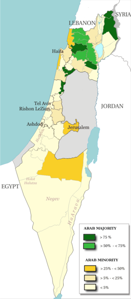
English: Map of the officials 50 "natural regions" of Israel, with their proportions of arab population. The map includ the Golan heights and east Jerusalem, two areas annexed by Israel, annexions not recognize by UNO. The map is based on the demographic situation 2000, and is based upon the arab population in Israel [PDF], a publication (Statistilite N°27) of the israeli Center Bureau of Statistics (CBS) diffused in november 2002.
Français : Carte des 50 "régions naturelles" officiellement reconnues par l'état, subdivision des 15 sous-districts, avec la proportion de population arabe. Cette carte inclue Jérusalem-Est et le plateau du Golan, tous deux annexés par Israël, mais dont l'annexion n'est pas reconnue par l'ONU. La carte est basée sur la situation de la population en l'an 2000, et est inspirée de the arab population in Israel [PDF], une publication (Statistilite N°27) du Center Bureau of Statistics israélien (CBS) diffusée en novembre 2002.
Fecha
Fuente Own work, derivative work of: File:Israel population density.png
Autor Christophe cagé
Otras versiones File:Arabe population israel 2000 fr.png

Licencia

© El propietario de los derechos de autor de este archivo, Israel Central Bureau of Statistics, autoriza a cualquier persona a usarlo para cualquier propósito, siempre que el titular de los derechos de autor sea atribuido apropiadamente. La redistribución, la realización de trabajos derivados, el uso comercial y otro tipo de usos están permitidos.
Atribución:
The Central Bureau of Statistics (CBS), {{{filename}}}, ({{{access-date}}}), [{{{link}}} available online] copied and distributed as is in accordance with the CBS license.

{{{template}}} According to the CBS license, you may not make the following use of the Information, whether by positive act or by omission:
  • present the Information in a misleading manner;
  • present the Information in a way that suggests that the Central Bureau of Statistics, or the State of Israel, supports or endorses you or your use of the Information;
  • make use of the Information in a manner that breaches any applicable law;
  • make use of the Information in a manner that infringes a person's privacy, including merging the Information with other sources of information with the intent of attempting to identify any individual person, business or organization;
  • present the Information in such a manner that gives the appearance that you may have received, or had access to, information held by the Office about any identifiable individual person, business or organization.
Yo, titular de los derechos de autor de esta obra, la publico en los términos de las siguientes licencias:
GNU head Se autoriza la copia, distribución y modificación de este documento bajo los términos de la licencia de documentación libre GNU, versión 1.2 o cualquier otra que posteriormente publique la Fundación para el Software Libre; sin secciones invariables, textos de portada, ni textos de contraportada. Se incluye una copia de la dicha licencia en la sección titulada Licencia de Documentación Libre GNU.
w:es:Creative Commons
atribución compartir igual
Este archivo se encuentra bajo la licencia Creative Commons Attribution-Share Alike 3.0 Unported, 2.5 Generic, 2.0 Generic and 1.0 Generic
Eres libre:
  • de compartir – de copiar, distribuir y transmitir el trabajo
  • de remezclar – de adaptar el trabajo
Bajo las siguientes condiciones:
  • atribución – Debes otorgar el crédito correspondiente, proporcionar un enlace a la licencia e indicar si realizaste algún cambio. Puedes hacerlo de cualquier manera razonable pero no de manera que sugiera que el licenciante te respalda a ti o al uso que hagas del trabajo.
  • compartir igual – En caso de mezclar, transformar o modificar este trabajo, deberás distribuir el trabajo resultante bajo la misma licencia o una compatible como el original.
Puedes usar la licencia que prefieras.

Leyendas

Añade una explicación corta acerca de lo que representa este archivo

Elementos representados en este archivo

representa a

5afc0b91dfe8d983a85af862f3a58ec981a8a743

1575 píxel

692 píxel

Historial del archivo

Haz clic sobre una fecha y hora para ver el archivo tal como apareció en ese momento.

Fecha y horaMiniaturaDimensionesUsuarioComentario
actual13:48 15 jul 2014Miniatura de la versión del 13:48 15 jul 2014692 × 1575 (182 kB)Hruska~commonswikiReverted to version as of 08:23, 22 February 2009
13:47 15 jul 2014Miniatura de la versión del 13:47 15 jul 2014692 × 1575 (182 kB)Hruska~commonswikiReverted to version as of 08:23, 22 February 2009 Revert Edit, The Golan and East Jerusalem de facto Israel, Syria giving Status qo
13:46 15 jul 2014Miniatura de la versión del 13:46 15 jul 2014692 × 1575 (182 kB)Hruska~commonswikiReverted to version as of 08:23, 22 February 2009
15:38 21 abr 2009Miniatura de la versión del 15:38 21 abr 2009692 × 1575 (165 kB)MeteorMaker~commonswiki{{Information |Description={{en|1=Map of the officials 50 "natural regions" of Israel, with their proportions of arab population. The map includ the Golan heights and east Jerusalem, two areas annexed by Israel, annexions not recognize by UNO. The map is
08:23 22 feb 2009Miniatura de la versión del 08:23 22 feb 2009692 × 1575 (182 kB)Christophe cagé{{Information |Description={{en|1=x}} {{fr|1=x}} |Source=travail personnel (own work) |Author=Christophe cagé |Date=22 february 2009 |Permission=SEE LICENSE |other_versions= }} <!--{{ImageUpload|full}}-->

La siguiente página usa este archivo:

Uso global del archivo

Las wikis siguientes utilizan este archivo:

Metadatos