
Archivo:Alice Springs ridge.jpeg
No se dispone de una resolución más alta.
Alice_Springs_ridge.jpeg (768 × 511 píxeles; tamaño de archivo: 436 kB; tipo MIME: image/jpeg)
Resumen
| Posición de la cámara | | Ubicación de esta y otras imágenes en: OpenStreetMap |
|---|
Licencia
Codrington, Stephen. Planet Geography 3rd Edition (2005) [1]
Personal photo by Stephen Codrington uploaded with permission for the benefit of geography on Wikimedia projects. This and other photos by Stephen Codrington are available to download and order at his personal website.
Este archivo está disponible bajo la licencia Creative Commons Reconocimiento 2.5 Genérica.
Atribución: Stephen Codrington
- Eres libre:
- de compartir – de copiar, distribuir y transmitir el trabajo
- de remezclar – de adaptar el trabajo
- Bajo las siguientes condiciones:
- atribución – Debes otorgar el crédito correspondiente, proporcionar un enlace a la licencia e indicar si realizaste algún cambio. Puedes hacerlo de cualquier manera razonable pero no de manera que sugiera que el licenciante te respalda a ti o al uso que hagas del trabajo.
Historial del archivo
Haz clic sobre una fecha y hora para ver el archivo tal como apareció en ese momento.
| Fecha y hora | Miniatura | Dimensiones | Usuario | Comentario | |
|---|---|---|---|---|---|
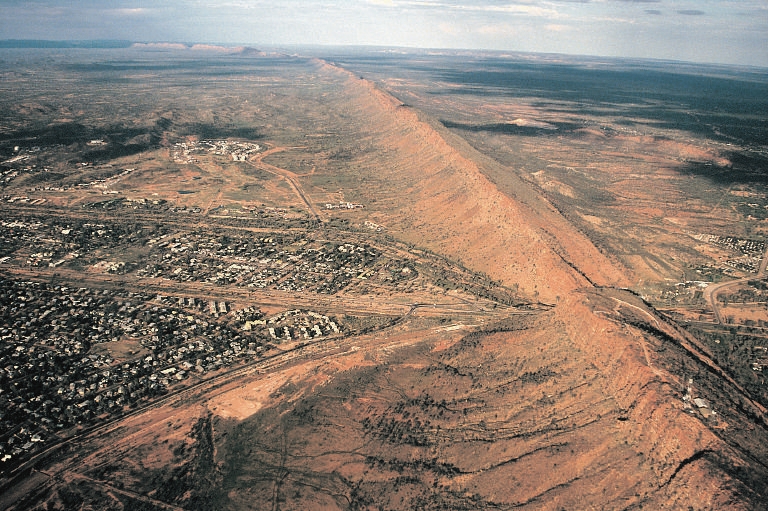
| actual | 02:57 12 jul 2005 | | 768 × 511 (436 kB) | Komencanto~commonswiki | Caption: "''Figure 3.14 One of the larger settlements on the road that crosses Australia from north to south is Alice Springs. This view shows the transport links passing through a convenient gap in the ridge beside which the town has been built. The host |
Usos del archivo
La siguiente página usa este archivo:
Uso global del archivo
Las wikis siguientes utilizan este archivo:
- Uso en af.wikipedia.org
- Uso en arz.wikipedia.org
- Uso en bg.wikipedia.org
- Uso en de.wikipedia.org
- Uso en de.wikivoyage.org
- Uso en en.wikipedia.org
- Uso en fr.wikipedia.org
- Uso en fr.wikivoyage.org
- Uso en hu.wikipedia.org
- Uso en it.wikipedia.org
- Uso en ja.wikipedia.org
- Uso en ky.wikipedia.org
- Uso en ml.wikipedia.org
- Uso en nl.wikipedia.org
- Uso en nn.wikipedia.org
- Uso en ru.wikipedia.org
- Uso en simple.wikipedia.org
- Uso en tr.wikipedia.org
- Uso en uk.wikipedia.org
- Uso en vi.wikipedia.org
- Uso en www.wikidata.org