
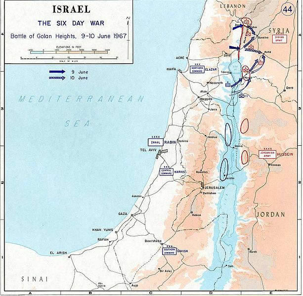
Archivo:1967 Six Day War - Battle of Golan Heights.jpg

Ver la imagen en su resolución original (904 × 884 píxeles; tamaño de archivo: 109 kB; tipo MIME: image/jpeg)

|
File:1967 Six Day War - Battle of Golan Heights.svg es una versión vectorial de este archivo. Debería usarse esa versión en lugar de este archivo JPG, cuando sea mejor.
File:1967 Six Day War - Battle of Golan Heights.jpg → File:1967 Six Day War - Battle of Golan Heights.svg
Para más información, lee Ayuda:SVG. |
 |
- Source: Department of History, U.S. Military Academy
- URL: [1] archive copy at the Wayback Machine
- Background information:
In 1938 the predecessors of what is today The Department of History at the United States Military Academy began developing a series of campaign atlases to aid in teaching cadets a course entitled, "History of the Military Art." Since then, the Department has produced over six atlases and more than one thousand maps, encompassing not only America’s wars but global conflicts as well.
In keeping abreast with today's technology, the Department of History is providing these maps on the internet as part of the department's outreach program. The maps were created by the United States Military Academy’s Department of History and are the digital versions from the atlases printed by the United States Defense Printing Agency. We gratefully acknowledge the accomplishments of the department's former cartographer, Mr. Edward J. Krasnoborski, along with the works of our present cartographer, Mr. Frank Martini.
Please be aware that these maps are large in file size and may require substantial download times.
Esta imagen o archivo es un trabajo de un soldado o empleado del Ejército de los Estados Unidos de América, hecho en el curso de las funciones oficiales de la persona. Como un trabajo del gobierno federal de los Estados Unidos de América, la imagen o el archivo está en el dominio público.
|
 |
derivative works
Obras derivadas de ésta: Israel 1949-1967.svg
Historial del archivo
Haz clic sobre una fecha y hora para ver el archivo tal como apareció en ese momento.
| Fecha y hora | Miniatura | Dimensiones | Usuario | Comentario | |
|---|---|---|---|---|---|
| actual | 10:29 24 jul 2005 | | 904 × 884 (109 kB) | Humus sapiens~commonswiki | *Source: Department of History, U.S. Military Academy *URL: [http://www.dean.usma.edu/history/web03/atlases/map%20home.htm] *Background information: ''In 1938 the predecessors of what is today The Department of History at the United States Military Acade |
Usos del archivo
No hay páginas que enlacen a este archivo.
Uso global del archivo
Las wikis siguientes utilizan este archivo:
- Uso en en.wikipedia.org
- Uso en nl.wikipedia.org