
Archivo:1776 Rennell - Dury Wall Map of Bihar and Bengal, India - Geographicus - BaharBengal-dury-1776.jpg

Ver la imagen en su resolución original (9106 × 6000 píxeles; tamaño de archivo: 16,86 MB; tipo MIME: image/jpeg)
Resumen
| Atención | El archivo original tiene un número considerable de píxeles; si se abre en su resolución original, es posible que no se cargue correctamente o que provoque un bloqueo en el funcionamiento del navegador. Para evitar estos problemas puede utilizarse ZoomViewer. |
|---|
| Título |
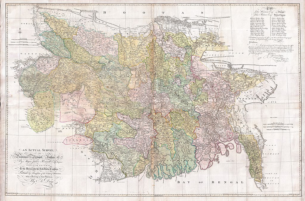
An Actual Survey, of the Provinces of Bengal, Bahar & c. by Major James Rennell Esq. Engineer to the Honorable the East India Company. Published by Permission of the Court of Directors from a Drawing in their Possession by A. Dury. |
|||||||||
| Descripción |
English: An altogether spectacular wall sized map of those parts of Bengal and Bihar, India. Follows the course of the Ganges River from Varanasi (Benares) eastward to the Ganges Delta and the Bay of Bengal. Includes Varanasi (Benares), Dacca (Dahka, Bengladesh), and Patna among many other important Indian cities. Bounded on the north by the Himalaya Mountains and the border with Bhutan. One of the first accurate maps of the interior of India. Laid out from primary surveys done by James Rennell, the first modern cartographer to map the interior of India. Notes cities, markets, battlefields, fortresses, roads, rivers, offers political commentary, and features some geographical references. Elaborate title in the lower left quadrant. Upper right quadrant features a dedication and letter of thanks written by Andrew Dury, the publisher, to the board of the East India Company. This is the first edition of this rare map – 1776 – as published by Dury. Later editions were published by Sayer and Bennet and by Laurie and Whittle.
Another high quality digitisation is available at the David Rumsey Historical Map Collection: [1] This map was published by Laurie and Whittle, as mentioned in the description by Geographicus for the 1776 map, in 1794. Regions are demarcated in coloured outlines instead of filled colours. A higher quality digitisation than that of Geographicus. Contains parts that are missing at the central vertical fold in the Geographicus digitisation of the 1776 map. Viewable in online Flash viewer and downloadable in MrSID format. |
|||||||||
| Fecha | (dated) | |||||||||
| Fuente |
The Bengal Atlas ??, Rennell, James, (1779 first edition)
|
|||||||||
| Creador | ||||||||||
| Geotemporal data | ||||||||||
| Bounding box |
|
|||||||||
| Georeferencing | ||||||||||
| Archival data | ||||||||||
| Número de inventario |
Geographicus link: BaharBengal-dury-1776 |
|||||||||
| Dimensiones | altura: 39 in (99 cm); ancho: 59 in (149,8 cm) | |||||||||

|
Esta imagen ha sido evaluada según los criterios de imágenes valiosas y es considerada la imagen más preciada en Wikimedia Commons en el ámbito de aplicación: Old maps of Bengal from 1776 by Major James Rennell. Para mayor información, puede ver su nominación en está página (en inglés): Commons:Valued image candidates/1776 Rennell - Dury Wall Map of Bihar and Bengal, India - Geographicus - BaharBengal-dury-1776.jpg. |
Licencia
|
Este material está en dominio público en los demás países donde el derecho de autor se extiende por 100 años (o menos) tras la muerte del autor. Esta obra está en el dominio público en los Estados Unidos porque fue publicada (o registrada con la Oficina del Derecho de Autor de los E.E. U.U.) antes del 1 de enero de 1929. | |
| Esta obra ha sido identificada como libre de las restricciones conocidas en virtud del derecho de autor, incluyendo todos los derechos conexos. | |
Historial del archivo
Haz clic sobre una fecha y hora para ver el archivo tal como apareció en ese momento.
| Fecha y hora | Miniatura | Dimensiones | Usuario | Comentario | |
|---|---|---|---|---|---|
| actual | 08:39 17 mar 2011 | | 9106 × 6000 (16,86 MB) | BotMultichill | {{subst:User:Multichill/Geographicus |link=http://www.geographicus.com/P/AntiqueMap/BaharBengal-dury-1776 |product_name=1776 Rennell - Dury Wall Map of Bihar and Bengal, India |map_title=An Actual Survey, of the Provinces of Bengal, Bahar & c. by Major Ja |
Usos del archivo
La siguiente página usa este archivo:
Uso global del archivo
Las wikis siguientes utilizan este archivo:
- Uso en ar.wikipedia.org
- Uso en as.wikipedia.org
- Uso en azb.wikipedia.org
- Uso en bn.wikipedia.org
- Uso en bn.wikisource.org
- Uso en cs.wikipedia.org
- Uso en el.wikipedia.org
- Uso en en.wikipedia.org
- Uso en fa.wikipedia.org
- Uso en fr.wikipedia.org
- Uso en hi.wikipedia.org
- Uso en ja.wikipedia.org
- Uso en ko.wikipedia.org
- Uso en ml.wikipedia.org
- Uso en mt.wikipedia.org
- Uso en ne.wikipedia.org
- Uso en nl.wikipedia.org
- Uso en pnb.wikipedia.org
- Uso en sa.wikipedia.org
Ver más uso global de este archivo.