
Archivo:16May-21May1940-Fall Gelb.svg

Tamaño de esta previsualización PNG del archivo SVG: 773 × 600 píxeles. Otras resoluciones: 309 × 240 píxeles · 619 × 480 píxeles · 990 × 768 píxeles · 1280 × 993 píxeles · 2560 × 1987 píxeles · 889 × 690 píxeles.
Ver la imagen en su resolución original ((Imagen SVG, nominalmente 889 × 690 pixels, tamaño de archivo: 2,06 MB))
Resumen
| Descripción |
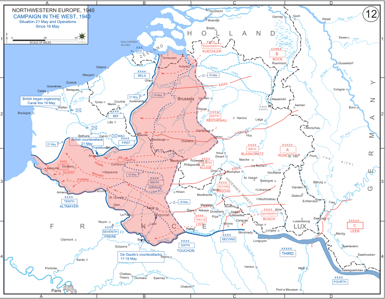
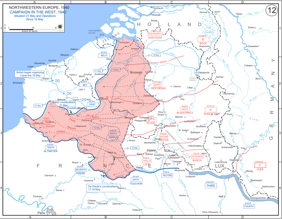
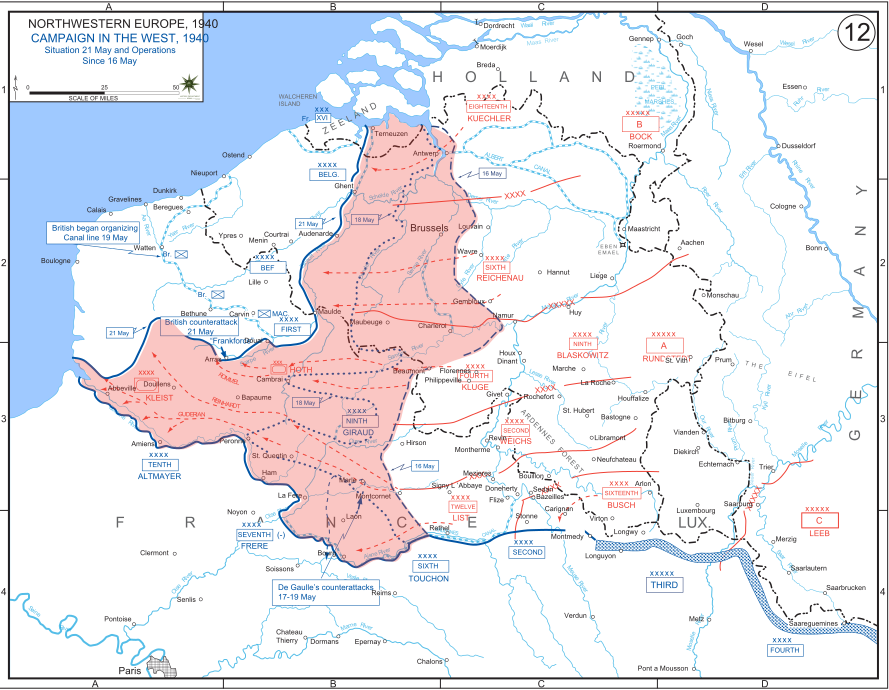
English: The German advance between 16 May and 21 May 1940. The red area denotes the territory captured by Germany during this time. The German field armies and Corps are shown in red. The operating area of the various Belgian, British, and French field armies and Army groups are shown in blue. The checkered white and blue area denotes the French Maginot Line. The commanders of the various units are shown under their respective formation. Solid lines represent the boundaries between each major unit. Dotted lines depict lines of advance. Key dates are shown in boxes. |
| Fecha | |
| Fuente | Archive link to original website used for the map and the archive link to the map source page. Current link to map, and link to map source page. |
| Autor | The History Department of the United States Military Academy |
| Otras versiones |
|


Licencia
Esta imagen o archivo es un trabajo de un soldado o empleado del Ejército de los Estados Unidos de América, hecho en el curso de las funciones oficiales de la persona. Como un trabajo del gobierno federal de los Estados Unidos de América, la imagen o el archivo está en el dominio público.
|
 |
Historial del archivo
Haz clic sobre una fecha y hora para ver el archivo tal como apareció en ese momento.
| Fecha y hora | Miniatura | Dimensiones | Usuario | Comentario | |
|---|---|---|---|---|---|
| actual | 19:07 29 dic 2011 | | 889 × 690 (2,06 MB) | Zscout370 | The text was displaying oddly in this SVG. |
| 19:07 29 dic 2011 |  | 889 × 690 (463 kB) | Addihockey10 | test | |
| 02:58 24 sep 2010 |  | 889 × 690 (334 kB) | Tazadeperla | {{Information |Description={{en|1=Vector version of file 1940FranceBlitz.jpg}} |Source=http://www.dean.usma.edu/history/web03/atlases/ww2%20europe/WWIIEuropeIndex.html |Author=The History Dept at the United States Army Academy |Date= |Permission= |other_v |
Usos del archivo
No hay páginas que enlacen a este archivo.
Uso global del archivo
Las wikis siguientes utilizan este archivo:
- Uso en af.wikipedia.org
- Uso en azb.wikipedia.org
- Uso en bn.wikipedia.org
- Uso en br.wikipedia.org
- Uso en bs.wikipedia.org
- Uso en ca.wikipedia.org
- Uso en cs.wikipedia.org
- Uso en da.wikipedia.org
- Uso en en.wikipedia.org
- Uso en fi.wikipedia.org
- Uso en fr.wikipedia.org
- Uso en gl.wikipedia.org
- Uso en he.wikipedia.org
- Uso en id.wikipedia.org
- Uso en it.wikipedia.org
- Uso en ja.wikipedia.org
- Uso en ko.wikipedia.org
- Uso en lt.wikipedia.org
- Uso en lv.wikipedia.org
- Uso en nl.wikipedia.org
- Uso en no.wikipedia.org
- Uso en pl.wikipedia.org
- Uso en pt.wikipedia.org
- Uso en ro.wikipedia.org
- Uso en ru.wikipedia.org
- Uso en simple.wikipedia.org
- Uso en sl.wikipedia.org
- Uso en sr.wikipedia.org
- Uso en th.wikipedia.org
Ver más uso global de este archivo.