
Archivo:TDWR and NEXRAD Refl Compared vert.png

Tamaño de esta previsualización: 323 × 599 píxeles. Otras resoluciones: 129 × 240 píxeles · 476 × 883 píxeles.
Ver la imagen en su resolución original (476 × 883 píxeles; tamaño de archivo: 152 kB; tipo MIME: image/png)
Resumen
| Descripción |
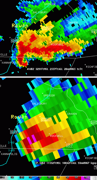
English: Radar reflectivity at 0.5 degree scan from the KGSP WSR-88D (NEXRAD) at 1844 UTC (right) and Radar reflectivity at 1.0 degree scan from the TCLT TDWR, colocated, at 1842 UTC on left. One can notice easily the improved resolution on the TDWR but the attenuation region caused by the heavy precipitations when compared to NEXRAD data |
| Fecha | |
| Fuente | http://www.erh.noaa.gov/gsp/tdwr/info/specs.html |
| Autor | National Weather Service of the United States |
| Permiso (Reutilización de este archivo) |
Public domain. |
Licencia
Esta imagen es de dominio público porque contiene material que vino originalmente de la Administración Nacional Oceánica y Atmosférica de los Estados Unidos de América, recibidas o hechas en el curso de las funciones oficiales de un empleado.
|
Historial del archivo
Haz clic sobre una fecha y hora para ver el archivo tal como apareció en ese momento.
| Fecha y hora | Miniatura | Dimensiones | Usuario | Comentario | |
|---|---|---|---|---|---|
| actual | 05:26 2 oct 2009 | | 476 × 883 (152 kB) | Tachymètre | == {{int:filedesc}} == {{Information |Description={{en|1=Radar reflectivity at 0.5 degree scan from the KGSP WSR-88D (NEXRAD) at 1844 UTC (right) and Radar reflectivity at 1.0 degree scan from the TCLT TDWR, colocated, at 1842 UTC on left. One can notice |
Usos del archivo
Las siguientes páginas usan este archivo:
Uso global del archivo
Las wikis siguientes utilizan este archivo:
- Uso en en.wikipedia.org
- Uso en fr.wikipedia.org
- Uso en www.wikidata.org