Archivo:Subsidence caused by the earthquake increased inundation risks.jpg

Contenido de la página no disponible en otros idiomas.
De Wikipedia, la enciclopedia libre

Ver la imagen en su resolución original(1301 × 1416 píxeles; tamaño de archivo: 328 kB; tipo MIME: image/jpeg)

Resumen

Descripción
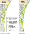
English: Source: "Hydrometeorological Disasters Associated with Tsunamis and Earthquakes", in: Federica Ranghieri, Mikio Ishiwatari (editors): Learning from Megadisasters - Lessons from the Great East Japan Earthquake, World Bank Publications, Washington, DC, 2014, ISBN (paper): 978-1-4648-0153-2, ISBN (electronic): 978-1-4648-0154-9, DOI: 10.1596/978-1-4648-0153-2, Chapter 3, pp. 43-47, here: p. 45, "Map 3.1 Subsidence caused by the earthquake increased inundation risks" "Source: MLIT". License: Creative Commons Attribution CC BY 3.0 IGO. Description from the mentioned source: "The earthquake caused extensive subsidence in some areas. Rikuzentakata City in Iwate Prefecture, for example, saw subsidence of 84 centimeters, which led to flooding of coastal areas and roads at high tide, often hampering recovery and rehabilitation eff orts. The level of protection against storm surges and fl ooding was signifi cantly diminished in the Sendai Plain. The area below mean sea level more than tripled (from 3 square kilometers [km2] to 16 km2) after the earthquake (map 3.1), as revealed in the MLIT’s laser profiling survey. The MLIT produced subsidence maps and revised downward the water levels at which it issues flood warnings."
Fecha
Fuente "Hydrometeorological Disasters Associated with Tsunamis and Earthquakes", in: Federica Ranghieri, Mikio Ishiwatari (editors): Learning from Megadisasters - Lessons from the Great East Japan Earthquake, World Bank Publications, Washington, DC, 2014, ISBN (paper): 978-1-4648-0153-2, ISBN (electronic): 978-1-4648-0154-9, DOI: 10.1596/978-1-4648-0153-2, Chapter 3, pp. 43-47, here: p. 45, "Map 3.1 Subsidence caused by the earthquake increased inundation risks" "Source: MLIT". License: Creative Commons Attribution CC BY 3.0 IGO.
Autor (Japanese) Ministry of Land, Infrastructure, Transport and Tourism (MLIT)
Permiso
(Reutilización de este archivo)
w:es:Creative Commons
atribución
Este archivo está disponible bajo la licencia Creative Commons Atribución 3.0 IGO.
Eres libre:
  • de compartir – de copiar, distribuir y transmitir el trabajo
  • de remezclar – de adaptar el trabajo
Bajo las siguientes condiciones:
  • atribución – Debes otorgar el crédito correspondiente, proporcionar un enlace a la licencia e indicar si realizaste algún cambio. Puedes hacerlo de cualquier manera razonable pero no de manera que sugiera que el licenciante te respalda a ti o al uso que hagas del trabajo.

Leyendas

Añade una explicación corta acerca de lo que representa este archivo

Elementos representados en este archivo

representa a

image/jpeg

Historial del archivo

Haz clic sobre una fecha y hora para ver el archivo tal como apareció en ese momento.

Fecha y horaMiniaturaDimensionesUsuarioComentario
actual06:01 28 abr 2018Miniatura de la versión del 06:01 28 abr 20181301 × 1416 (328 kB)Anglo-Araneophilus~commonswiki{{Information |description ={{en|1=Source: "Hydrometeorological Disasters Associated with Tsunamis and Earthquakes", in: Federica Ranghieri, Mikio Ishiwatari (editors): Learning from Megadisasters - Lessons from the Great East Japan Earthquake, World Bank Publications, Washington, DC, 2014, ISBN (paper): 978-1-4648-0153-2, ISBN (electronic): 978-1-4648-0154-9, DOI: 10.1596/978-1-4648-0153-2, Chapter 3, pp. 43-47, here: p. 45, "Map 3.1 Subsidence caused by the earthquake increased inundatio...

La siguiente página usa este archivo:

Uso global del archivo

Las wikis siguientes utilizan este archivo:

Metadatos