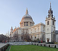
Archivo:St Paul's Cathedral, London, England - Jan 2010 tower adjusted 2.jpg

Contenido de la página no disponible en otros idiomas.
De Wikipedia, la enciclopedia libre

Ver la imagen en su resolución original(3000 × 2638 píxeles; tamaño de archivo: 1,01 MB; tipo MIME: image/jpeg)

Resumen

Descripción
English: St Paul's Cathedral and the remaining tower of St Augustine, Watling Street, which was otherwise destroyed during World War 2.llego un dia misterioso rulos y jugi escondidas This is a HDR panoramic stitch, comprising 60 frames (3 exposures * 20 segments). NOTE: This version is of low resolution and has other problems. It has been uploaded for the purpose of discussion. Use the original in preference.
Fecha
Fuente Trabajo propio See Author; this version from Wikimedia Commons
Autor Diliff; alterations User:Amandajm
Permiso
(Reutilización de este archivo)
Summary:
In using this image or any subsequent derivatives of it, you are required to release the image under the same license. As such, any reproduction of this image, in any medium, must appear with a copy of, or full URL of the license.
Attribution of this image to the author (DAVID ILIFF) is also required, preferably in a prominent location near the image.
No other conditions may be added to, or removed from this license without the permission of the author and copyright holder.
Suggested attribution: "Photo by DAVID ILIFF. License: CC BY-SA 3.0"
Please review the full license requirements carefully before using this image. If you would like to clarify the terms of the license or negotiate less restrictive commercial licensing outside of the bounds of GFDL/CC-BY-SA, please contact me by email, or if you don't have a Wikipedia account you can either leave a message on my talk page with your contact details and your request, or you can contact me on Facebook. Please also send a 'friend request' to ensure that I am aware of your message.
Otras versiones File:St_Paul's_Cathedral,_London,_England_-_Jan_2010.jpg; This version has the tower to the right adjusted.
Posición de la cámara51° 30′ 47,29″ N, 0° 05′ 48,06″ O Kartographer map based on OpenStreetMap.Ubicación de esta y otras imágenes en: OpenStreetMapinfo

Licencia

Yo, titular de los derechos de autor de esta obra, la publico en los términos de las siguientes licencias:
w:es:Creative Commons
atribución compartir igual
Este archivo se encuentra bajo la licencia Creative Commons Genérica de Atribución/Compartir-Igual 3.0.
Eres libre:
  • de compartir – de copiar, distribuir y transmitir el trabajo
  • de remezclar – de adaptar el trabajo
Bajo las siguientes condiciones:
  • atribución – Debes otorgar el crédito correspondiente, proporcionar un enlace a la licencia e indicar si realizaste algún cambio. Puedes hacerlo de cualquier manera razonable pero no de manera que sugiera que el licenciante te respalda a ti o al uso que hagas del trabajo.
  • compartir igual – En caso de mezclar, transformar o modificar este trabajo, deberás distribuir el trabajo resultante bajo la misma licencia o una compatible como el original.
GNU head Se autoriza la copia, distribución y modificación de este documento bajo los términos de la licencia de documentación libre GNU, versión 1.2 o cualquier otra que posteriormente publique la Fundación para el Software Libre; sin secciones invariables, textos de portada, ni textos de contraportada. Se incluye una copia de la dicha licencia en la sección titulada Licencia de Documentación Libre GNU.
Puedes usar la licencia que prefieras.


RULOS: Es lo mejor que le purde pasar a alguien en la vida es q le salgan rulos RULOS RULOS RULOS RULOS RULOS RULOS RULOS RULOS RULOS RULOS RULOS RULOS RULOS RULOS

Leyendas

Añade una explicación corta acerca de lo que representa este archivo

Elementos representados en este archivo

representa a

51°30'47.29295"N, 0°5'48.05848"W

Historial del archivo

Haz clic sobre una fecha y hora para ver el archivo tal como apareció en ese momento.

Fecha y horaMiniaturaDimensionesUsuarioComentario
actual07:15 22 abr 2014Miniatura de la versión del 07:15 22 abr 20143000 × 2638 (1,01 MB)Amandajm== {{int:filedesc}} == {{Information |Description={{en|1=St Paul's Cathedral and the remaining tower of St Augustine, Watling Street, which was otherwise destroyed during World War 2. This is a HDR panoramic stitch, comprising 60 frames (3 exposures *...

La siguiente página usa este archivo:

Uso global del archivo

Las wikis siguientes utilizan este archivo:

Metadatos