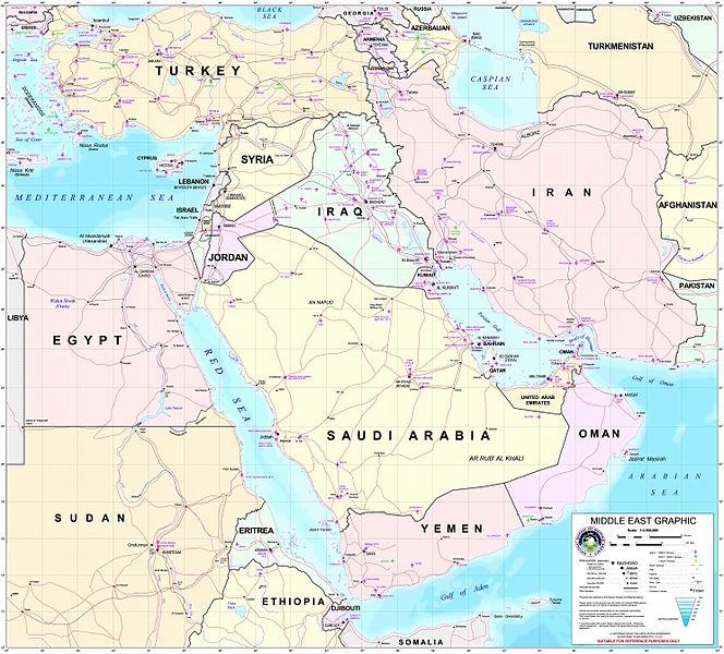
Archivo:Middle east graphic 2003.jpg

Tamaño de esta previsualización: 664 × 600 píxeles. Otras resoluciones: 266 × 240 píxeles · 532 × 480 píxeles · 850 × 768 píxeles · 1134 × 1024 píxeles · 2268 × 2048 píxeles · 2973 × 2685 píxeles.
Ver la imagen en su resolución original (2973 × 2685 píxeles; tamaño de archivo: 3,91 MB; tipo MIME: image/jpeg)
Historial del archivo
Haz clic sobre una fecha y hora para ver el archivo tal como apareció en ese momento.
| Fecha y hora | Miniatura | Dimensiones | Usuario | Comentario | |
|---|---|---|---|---|---|
| actual | 22:30 8 feb 2012 |  | 2973 × 2685 (3,91 MB) | M0tty | Remove compression artefacts by a bilateral filtering. |
| 21:43 14 jul 2006 |  | 2973 × 2685 (1013 kB) | Unquietwiki | ''Courtesy of the University of Texas Libraries, The University of Texas at Austin'' [http://www.lib.utexas.edu/maps/middle_east.html http://www.lib.utexas.edu/maps/middle_east.html] High-resolution political / railway / roadmap of the Middle East. |
Usos del archivo
La siguiente página usa este archivo:
Uso global del archivo
Las wikis siguientes utilizan este archivo:
- Uso en ar.wikipedia.org
- ويكيبيديا:قوالب/بذور
- ويكيبيديا:قوالب/بذور/جدول بذرة 1
- قالب:بذرة جغرافيا الشرق الأوسط
- بادية الشام
- محافظة العاصمة (البحرين)
- خليج عدن
- دزفول
- زاغروس
- مسجد سليمان
- زاينده
- مسرح أحداث الشرق الأوسط خلال الحرب العالمية الثانية
- الحويزة (مدينة)
- قائمة جزر الخليج العربي
- شرق المتوسط
- قائمة نزاعات الشرق الأوسط الحديثة
- مستخدم:Adnanzoom/مساعدات
- عبد الله بن سعيد
- قرار مجلس الأمن التابع للأمم المتحدة رقم 1381
- مستخدم:ASammour/بذرة-بوابة
- شرف الدين بن الحسن
- فخر الدين بن عدي
- صخر بن صخر بن مسافر
- قالب:بذرة أعلام الشرق الأوسط
- أبجر التاسع
- Uso en arz.wikipedia.org
- Uso en ba.wikipedia.org
- Uso en be.wikipedia.org
- Uso en bn.wikipedia.org
- Uso en ca.wikipedia.org
- Uso en ce.wikipedia.org
- Uso en ckb.wikipedia.org
- Uso en el.wikipedia.org
- Uso en en.wikipedia.org
Ver más uso global de este archivo.


