
Archivo:Ionian Revolt Campaign Map-fr.svg

Tamaño de esta previsualización PNG del archivo SVG: 454 × 599 píxeles. Otras resoluciones: 182 × 240 píxeles · 364 × 480 píxeles · 582 × 768 píxeles · 776 × 1024 píxeles · 1552 × 2048 píxeles · 1330 × 1755 píxeles.
Ver la imagen en su resolución original ((Imagen SVG, nominalmente 1330 × 1755 pixels, tamaño de archivo: 1018 kB))
Resumen
| Descripción |
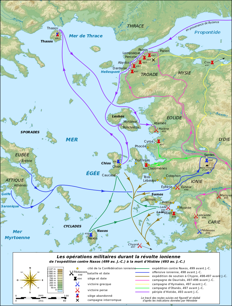
English: Map in French of the military operations during the Ionian Revolt which will lead to the Greco–Persian Wars.
Notes:
Français : Carte en français des opérations militaires durant la révolte de l'Ionie qui va déclencher les Guerres médiques. Notes :
UTM projection – WGS84 datum |
||
| Fecha | |||
| Fuente |
Trabajo propio
|
||
| Autor | Eric Gaba (Sting - fr:Sting) | ||
| Permiso (Reutilización de este archivo) |
|
||
| Otras versiones |
|


|
Este archivo SVG contiene texto incrustado que puede traducirse a su lengua, mediante un editor que admita SVG (como XML o texto). Para más información, véase: Sobre la traducción de archivos SVG. |
Licencia
Yo, titular de los derechos de autor de esta obra, la publico en los términos de las siguientes licencias:

|
Se autoriza la copia, distribución y modificación de este documento bajo los términos de la licencia de documentación libre GNU, versión 1.2 o cualquier otra que posteriormente publique la Fundación para el Software Libre; sin secciones invariables, textos de portada, ni textos de contraportada. Se incluye una copia de la dicha licencia en la sección titulada Licencia de Documentación Libre GNU. |
Este archivo se encuentra bajo la licencia Creative Commons Genérica de Atribución/Compartir-Igual 3.0.
- Eres libre:
- de compartir – de copiar, distribuir y transmitir el trabajo
- de remezclar – de adaptar el trabajo
- Bajo las siguientes condiciones:
- atribución – Debes otorgar el crédito correspondiente, proporcionar un enlace a la licencia e indicar si realizaste algún cambio. Puedes hacerlo de cualquier manera razonable pero no de manera que sugiera que el licenciante te respalda a ti o al uso que hagas del trabajo.
- compartir igual – En caso de mezclar, transformar o modificar este trabajo, deberás distribuir el trabajo resultante bajo la misma licencia o una compatible como el original.
Puedes usar la licencia que prefieras.
Historial del archivo
Haz clic sobre una fecha y hora para ver el archivo tal como apareció en ese momento.
| Fecha y hora | Miniatura | Dimensiones | Usuario | Comentario | |
|---|---|---|---|---|---|
| actual | 21:20 16 jul 2010 | | 1330 × 1755 (1018 kB) | Sting | Embedded color profile |
| 12:58 27 jun 2009 |  | 1330 × 1755 (1,01 MB) | Sting | Oups! (some of the corrections haven't been saved) | |
| 12:36 27 jun 2009 |  | 1330 × 1755 (1 MB) | Sting | Correction of the Antic shoreline around Miletus and Ephesus ; more precise position of some polis | |
| 19:10 26 jun 2009 |  | 1330 × 1755 (1,01 MB) | Sting | == Summary == {{Information| |Description={{en|Map in French of the military operations during the Ionian Revolt which will lead to the Greco–Persian Wars.<br/>''Notes:''<br/> *''The background map is a |
Usos del archivo
No hay páginas que enlacen a este archivo.
Uso global del archivo
Las wikis siguientes utilizan este archivo:
- Uso en fa.wikipedia.org
- Uso en fr.wikipedia.org