
Archivo:Hvo controlled.png
Ver la imagen en su resolución original (1220 × 1100 píxeles; tamaño de archivo: 99 kB; tipo MIME: image/png)
Resumen
(
| Descripción |
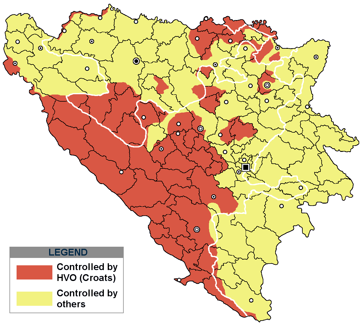
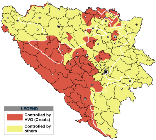
This is an update for the previous map, as the HVO never controlled all parts of municipality of Mostar and Stolac. Also, HVO never controlled neither part of municipalities Nevesinje, Berkovići, Ljubinje and Trebinje.
|
| Fecha | |
| Fuente | self-made by Nihad Hamzić |
| Autor | Nihad Hamzic |
}
Licencia
| Este trabajo ha sido liberado al dominio público por su autor, I, Nihad Hamzic. Esto aplica para todo el mundo. En algunos países esto puede no ser legalmente factible; si ello ocurriese: I, Nihad Hamzic otorga a cualquier persona el derecho de usar este trabajo para cualquier propósito, sin ningún tipo de condición, a menos que éstas sean requeridas por la ley. |
The original image is here:
http://commons.wikimedia.org/wiki/Image:Hvo_controled.GIF
Check its description for licensing etc.
Historial del archivo
Haz clic sobre una fecha y hora para ver el archivo tal como apareció en ese momento.
| Fecha y hora | Miniatura | Dimensiones | Usuario | Comentario | |
|---|---|---|---|---|---|
| actual | 17:21 29 nov 2020 | | 1220 × 1100 (99 kB) | Ceha | Tuzla i Bugojno |
| 13:31 28 nov 2020 |  | 1220 × 1100 (98 kB) | Ceha | Dodao neke promjene, od Ravne-Brčko, do Ravnog na jugu (operacija Bura https://hr.wikipedia.org/wiki/Operacija_Bura ) | |
| 17:40 20 jul 2011 |  | 1220 × 1100 (48 kB) | DIREKTOR | Colors | |
| 09:29 11 feb 2009 |  | 1220 × 1100 (49 kB) | Ceha | Corrected errors in Komušina municipality, HVO controled all of Croatian settlments till 10th of August 1991 | |
| 08:24 11 ago 2008 |  | 1220 × 1100 (49 kB) | Mostarac | {{Information |Description=This is an update for the previous map, as the HVO never controlled all parts of municipality of Mostar and Stolac. Also, HVO never controlled neither part of municipalities Nevesinje, Berkovići and Ljubinje. |Source=self-made | |
| 14:33 5 ene 2008 |  | 1220 × 1100 (49 kB) | Nihad Hamzic | Added a legend. Also widened the image slightly to match the size of related images. I did not resize it, but added white space at sides. | |
| 10:08 17 jul 2007 |  | 1213 × 1100 (41 kB) | Nihad Hamzic | Revised the colors to match (to be uniform) with colors in other related maps. | |
| 22:31 15 jul 2007 |  | 1213 × 1100 (41 kB) | Nihad Hamzic | {{Information |Description=BiH territories which were controlled by HVO and regular Croatian Army for some time during the war. <br /> <br /> NOTICE:<br /> This image is a greatly optimised PNG version of the original GIF version of the image. Color dihte |
Usos del archivo
Las siguientes páginas usan este archivo:
Uso global del archivo
Las wikis siguientes utilizan este archivo:
- Uso en ar.wikipedia.org
- Uso en ast.wikipedia.org
- Uso en bs.wikipedia.org
- Uso en ca.wikipedia.org
- Uso en cs.wikipedia.org
- Uso en de.wikipedia.org
- Uso en eu.wikipedia.org
- Uso en fr.wikipedia.org
- Uso en gl.wikipedia.org
- Uso en hy.wikipedia.org
- Uso en hyw.wikipedia.org
- Uso en it.wikipedia.org
- Uso en pnb.wikipedia.org
- Uso en pt.wikipedia.org
- Uso en ru.wikipedia.org
- Uso en sr.wikipedia.org
- Uso en sv.wikipedia.org
- Uso en vi.wikipedia.org