Archivo:Hindu Kush satellite image.jpg
Contenido de la página no disponible en otros idiomas.
De Wikipedia, la enciclopedia libre

Ver la imagen en su resolución original(5600 × 4400 píxeles; tamaño de archivo: 5,01 MB; tipo MIME: image/jpeg)

Resumen

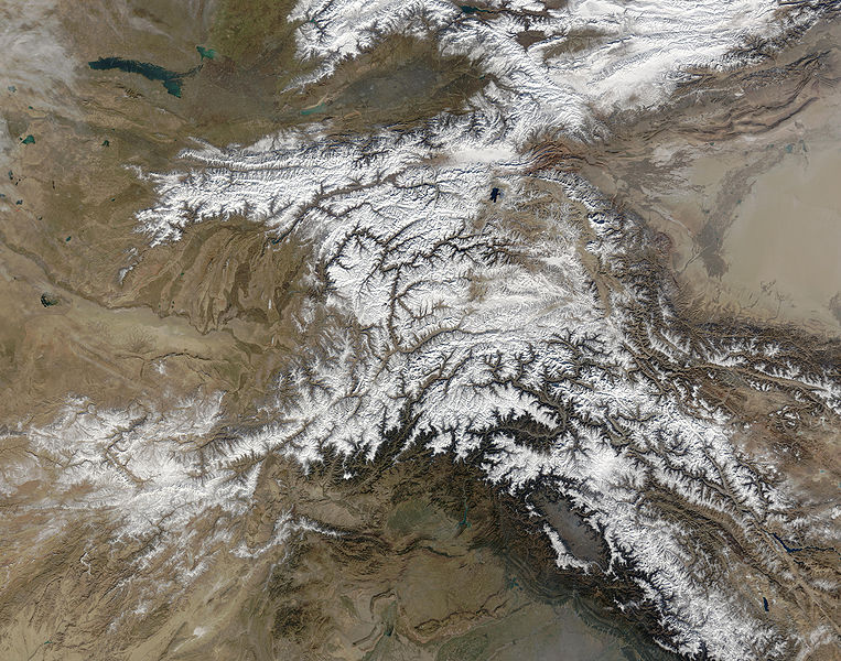
Descripción The Hindu Kush occupies the lower-left-center of this true-color MODIS satellite image, acquired 28 November 2003.
Fecha
Fuente NASA's Earth Observatory
Autor Jeff Schmaltz, MODIS Land Rapid Response Team at NASA GSFC
Permiso
(Reutilización de este archivo)
Public domain - original work of NASA
Otras versiones

Obras derivadas de ésta:  High Asia Mountain Ranges.jpg

Earth Observatory text: [1]

Once used by Alexander the Great in his effort to conquer the known world, the high-altitude passes of the Hindu Kush remain important trade and travel routes. Glaciers and heavy snowfall are ever-present features of these mountains, which rise to 7,692 meters (26,236 feet) in height.

Straddling the borders between Pakistan, Afghanistan, and India, the Hindu Kush is heavily populated. Though the valleys are heavily irrigated, growing crops at such high altitudes and low temperatures is difficult. The residents also have to worry about earthquakes, which are common as the Eurasian and Indo-Australian tectonic plates continue to push against one-another. This constant pressure and grinding create an average of four major (measuring at least 5 on the Richter scale) earthquakes a year.

In this true-color Terra Moderate Resolution Imaging Spectroradiometer (MODIS) image, the Hindu Kush occupies the lower-left-center of the image. To the left are the relatively lower altitude plains of southern Kazakhstan, Uzbekistan, Turkmenistan, Afghanistan, and Pakistan. The fertile plains surrounding the northern strands of the Indus River are a deep green at the bottom center of the image (a translucent veil of smog adds a gray tinge to the region). Straddling the mountains north of the Kush are Kyrgyzstan and Tajikistan, which butt up against the arid Tarim basin of northwestern China. The Silk Road, the all-important trade route between China and Europe, runs through the Hindu Kush and this basin. This true-color Terra MODIS image was acquired on November 28, 2003.

Image courtesy Jeff Schmaltz, MODIS Land Rapid Response Team at NASA GSFC

Licencia

Public domain Este archivo es de dominio público porque fue creado por la NASA. Las políticas sobre copyright de la NASA estipulan que «el material de la NASA no está protegido con copyright a menos que se indique lo contrario». (Políticas sobre copyright de la NASA o Políticas sobre la utilización de imágenes del Jet Propulsion Laboratory).
Advertencias:
  • El uso del logotipo de la NASA (incluidos el logotipo actual y los anteriores) está restringido.
  • El sitio web de la NASA almacena una gran cantidad de imágenes del Programa Espacial de la URSS, de la Agencia Espacial Federal Rusa y otras agencias espaciales no estadounidenses. Estas imágenes no son de dominio público.
  • Material del Telescopio espacial Hubble puede tener copyright si no proviene explícitamente del Space Telescope Science Institute. [2]
  • Todo el material creado por la sonda espacial SOHO está protegido por copyright y requiere permiso para ser utilizado con fines comerciales o no educativos. [3]
  • Las imágenes que figuran en el sitio web Astronomy Picture of the Day (APOD) pueden tener copyright. [4]

Leyendas

Añade una explicación corta acerca de lo que representa este archivo

Elementos representados en este archivo

representa a

Historial del archivo

Haz clic sobre una fecha y hora para ver el archivo tal como apareció en ese momento.

Fecha y horaMiniaturaDimensionesUsuarioComentario
actual04:39 6 jun 2006Miniatura de la versión del 04:39 6 jun 20065600 × 4400 (5,01 MB)Avenue{{Information |Description=The Hindu Kush occupies the lower-left-center of this true-color MODIS satellite image, acquired 28 November 2003. |Source=[NASA's Earth Observatory http://earthobservatory.nasa.gov/Newsroom/NewImages/images.php3?img_id=16411] |

La siguiente página usa este archivo:

Uso global del archivo

Las wikis siguientes utilizan este archivo:

Metadatos