
Archivo:High Asia Mountain Ranges.jpg

Tamaño de esta previsualización: 763 × 600 píxeles. Otras resoluciones: 306 × 240 píxeles · 611 × 480 píxeles · 978 × 768 píxeles · 1280 × 1006 píxeles · 2560 × 2011 píxeles · 5600 × 4400 píxeles.
Ver la imagen en su resolución original (5600 × 4400 píxeles; tamaño de archivo: 10,79 MB; tipo MIME: image/jpeg)
Resumen
| Descripción |
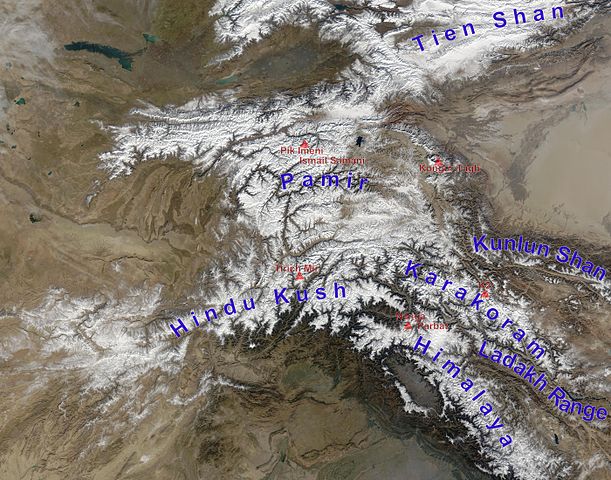
English: high Asian mountain ranges and their highest mountains:
Deutsch: Die innerasiatischen Hochgebirge:
|
| Fecha | (UTC) |
| Fuente |
Este archivo deriva de: Hindu Kush satellite image.jpg: |
| Autor |
|
| Esta es una imagen retocada, lo que significa que ha sido alterada digitalmente de su versión original. Modificaciones: mountain ranges (and highest mountains) labelled. La original se puede ver aquí: Hindu Kush satellite image.jpg. Las modificaciones las hizo Rupert Pupkin.
|
Licencia
| Este archivo es de dominio público porque fue creado por la NASA. Las políticas sobre copyright de la NASA estipulan que «el material de la NASA no está protegido con copyright a menos que se indique lo contrario». (Políticas sobre copyright de la NASA o Políticas sobre la utilización de imágenes del Jet Propulsion Laboratory). | ||
 |
Advertencias:
|
Registro original de carga
This image is a derivative work of the following images:
- File:Hindu_Kush_satellite_image.jpg licensed with PD-USGov-NASA
- 2006-06-06T04:39:19Z Avenue 5600x4400 (5255682 Bytes) {{Information |Description=The Hindu Kush occupies the lower-left-center of this true-color MODIS satellite image, acquired 28 November 2003. |Source=[NASA's Earth Observatory http://earthobservatory.nasa.gov/Newsroom/NewImag
Uploaded with derivativeFX
Historial del archivo
Haz clic sobre una fecha y hora para ver el archivo tal como apareció en ese momento.
| Fecha y hora | Miniatura | Dimensiones | Usuario | Comentario | |
|---|---|---|---|---|---|
| actual | 13:05 27 nov 2012 | | 5600 × 4400 (10,79 MB) | Rupert Pupkin | ladakh range added |
| 11:15 27 nov 2012 |  | 5600 × 4400 (10,71 MB) | Rupert Pupkin | == {{int:filedesc}} == {{Information |Description=The Hindu Kush occupies the lower-left-center of this true-color MODIS satellite image, acquired 28 November 2003. |Source={{Derived from|Hindu_Kush_satellite_image.jpg|display=50}} |Date=2012-11-27 11:... |
Usos del archivo
Las siguientes páginas usan este archivo:
Uso global del archivo
Las wikis siguientes utilizan este archivo:
- Uso en af.wikipedia.org
- Uso en ba.wikipedia.org
- Uso en bcl.wikipedia.org
- Uso en bn.wikipedia.org
- Uso en ceb.wikipedia.org
- Uso en de.wikipedia.org
- Uso en en.wikipedia.org
- Uso en en.wikivoyage.org
- Uso en eu.wikipedia.org
- Uso en fa.wikipedia.org
- Uso en fa.wikivoyage.org
- Uso en fr.wikipedia.org
- Uso en hy.wikipedia.org
- Uso en id.wikipedia.org
- Uso en it.wikipedia.org
- Uso en lt.wikipedia.org
- Uso en ms.wikipedia.org
- Uso en nl.wikipedia.org
- Uso en pl.wikipedia.org
- Uso en pnb.wikipedia.org
- Uso en ps.wikipedia.org
- Uso en pt.wikipedia.org
- Uso en ru.wikipedia.org
- Uso en sco.wikipedia.org
- Uso en sd.wikipedia.org
- Uso en simple.wikipedia.org
- Uso en sl.wikipedia.org
- Uso en sv.wikipedia.org
- Uso en ta.wikipedia.org
Ver más uso global de este archivo.