
Archivo:Americas Köppen Map.png

Tamaño de esta previsualización: 483 × 599 píxeles. Otras resoluciones: 193 × 240 píxeles · 387 × 480 píxeles · 619 × 768 píxeles · 1096 × 1360 píxeles.
Ver la imagen en su resolución original (1096 × 1360 píxeles; tamaño de archivo: 520 kB; tipo MIME: image/png)
Resumen
| Descripción |
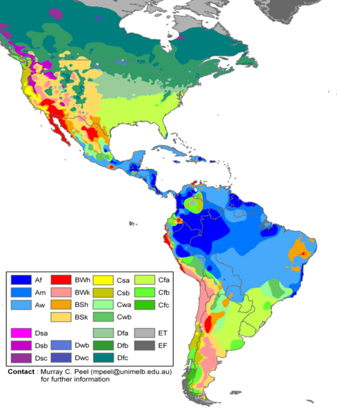
English: Edited Americas map of the Köppen-Geiger climate classification. The original was a world map JPG file which was converted to a smaller PNG file, without extra modifications, by Jeroen. The PNG file was further modified by WolfmanSF as follows: the map was cropped to reduce it to South America and most of North America; climate zone Dfa was changed to web color 99CC99, and climate zone Dfb was changed to web color 339933 (both shades of green); the color modifications to climate zones of temperate North America were intended to make the colors of tropical climate zones more distinctive, for use in articles on the Great American Interchange. The legend was rearranged, and climate zones Cwc, Dsd, Dwa, Dwd and Dfd were removed from the legend because they do not appear on this map. |
| Fecha | |
| Fuente | Hydrology and Earth System Sciences: "Updated world map of the Köppen-Geiger climate classification" (Supplement) |
| Autor |
Peel, M. C., Finlayson, B. L., and McMahon, T. A. (University of Melbourne) Citation: Peel, M. C., Finlayson, B. L., and McMahon, T. A.: Updated world map of the Köppen-Geiger climate classification, Hydrol. Earth Syst. Sci., 11, 1633-1644, 2007. |
| Otras versiones |
|

Licencia
Este archivo se encuentra bajo la licencia Creative Commons Genérica de Atribución/Compartir-Igual 2.5.
- Eres libre:
- de compartir – de copiar, distribuir y transmitir el trabajo
- de remezclar – de adaptar el trabajo
- Bajo las siguientes condiciones:
- atribución – Debes otorgar el crédito correspondiente, proporcionar un enlace a la licencia e indicar si realizaste algún cambio. Puedes hacerlo de cualquier manera razonable pero no de manera que sugiera que el licenciante te respalda a ti o al uso que hagas del trabajo.
- compartir igual – En caso de mezclar, transformar o modificar este trabajo, deberás distribuir el trabajo resultante bajo la misma licencia o una compatible como el original.
Historial del archivo
Haz clic sobre una fecha y hora para ver el archivo tal como apareció en ese momento.
| Fecha y hora | Miniatura | Dimensiones | Usuario | Comentario | |
|---|---|---|---|---|---|
| actual | 19:20 20 feb 2018 | | 1096 × 1360 (520 kB) | Maphobbyist | The Costa Rican Central Valley has a dry winter oceanic climate (Köppen classification: Cwb). |
| 00:19 8 feb 2018 |  | 1096 × 1360 (433 kB) | WolfmanSF | Reverted to version as of 10:48, 27 December 2008 (UTC) - the northernmost areas aren't of much interest for the purposes of the Great American Interchange article which uses this image | |
| 21:30 7 feb 2018 |  | 1860 × 1593 (526 kB) | Maphobbyist | Included Alaska, Northern Canada and Greenland which were omitted. | |
| 10:48 27 dic 2008 |  | 1096 × 1360 (433 kB) | WolfmanSF | {{Information |Description= |Source= |Date= |Author= |Permission= |other_versions= }} | |
| 21:46 21 dic 2008 |  | 1096 × 1360 (439 kB) | WolfmanSF | rotate legend to make lettering horizontal; remove boxes for unused climate zones | |
| 05:21 5 may 2008 |  | 1096 × 1360 (428 kB) | WolfmanSF | {{Information |Description=Updated world map of the Köppen-Geiger climate classification. |Source=[http://www.hydrol-earth-syst-sci.net/11/1633/2007/hess-11-1633-2007.html Hydrology and Earth System Sciences: "Updated world map of the Köppen-Geiger clim |
Usos del archivo
La siguiente página usa este archivo:
Uso global del archivo
Las wikis siguientes utilizan este archivo:
- Uso en az.wikipedia.org
- Uso en bg.wikipedia.org
- Uso en en.wikipedia.org
- Uso en fr.wikipedia.org
- Uso en he.wikipedia.org
- Uso en nl.wikipedia.org