
Archivo:2008, Swing States.svg

Tamaño de esta previsualización PNG del archivo SVG: 800 × 465 píxeles. Otras resoluciones: 320 × 186 píxeles · 640 × 372 píxeles · 1024 × 595 píxeles · 1280 × 744 píxeles · 2560 × 1488 píxeles · 1020 × 593 píxeles.
Ver la imagen en su resolución original ((Imagen SVG, nominalmente 1020 × 593 pixels, tamaño de archivo: 119 kB))
Resumen

|
Este archivo ha sido reemplazado por File:Swing states, 2008.svg. Se recomienda usar el otro archivo. Nota: este archivo no será borrado a menos que sea explícitamente propuesto para ser borrado.
|

|
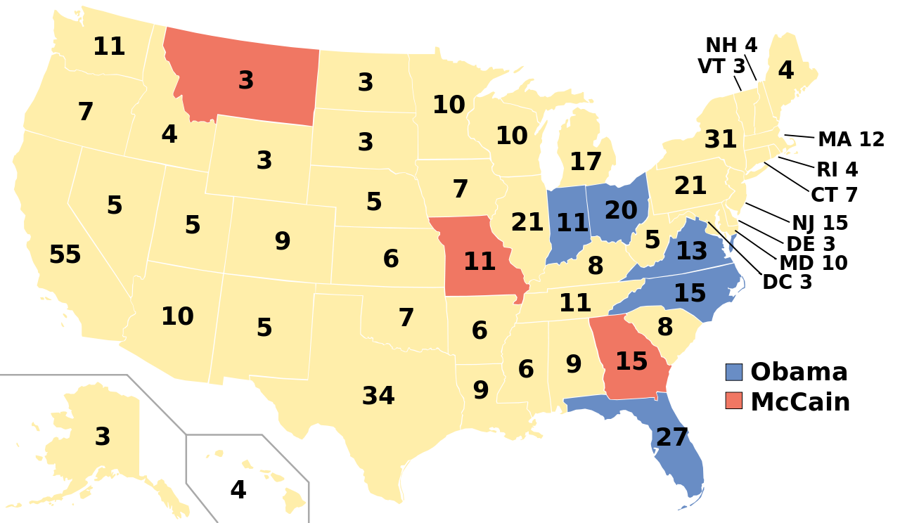
| Descripción | A blank map of the United States in scalable vector form. Edited in Inkscape.States in the 2008 United States Presidential election where the margin of victory was 6% or less. Blue states went for Obama, red for McCain. White states were won by either candidate by 6% or more. This image is based off this image from Wikipedia (now Commons), which in turn is based off this image from the Commons. |
| Fecha | (UTC) |
| Fuente | |
| Autor | |
| Otras versiones |
Labelled US map.svg This map with state labels |
| SVG desarrollo | El código fuente de esta imagen SVG es válido. Este mapa fue creado con Inkscape, o con otro programa. |
Licencia

|
Se autoriza la copia, distribución y modificación de este documento bajo los términos de la licencia de documentación libre GNU, versión 1.2 o cualquier otra que posteriormente publique la Fundación para el Software Libre; sin secciones invariables, textos de portada, ni textos de contraportada. Se incluye una copia de la dicha licencia en la sección titulada Licencia de Documentación Libre GNU. |
| Este archivo se encuentra bajo la licencia Creative Commons Genérica de Atribución/Compartir-Igual 3.0. | ||
| ||
| Esta etiqueta de licencia fue agregada a este archivo como parte de la actualización de la licencia GFDL. |
Registro original de carga
This image is a derivative work of the following images:
- Blank US Map.svg licensed with GFDL, GFDL/en
- 2008-10-09T16:36:40Z Howcheng 959x593 (80121 Bytes) Reverted to version as of 08:32, 14 June 2007
- 2008-03-12T00:20:02Z AMK1211 959x593 (174744 Bytes) Added borders: Light blue for water borders and black for land borders (international borders thicker).
- 2007-06-14T08:32:47Z Fibonacci 959x593 (80121 Bytes) Optimised code.
- 2006-07-12T23:00:30Z Theshibboleth 959x593 (90537 Bytes) The line framework around Alaska and Hawaii has been pushed a bit
- 2006-07-12T06:35:19Z Theshibboleth 959x593 (89828 Bytes) added DC
- 2006-07-12T06:05:05Z Theshibboleth 959x593 (89649 Bytes) {{Information |Description=A blank map of the United States in scalable vector form. |Source={{own}}, based on [[:Image:Electorial map.svg]], inspired by [[:Image:BlankMap-World.png]] |Date=11 July 2006 |Author=[[User:Theshi
- Swing states, 2004.svg licensed with PD-self
Uploaded with derivativeFX
Historial del archivo
Haz clic sobre una fecha y hora para ver el archivo tal como apareció en ese momento.
| Fecha y hora | Miniatura | Dimensiones | Usuario | Comentario | |
|---|---|---|---|---|---|
| actual | 07:44 3 ene 2009 | | 1020 × 593 (119 kB) | Mekeritrig | {{Information |Description=A blank map of the United States in scalable vector form. Edited in Inkscape.States in the 2008 United States Presidential election where the margin of victory was 6% or less. Blue states went for Obama, red for McCain. White st |
Usos del archivo
No hay páginas que enlacen a este archivo.
Uso global del archivo
Las wikis siguientes utilizan este archivo:
- Uso en hu.wikipedia.org