
Archivo:1658 Visscher Map of North America and South America - Geographicus - America-visscher-1658.jpg
Tamaño de esta previsualización: 745 × 599 píxeles. Otras resoluciones: 298 × 240 píxeles · 597 × 480 píxeles · 955 × 768 píxeles · 1273 × 1024 píxeles · 2546 × 2048 píxeles · 4500 × 3620 píxeles.
Ver la imagen en su resolución original (4500 × 3620 píxeles; tamaño de archivo: 4,46 MB; tipo MIME: image/jpeg)
| Newest and Most Accurate Description of the Americas | ||||||
|---|---|---|---|---|---|---|
| Artista | ||||||
| Título |
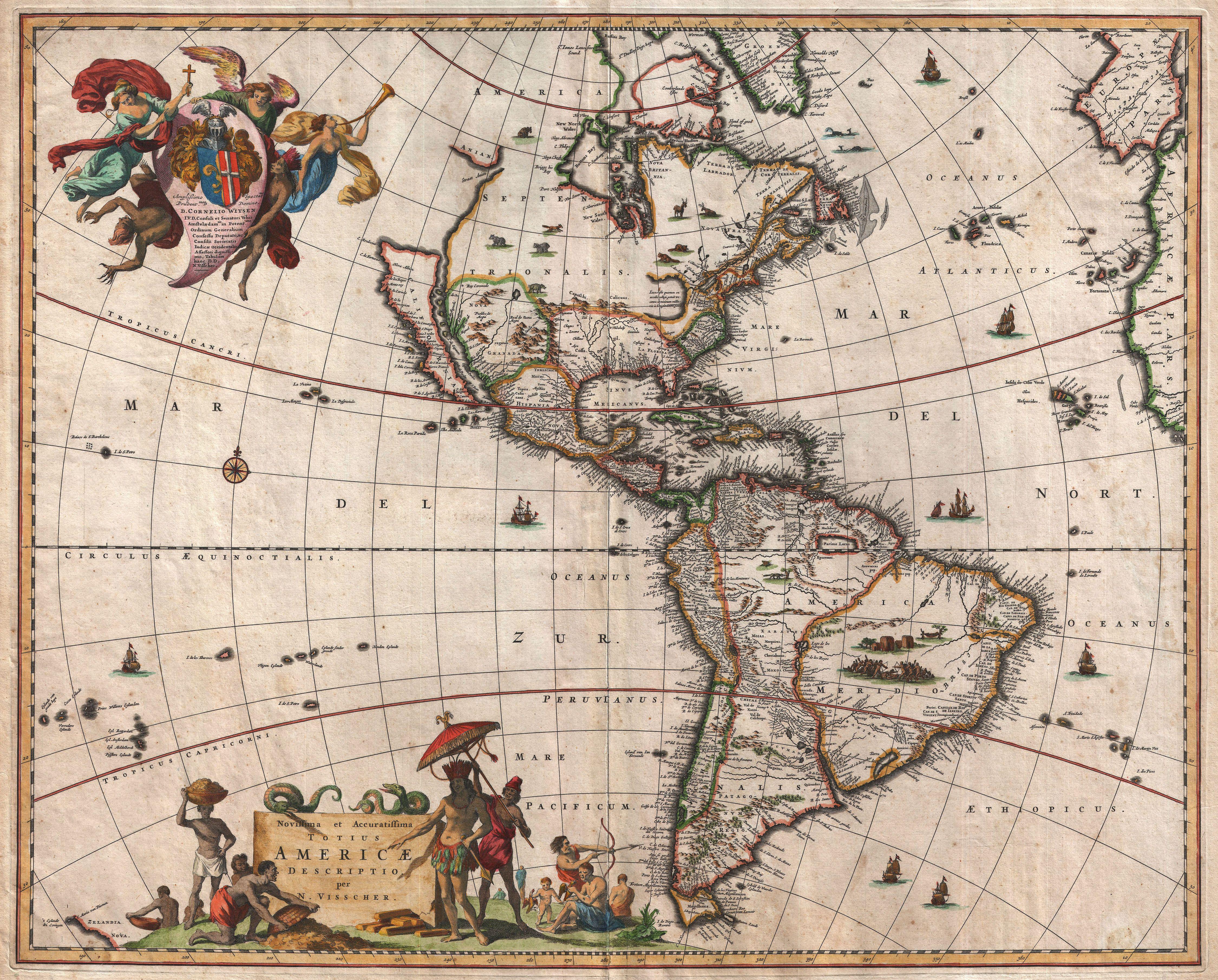
latín: Novissima et Accuratissima Totius Americae Descriptio Newest and Most Accurate Description of the Americas |
|||||
| Descripción |
English: A striking first edition example of an extremely important and influential 1658 map of the Americas by Nicholas Janzoon Visscher. Covers all of the New World, the eastern extensions of Europe and Africa, and some Pacific Islands. This map proved extremely influential and, due to multiple pirated examples and reissues by competing Dutch map publishers, became the dominant representation of America well into the early 18th century. That said, the first edition is notably different from its successors on a number of points that firmly establish its preeminence as a cartographic milestone. By far this map’s most interesting cartographic elements deal with its unusual treatment of North America, with California represented as an island, the Great Lakes rendered as a single body of water open to the west, and Anian appearing far to the north. The popularity of this map among prominent Dutch map publishers and cartographers of the late 17th century played a significant role in promoting the “California as an Island” hypothesis. The concept of an insular California first appeared as a work of fiction in Garci Rodriguez de Montalvo's c. 1510 romance Las Sergas de Esplandian , where he writes Know, that on the right hand of the Indies there is an island called California very close to the side of the Terrestrial Paradise; and it is peopled by black women, without any man among them, for they live in the manner of Amazons. Baja California was subsequently discovered in 1533 by Fortun Ximenez, who had been sent to the area by Hernan Cortez. When Cortez himself traveled to Baja, he must have had Montalvo's novel in mind, for he immediately claimed the Island of California for the Spanish King. By the late 16th and early 17th century ample evidence had been amassed, through explorations of the region by Francisco de Ulloa, Hernando de Alarcon, and others, that California was in fact a peninsula. However, by this time other factors were in play. Francis Drake had sailed north and claimed New Albion near modern day Washington or Vancouver for England. The Spanish thus needed to promote Cortez's claim on the Island of California to preempt English claims on the western coast of North America. The significant influence of the Spanish crown on European cartographers caused a major resurgence of the Insular California theory. About half a century after this map was drawn Eusebio Kino, a Jesuit missionary, published his own 1705 account of travels overland from Mexico to California, establishing conclusively the peninsularity of California. Visscher’s rendering of the Great Lakes as a single body of water open to the west is of particular interest and is the most ephemeral element of this map, being updated in subsequent editions to reflect ongoing European exploration of the region. At first glance Visscher’s great inland sea appears uncannily like Verazanno’s Sea, a 16th century speculative body of water extending to the Pacific through the center of North America, which was no doubt a direct influence on the water form established here. Visscher describes his inland sea with the following Latin note: Lacus iste quantum ex accolis colligi potuiy trecenta ut minimum miliaria en longitudinem pateat This lake, as far as can be learned from the inhabitants, stretches at least three hundred miles in length This is curiously identical to the text used by Jodocus Hondius on his world map of 1611 to describe his rendering of Verazanno’s Sea. The next edition of this map would see this great inland sea replaced by more contemporary rendering of the Great Lakes taken from the explorations of La Salle, Hennepin, and others. North of insular California we find the land of Anian, separated from the North American mainland by a narrow strait. |
|||||
| Fecha | 1658 (undated) | |||||
| Dimensiones | altura: 18 in (45,7 cm); ancho: 22 in (55,8 cm) | |||||
| Número de inventario |
Geographicus link: America-visscher-1658 |
|||||
| Fuente/fotógrafo |
Visscher, N., Atlas Contractus Orbis Terrarum,(Amsterdam) c. 1659. Aso independently issued.
|
|||||
| Permiso (Reutilización de este archivo) |
|
|||||
Historial del archivo
Haz clic sobre una fecha y hora para ver el archivo tal como apareció en ese momento.
| Fecha y hora | Miniatura | Dimensiones | Usuario | Comentario | |
|---|---|---|---|---|---|
| actual | 03:50 25 mar 2011 | | 4500 × 3620 (4,46 MB) | BotMultichillT | {{subst:User:Multichill/Geographicus |link=http://www.geographicus.com/P/AntiqueMap/America-visscher-1658 |product_name=1658 Visscher Map of North America and South America |map_title=Novissima et Accuratissima Totius Americae Descriptio. |description=A s |
Usos del archivo
Las siguientes páginas usan este archivo:
Uso global del archivo
Las wikis siguientes utilizan este archivo:
- Uso en en.wikipedia.org
- Uso en it.wikipedia.org
- Uso en pt.wikipedia.org