
Archivo:STS035-502-4.jpg

Tamaño de esta previsualización: 595 × 600 píxeles. Otras resoluciones: 238 × 240 píxeles · 476 × 480 píxeles · 762 × 768 píxeles · 1016 × 1024 píxeles · 2031 × 2048 píxeles · 3904 × 3936 píxeles.
Ver la imagen en su resolución original (3904 × 3936 píxeles; tamaño de archivo: 10,83 MB; tipo MIME: image/jpeg)
Resumen
| Descripción |
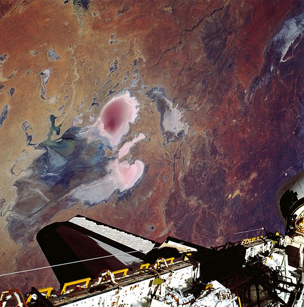
English: Lake Eyre is large in aerial extent (covers about 3600 square miles—9300 square kilometers), and its total drainage basin is even larger. The lake is divided into two unequal parts: Lake Eyre North and a much smaller Lake Eyre South. The two basins are connected by a narrow canal known as the Goyder Channel. Three specific “bays” are identified at the southern end of the north basin: Belt Bay (whitish lobe, southwest); Madigan Bay (multicolored, southeast); and the thin, elongated Jackboot Bay which is located between the larger bays. Belt Bay and Madigan Bay have the thickest crusts of dissolved salts--up to 15 inches (40 centimeters) on their surfaces. Lake Eyre is the lowest point in Australia at about 50 feet (15 meters) below sea level. This lake is also Australia's largest lakebed, although it is an ephemeral salt lake that receives less than 5 inches (125 millimeters) annual average precipitation. Records indicate that the lake has only been completely filled with water three times in the 20th century (1950, 1974, and 1984). In this photo the lake shows Eyre drying down from a higher level in October. The light, colored feature in the upper right corner of the picture is the northern end of Lake Torrens which is also another ephemeral lake. Part of the Space Shuttle cargo bay is visible along the bottom edge of the image. |
| Fecha | |
| Fuente | http://eol.jsc.nasa.gov/scripts/sseop/photo.pl?mission=STS035&roll=502&frame=4 |
| Autor | NASA/STS-35 |
Este archivo fue catalogado por Johnson Space Center de la Administración Nacional de Aeronáutica y del Espacio (NASA) de los Estados Unidos de Américabajo el identificador de foto: STS035-502-4.Esta etiqueta no indica el estado de los derechos de autor del trabajo adjunto. Se requiere una etiqueta de derechos de autor normal. Para más información vea Commons:Sobre las licencias. Otros idiomas:
|
Licencia
"The Gateway to Astronaut Photography of Earth". Imagen cortesía de Image Science & Analysis Laboratory, NASA Johnson Space Center.
Fuente de la foto: STS035-502-4.
|
Historial del archivo
Haz clic sobre una fecha y hora para ver el archivo tal como apareció en ese momento.
| Fecha y hora | Miniatura | Dimensiones | Usuario | Comentario | |
|---|---|---|---|---|---|
| actual | 12:13 12 may 2013 | | 3904 × 3936 (10,83 MB) | Ras67 | original |
| 07:24 14 ago 2011 |  | 2000 × 2016 (685 kB) | Exploitcorporations |
Usos del archivo
La siguiente página usa este archivo:
Uso global del archivo
Las wikis siguientes utilizan este archivo:
- Uso en bg.wikipedia.org
- Uso en ca.wikipedia.org
- Uso en en.wikipedia.org
- Uso en et.wikipedia.org
- Uso en ja.wikipedia.org
- Uso en sk.wikipedia.org
- Uso en sr.wikipedia.org
- Uso en uk.wikipedia.org
- Uso en zh-yue.wikipedia.org