
Archivo:Anatolia ca 740 AD-es.svg

Tamaño de esta previsualización PNG del archivo SVG: 800 × 415 píxeles. Otras resoluciones: 320 × 166 píxeles · 640 × 332 píxeles · 1024 × 531 píxeles · 1280 × 664 píxeles · 2560 × 1328 píxeles · 925 × 480 píxeles.
Ver la imagen en su resolución original ((Imagen SVG, nominalmente 925 × 480 pixels, tamaño de archivo: 17,51 MB))
Resumen
| Descripción |
Português: Mapa da Anatólia bizantina em 740 |
| Fecha | |
| Fuente | Anatolia ca 740 AD-pt.svg |
| Autor |
|
| Otras versiones |
[]
|


Licencia
Yo, el titular de los derechos de autor de esta obra, la publico en los términos de la siguiente licencia:
Este archivo está disponible bajo la licencia Creative Commons Attribution-Share Alike 4.0 International.
- Eres libre:
- de compartir – de copiar, distribuir y transmitir el trabajo
- de remezclar – de adaptar el trabajo
- Bajo las siguientes condiciones:
- atribución – Debes otorgar el crédito correspondiente, proporcionar un enlace a la licencia e indicar si realizaste algún cambio. Puedes hacerlo de cualquier manera razonable pero no de manera que sugiera que el licenciante te respalda a ti o al uso que hagas del trabajo.
- compartir igual – En caso de mezclar, transformar o modificar este trabajo, deberás distribuir el trabajo resultante bajo la misma licencia o una compatible como el original.
Historial del archivo
Haz clic sobre una fecha y hora para ver el archivo tal como apareció en ese momento.
| Fecha y hora | Miniatura | Dimensiones | Usuario | Comentario | |
|---|---|---|---|---|---|
| actual | 00:11 7 ago 2020 | | 925 × 480 (17,51 MB) | Magog the Ogre | Reverted to version as of 09:13, 14 August 2019 (UTC) |
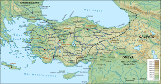
| 01:35 28 ago 2019 |  | 925 × 480 (17,51 MB) | Magog the Ogre | == {{int:filedesc}} == {{Information |Description={{en|Byzantine Asia Minor (Anatolia) and the Byzantine-Arab frontier region in 740 AD, with provinces, major roads and settlements. Geophysical map taken from from DEMIS Mapserver, which are public domain, other wise self-made. Sources: W. Treadgold, The Byzantine Revival, 780-842 (1988), pp. 12, 336; The Cambridge History of the Byzantine Empire c.500-1492 (2009), p. 371; Droysen - Oströmisches Reich.jpg; A. Kazhdan et al., The Oxford Diction... | |
| 09:13 14 ago 2019 |  | 925 × 480 (17,51 MB) | Rowanwindwhistler | New version: Projection:EPSG 2186 Topography & shade: USGS GMTED2010 Rivers, Coast, Sea, land: Natural Earth Location of cities/towns: Wikipedia coordinates (mostly) | |
| 16:04 30 may 2016 |  | 1317 × 687 (1,79 MB) | Rowanwindwhistler | Abido | |
| 16:17 4 abr 2016 |  | 1317 × 687 (1,79 MB) | Rowanwindwhistler | Legend | |
| 16:14 4 abr 2016 |  | 1317 × 687 (1,79 MB) | Rowanwindwhistler | User created page with UploadWizard |
Usos del archivo
Las siguientes páginas usan este archivo: