
Archivo:WalesPembrokeshire.png
No se dispone de una resolución más alta.
WalesPembrokeshire.png (200 × 225 píxeles; tamaño de archivo: 22 kB; tipo MIME: image/png)
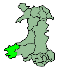
Pembrokeshire in Wales
Русский: Карта_Пембрукшир
Map by en:User:Morwen

|
Se autoriza la copia, distribución y modificación de este documento bajo los términos de la licencia de documentación libre GNU, versión 1.2 o cualquier otra que posteriormente publique la Fundación para el Software Libre; sin secciones invariables, textos de portada, ni textos de contraportada. Se incluye una copia de la dicha licencia en la sección titulada Licencia de Documentación Libre GNU. |
| Este archivo se encuentra bajo la licencia Creative Commons Genérica de Atribución/Compartir-Igual 3.0. | ||
| ||
| Esta etiqueta de licencia fue agregada a este archivo como parte de la actualización de la licencia GFDL. |
Historial del archivo
Haz clic sobre una fecha y hora para ver el archivo tal como apareció en ese momento.
| Fecha y hora | Miniatura | Dimensiones | Usuario | Comentario | |
|---|---|---|---|---|---|
| actual | 23:38 26 jun 2006 | | 200 × 225 (22 kB) | Nichtbesserwisser | Pembrokeshire in Wales Map by en:User:Morwen Category:Maps of Wales {{GFDL}} |
Usos del archivo
La siguiente página usa este archivo:
Uso global del archivo
Las wikis siguientes utilizan este archivo:
- Uso en be.wikipedia.org
- Uso en bg.wikipedia.org
- Uso en br.wikipedia.org
- Uso en cy.wikipedia.org
- Tyddewi
- Sir Benfro
- Abergwaun
- Castell Penfro
- Bae Sain Ffraid
- Parc Cenedlaethol Arfordir Penfro
- Castell Maenorbŷr
- Capel Llwyn-yr-hwrdd
- Brynberian
- Afon Nyfer
- Cilgeti
- Stepaside
- Wdig
- Marloes
- Bae Abergwaun
- Llanfyrnach
- Ynys Sgomer
- Radio Pembrokeshire
- Abercuch
- Castell Caeriw
- Canolfan yr Urdd Pentre Ifan
- Melin Tregwynt
- Llanychaer
- Rhos-y-bwlch
- Trefin
- Pontfaen
- Casnewydd-bach
- Abaty Llandudoch
- Eglwyswen
- Nodyn:Eginyn Sir Benfro
- Afon Gwaun
- Priordy Hwlffordd
- Priordy Penfro
- Priordy Pyll
- Priordy Ynys Bŷr
- Foel Feddau
- Tre-groes, Sir Benfro
- Hermon, Sir Benfro
- Tegryn
- Star, Sir Benfro
- Manorowen
- Tremarchog
- Trefaser
- Is Nyfer
- Pentre Galar
- Carn Menyn
- Cerrig Garn Wen
Ver más uso global de este archivo.