
Archivo:USACE Barrier Dam Lake Saylorville.jpg

Tamaño de esta previsualización: 800 × 533 píxeles. Otras resoluciones: 320 × 213 píxeles · 640 × 427 píxeles · 1024 × 683 píxeles · 1500 × 1000 píxeles.
Ver la imagen en su resolución original (1500 × 1000 píxeles; tamaño de archivo: 393 kB; tipo MIME: image/jpeg)
| Descripción |
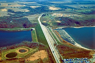
English: Barrier Dam on Saylorville Lake near Polk City, Iowa, USA. The main dam is Saylorville Dam, but in order to fill the lake, this second dam, Barrier Dam had to be constructed on one arm of the lake. |
|||
| Fecha | not specified or unknown | |||
| Fuente |
U.S. Army Corps of Engineers Digital Visual Library Image page Image description page Digital Visual Library home page |
|||
| Autor | U.S. Army Corps of Engineers, photographer not specified or unknown | |||
| Permiso (Reutilización de este archivo) |
|
| Posición de la cámara | | Ubicación de esta y otras imágenes en: OpenStreetMap |
|---|
Historial del archivo
Haz clic sobre una fecha y hora para ver el archivo tal como apareció en ese momento.
| Fecha y hora | Miniatura | Dimensiones | Usuario | Comentario | |
|---|---|---|---|---|---|
| actual | 00:27 3 abr 2007 | | 1500 × 1000 (393 kB) | DanMS | {{Information | Description = {{en|Barrier Dam on Saylorville Lake near Polk City, Iowa, USA. The main dam is Saylorville Dam, but in order to fill the lake, this second dam, Barrier Dam had to be constructed on one arm of the lake. }} | Source |
Usos del archivo
La siguiente página usa este archivo:
Uso global del archivo
Las wikis siguientes utilizan este archivo:
- Uso en en.wikipedia.org
- Uso en en.wikivoyage.org
- Uso en hu.wikipedia.org
- Uso en it.wikivoyage.org
- Uso en ru.wikipedia.org
- Uso en www.wikidata.org