
Archivo:TVA-sites-map.png
No se dispone de una resolución más alta.
TVA-sites-map.png (439 × 325 píxeles; tamaño de archivo: 20 kB; tipo MIME: image/png)
Resumen
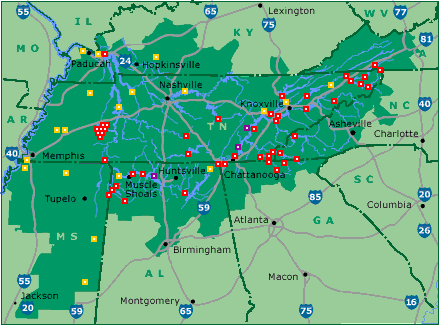
| Descripción | Map of Tennessee Valley Authority sites. Key: red: dam, magenta: nuclear power plant, orange: fossil-fuel plant |
| Fuente | tva.com |
| Autor | Tennessee Valley Authority |
Licencia
| This image is a work of a United States Tennessee Valley Authority employee, taken or made as part of that person's official duties. As a work of the U.S. federal government, the image is in the public domain in the United States. |
Registro original de carga
(All user names refer to en.wikipedia)
- 2005-05-18 01:09 ChrisRuvolo 439×325×8 (19706 bytes) Map of [[Tennessee Valley Authority]] sites. Key: red: [[dam]], magenta: [[nuclear power plant]] orange: [[fossil fuel]] plant Source: [http://www.tva.gov/sites/sites_ie2.htm] [http://www.tva.gov/sites/images/sitesmap3.gif], converted to PNG {{PD-USG
Historial del archivo
Haz clic sobre una fecha y hora para ver el archivo tal como apareció en ese momento.
| Fecha y hora | Miniatura | Dimensiones | Usuario | Comentario | |
|---|---|---|---|---|---|
| actual | 10:03 9 ago 2015 | | 439 × 325 (20 kB) | Kopiersperre | png repaired |
| 11:49 26 may 2007 |  | 439 × 325 (19 kB) | Kordas | {{Information |Description=Map of en:Tennessee Valley Authority sites. Key: red: en:dam, magenta: en:nuclear power plant orange: en:fossil fuel plant Source: [http://www.tva.gov/sites/sites_ie2.htm] [http://www.tva.gov/sites/images |
Usos del archivo
La siguiente página usa este archivo:
Uso global del archivo
Las wikis siguientes utilizan este archivo:
- Uso en da.wikipedia.org
- Uso en he.wikipedia.org
- Uso en nl.wikipedia.org
- Uso en no.wikipedia.org
- Uso en zh.wikipedia.org