
Archivo:Moss Landing California aerial view.jpg

Tamaño de esta previsualización: 800 × 534 píxeles. Otras resoluciones: 320 × 214 píxeles · 640 × 427 píxeles · 1024 × 683 píxeles · 1500 × 1001 píxeles.
Ver la imagen en su resolución original (1500 × 1001 píxeles; tamaño de archivo: 644 kB; tipo MIME: image/jpeg)
| Descripción |
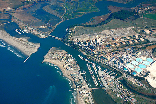
English: Aerial view of Moss Landing, Monterey County, California, USA. The Elkhorn slough runs the area and about 6 miles (8 km) inland. The huge Moss Landing Power Plant is visible at the center.
Coordinates: 36°48′21.95″N 121°46′57.55″W / 36.8060972°N 121.7826528°W |
|||
| Localización | Moss Landing, Monterey County, California, USA | |||
| Fecha | not specified or unknown | |||
| Fuente |
U.S. Army Corps of Engineers Digital Visual Library Image page Image description page Digital Visual Library home page |
|||
| Autor | U.S. Army Corps of Engineers, photographer not specified or unknown | |||
| Permiso (Reutilización de este archivo) |
|
Historial del archivo
Haz clic sobre una fecha y hora para ver el archivo tal como apareció en ese momento.
| Fecha y hora | Miniatura | Dimensiones | Usuario | Comentario | |
|---|---|---|---|---|---|
| actual | 01:35 4 may 2007 | | 1500 × 1001 (644 kB) | DanMS | {{Information | Description = {{en|Aerial view of Moss Landing, Monterey County, California, USA. The Elkhorn slough runs the area and about 6 miles (8 km) inland. The huge Moss Landing Power Plant is visible at the center. }} Coordinates: {{Coor dms| |
Usos del archivo
La siguiente página usa este archivo:
Uso global del archivo
Las wikis siguientes utilizan este archivo:
- Uso en azb.wikipedia.org
- Uso en ceb.wikipedia.org
- Uso en de.wikipedia.org
- Uso en en.wikipedia.org
- Uso en fa.wikipedia.org
- Uso en fr.wikipedia.org
- Uso en nl.wikipedia.org
- Uso en pt.wikipedia.org
- Uso en sr.wikipedia.org
- Uso en uk.wikipedia.org
- Uso en vi.wikipedia.org
- Uso en www.wikidata.org
- Uso en zh.wikipedia.org