
Archivo:Generalgouvernement fur die besetzten polnischen gebiete.png

Tamaño de esta previsualización: 556 × 599 píxeles. Otras resoluciones: 223 × 240 píxeles · 445 × 480 píxeles · 713 × 768 píxeles · 950 × 1024 píxeles · 1610 × 1735 píxeles.
Ver la imagen en su resolución original (1610 × 1735 píxeles; tamaño de archivo: 523 kB; tipo MIME: image/png)
Resumen
| Descripción |
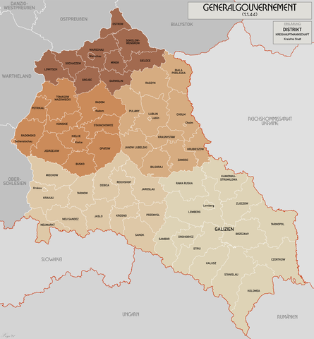
English: Administrative map of the Generalgouvernement für die besetzten polnischen Gebiete. |
| Fecha | |
| Fuente | Trabajo propio |
| Autor | XrysD |
| Otras versiones | File:General Government for the occupied Polish territories.png |
Licencia
Yo, titular de los derechos de autor de esta obra, la publico en los términos de las siguientes licencias:
Este archivo se encuentra bajo la licencia Creative Commons Genérica de Atribución/Compartir-Igual 3.0.
- Eres libre:
- de compartir – de copiar, distribuir y transmitir el trabajo
- de remezclar – de adaptar el trabajo
- Bajo las siguientes condiciones:
- atribución – Debes otorgar el crédito correspondiente, proporcionar un enlace a la licencia e indicar si realizaste algún cambio. Puedes hacerlo de cualquier manera razonable pero no de manera que sugiera que el licenciante te respalda a ti o al uso que hagas del trabajo.
- compartir igual – En caso de mezclar, transformar o modificar este trabajo, deberás distribuir el trabajo resultante bajo la misma licencia o una compatible como el original.

|
Se autoriza la copia, distribución y modificación de este documento bajo los términos de la licencia de documentación libre GNU, versión 1.2 o cualquier otra que posteriormente publique la Fundación para el Software Libre; sin secciones invariables, textos de portada, ni textos de contraportada. Se incluye una copia de la dicha licencia en la sección titulada Licencia de Documentación Libre GNU. |
Puedes usar la licencia que prefieras.
Historial del archivo
Haz clic sobre una fecha y hora para ver el archivo tal como apareció en ese momento.
| Fecha y hora | Miniatura | Dimensiones | Usuario | Comentario | |
|---|---|---|---|---|---|
| actual | 10:11 17 oct 2021 | | 1610 × 1735 (523 kB) | XrysD | Incorporated typos KRUBIESZOW->HRUBIESZOW and CZORTZOW->CZORTKOW |
| 18:12 11 oct 2021 |  | 1610 × 1735 (575 kB) | Kamilhrub | Czortzow → Czortkow | |
| 10:30 6 oct 2021 |  | 1610 × 1735 (575 kB) | Kamilhrub | Corrected name Hrubieszow and southern borders of Bilgoraj, Hrubieszow and Zamosc districts, which didn't change after 1941 (source: Amtliches Gemeinde- und Dorfverzeichnis für das Generalgouvernement auf Grund der Summarischen Bevölkerungsbestandsaufnahme am 1. März 1943) | |
| 09:41 8 may 2015 |  | 1610 × 1735 (438 kB) | RokerHRO | optipng -o7 -i0 → 21.79% decrease | |
| 10:36 19 abr 2015 |  | 1610 × 1735 (560 kB) | XrysD | Komplett neue Karte. Grundkarte: Karte des Deutschen Reiches 1:100k, Karte von Mitteleuropa 1:300k, Mapa Administracyjna Rzeczypospolitej Polska 1:300k (Quelle mapyWIG). | |
| 16:18 27 may 2012 |  | 2299 × 2280 (398 kB) | XrysD | Fixed typos | |
| 19:51 26 may 2012 |  | 2299 × 2280 (396 kB) | XrysD | Changed version to all German Language. Changed all colours to use Bartholomew set. English language version can now be found under File:General Government for the occupied Polish territories.png | |
| 19:45 26 may 2012 |  | 2299 × 2280 (396 kB) | XrysD | Changed version to all German Language. Changed all colours to use Bartholomew set. English language version can now be found under File:General Government for the occupied Polish territories.png | |
| 20:38 23 ene 2009 |  | 2299 × 2280 (391 kB) | XrysD | {{Information |Description= |Source= |Date= |Author= |Permission= |other_versions= }} | |
| 19:36 29 nov 2008 |  | 2299 × 2279 (367 kB) | XrysD | {{Information |Description={{en|1=Administrative map of the Generalgouvernement für die besetzten polnischen Gebiete.}} |Source=Own work by uploader |Author=XrysD |Date=29/11/2008 |Permission= |other_versions= }} <!--{{ImageUpload|full}}- |
Usos del archivo
Las siguientes páginas usan este archivo:
Uso global del archivo
Las wikis siguientes utilizan este archivo:
- Uso en ar.wikipedia.org
- Uso en ast.wikipedia.org
- Uso en ba.wikipedia.org
- Uso en be-tarask.wikipedia.org
- Uso en ca.wikipedia.org
- Uso en cs.wikipedia.org
- Uso en de.wikipedia.org
- Uso en el.wikipedia.org
- Uso en fi.wikipedia.org
- Uso en fr.wikipedia.org
- Uso en fr.wiktionary.org
- Uso en gl.wikipedia.org
- Uso en hu.wikipedia.org
- Uso en it.wikipedia.org
- Uso en sh.wikipedia.org
- Uso en simple.wikipedia.org
- Uso en sr.wikipedia.org
- Uso en sv.wikipedia.org
- Uso en uk.wikipedia.org
- Uso en www.wikidata.org
- Uso en zh.wikipedia.org