
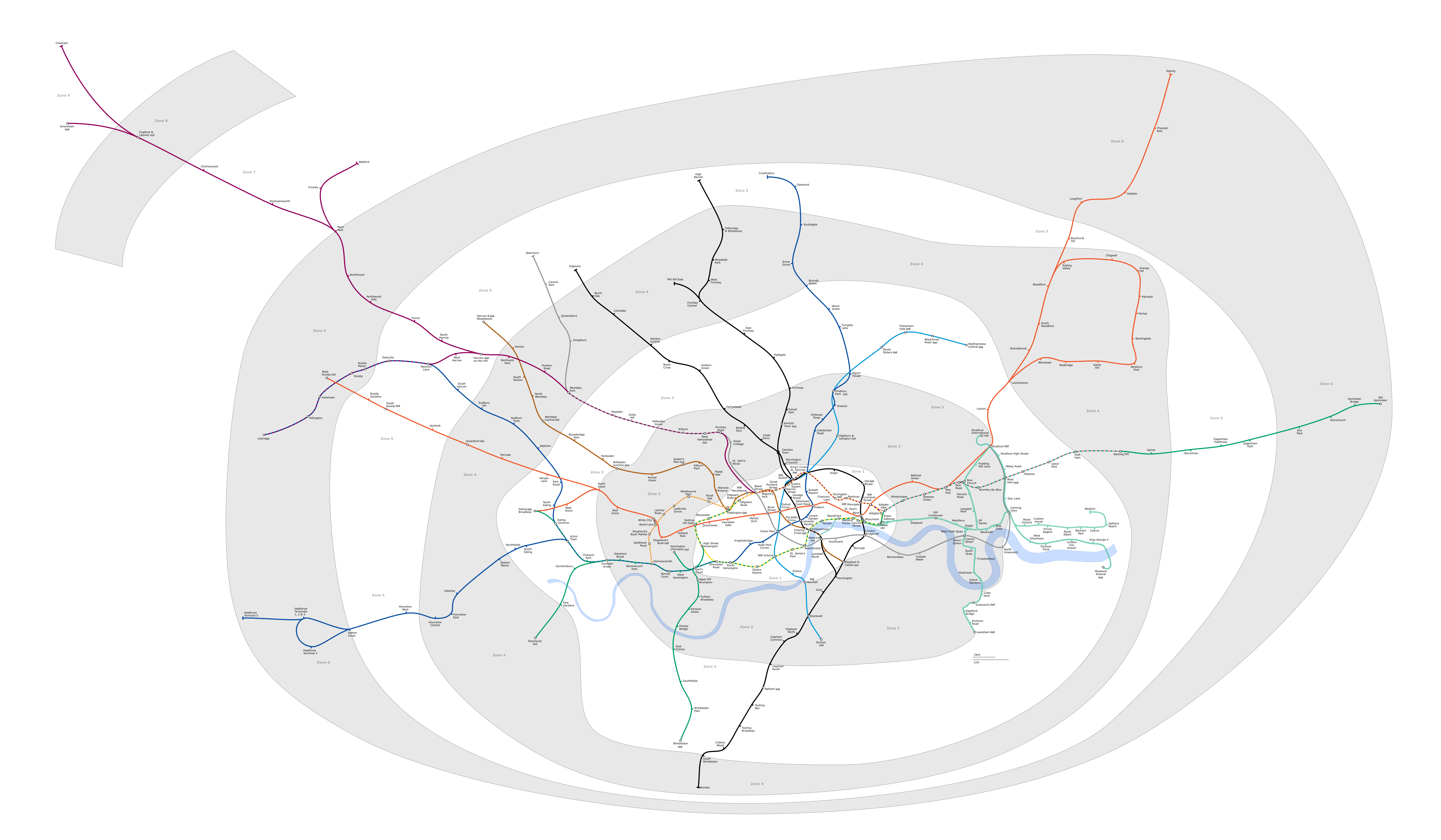
Archivo:London Underground full map.png
Tamaño de esta previsualización: 800 × 467 píxeles. Otras resoluciones: 320 × 187 píxeles · 640 × 373 píxeles · 1024 × 597 píxeles · 1280 × 747 píxeles · 2560 × 1493 píxeles · 6000 × 3500 píxeles.
Ver la imagen en su resolución original (6000 × 3500 píxeles; tamaño de archivo: 1,36 MB; tipo MIME: image/png)
Generated as part of the London Underground geographic maps project by software written by ed g2s • talk and James D. Forrester utilising GPS data.
NB: Routes between stations are interpolated and may not be geographically accurate

|
Se autoriza la copia, distribución y modificación de este documento bajo los términos de la licencia de documentación libre GNU, versión 1.2 o cualquier otra que posteriormente publique la Fundación para el Software Libre; sin secciones invariables, textos de portada, ni textos de contraportada. Se incluye una copia de la dicha licencia en la sección titulada Licencia de Documentación Libre GNU. |
| Este archivo se encuentra bajo la licencia Creative Commons Genérica de Atribución/Compartir-Igual 3.0. | ||
| ||
| Esta etiqueta de licencia fue agregada a este archivo como parte de la actualización de la licencia GFDL. |
Este archivo se encuentra bajo la licencia Creative Commons de Atribución/Compartir-Igual 2.5 Genérica, 2.0 Genérica y 1.0 Genérica.
- Eres libre:
- de compartir – de copiar, distribuir y transmitir el trabajo
- de remezclar – de adaptar el trabajo
- Bajo las siguientes condiciones:
- atribución – Debes otorgar el crédito correspondiente, proporcionar un enlace a la licencia e indicar si realizaste algún cambio. Puedes hacerlo de cualquier manera razonable pero no de manera que sugiera que el licenciante te respalda a ti o al uso que hagas del trabajo.
- compartir igual – En caso de mezclar, transformar o modificar este trabajo, deberás distribuir el trabajo resultante bajo la misma licencia o una compatible como el original.
Upload log
Latest versions of this file are uploaded from wts.wikivoyage-old.org.
Aquí se muestra la página de descripción original. Los siguientes nombres de usuario se refieren a wts.wikivoyage-old.
org:
- 2010-02-11 19:08:44 4100×2374 (1,076,793 bytes) (WT-shared) Peterfitzgerald attempted fix (Import from wikitravel.org/shared)
- 2009-12-20 21:41:21 4000×2312 (827,759 bytes) (WT-shared) Peterfitzgerald increase resolution (Import from wikitravel.org/shared)
- 2009-12-20 00:59:42 3000×1734 (571,486 bytes) (WT-shared) Peterfitzgerald == Summary == {{Imagecredit|credit=[[:wmc:User:DavidCane]], [[:wmc:User:Ed g2s]], Peter Fitzgerald|captureDate=19 December 2009|location=Lon (Import from wikitravel.org/shared)
Historial del archivo
Haz clic sobre una fecha y hora para ver el archivo tal como apareció en ese momento.
| Fecha y hora | Miniatura | Dimensiones | Usuario | Comentario | |
|---|---|---|---|---|---|
| actual | 23:23 4 feb 2018 | | 6000 × 3500 (1,36 MB) | DavidCane | Amend to correspond to svg version |
| 13:04 8 oct 2015 |  | 6000 × 3500 (1,1 MB) | RokerHRO | optipng -o7 -i0 -zc1-9 -zm1-9 -zs0-3 -f0-5 → 19.47% decrease | |
| 03:26 12 ago 2014 |  | 6000 × 3500 (1,36 MB) | Jc86035 | Updated again | |
| 12:07 8 ago 2014 |  | 6000 × 3500 (1,35 MB) | Jc86035 | again, updated from SVG version | |
| 15:15 3 dic 2013 |  | 6000 × 3500 (1,35 MB) | Jc86035 | Updated from SVG at File:London Underground full map.svg | |
| 08:42 22 nov 2012 |  | 4000 × 2320 (274 kB) | Atsirlin | Reverted to version as of 01:42, 6 January 2007: OK, importing new versions was a bad idea... | |
| 08:32 22 nov 2012 |  | 4100 × 2374 (1,03 MB) | OgreBot | (BOT): Uploading old version of file from wts.wikivoyage-old; originally uploaded on 2010-02-11 19:08:44 by (WT-shared) Peterfitzgerald | |
| 08:32 22 nov 2012 |  | 4000 × 2312 (808 kB) | OgreBot | (BOT): Uploading old version of file from wts.wikivoyage-old; originally uploaded on 2009-12-20 21:41:21 by (WT-shared) Peterfitzgerald | |
| 08:32 22 nov 2012 |  | 3000 × 1734 (558 kB) | OgreBot | (BOT): Uploading old version of file from wts.wikivoyage-old; originally uploaded on 2009-12-20 00:59:42 by (WT-shared) Peterfitzgerald | |
| 01:42 6 ene 2007 |  | 4000 × 2320 (274 kB) | Ed g2s | new zone 4 boundary |
Usos del archivo
Las siguientes páginas usan este archivo:
Uso global del archivo
Las wikis siguientes utilizan este archivo:
- Uso en da.wikipedia.org
- Uso en en.wikipedia.org
- Uso en en.wikivoyage.org
- Uso en fr.wikivoyage.org
- Uso en he.wikipedia.org
- Uso en hi.wikipedia.org
- Uso en hu.wikipedia.org
- Uso en ja.wikipedia.org
- Uso en ko.wikipedia.org
- Uso en nap.wikipedia.org
- Uso en nl.wikipedia.org
- Acton Town (metrostation)
- Alperton (metrostation)
- Amersham (metrostation)
- Arnos Grove (metrostation)
- Dagenham East (metrostation)
- Debden (metrostation)
- Dagenham Heathway (metrostation)
- Fairlop (metrostation)
- Finchley Central (metrostation)
- Ickenham (metrostation)
- Station Balham
- Barkingside (metrostation)
- Becontree (metrostation)
- Boston Manor (metrostation)
- Bounds Green (metrostation)
- Brent Cross (metrostation)
- Buckhurst Hill (metrostation)
- Burnt Oak (metrostation)
- Oakwood (metrostation)
- Osterley (metrostation)
- Stanmore (metrostation)
- Gants Hill (metrostation)
- Grange Hill (metrostation)
- Canons Park (metrostation)
- Station Chalfont & Latimer
- Chesham (metrostation)
- Chigwell (metrostation)
- Station Chorleywood
- Cockfosters (metrostation)
- Colindale (metrostation)
- Colliers Wood (metrostation)
- Croxley (metrostation)
- Custom House for ExCeL
- Cyprus (metrostation)
- Queensbury (metrostation)
- Station Upminster
Ver más uso global de este archivo.