
Archivo:Map of the shelling of Yeonpyeong.svg

Tamaño de esta previsualización PNG del archivo SVG: 800 × 573 píxeles. Otras resoluciones: 320 × 229 píxeles · 640 × 458 píxeles · 1024 × 733 píxeles · 1280 × 916 píxeles · 2560 × 1833 píxeles · 912 × 653 píxeles.
Ver la imagen en su resolución original ((Imagen SVG, nominalmente 912 × 653 pixels, tamaño de archivo: 338 kB))
Resumen
| Descripción |
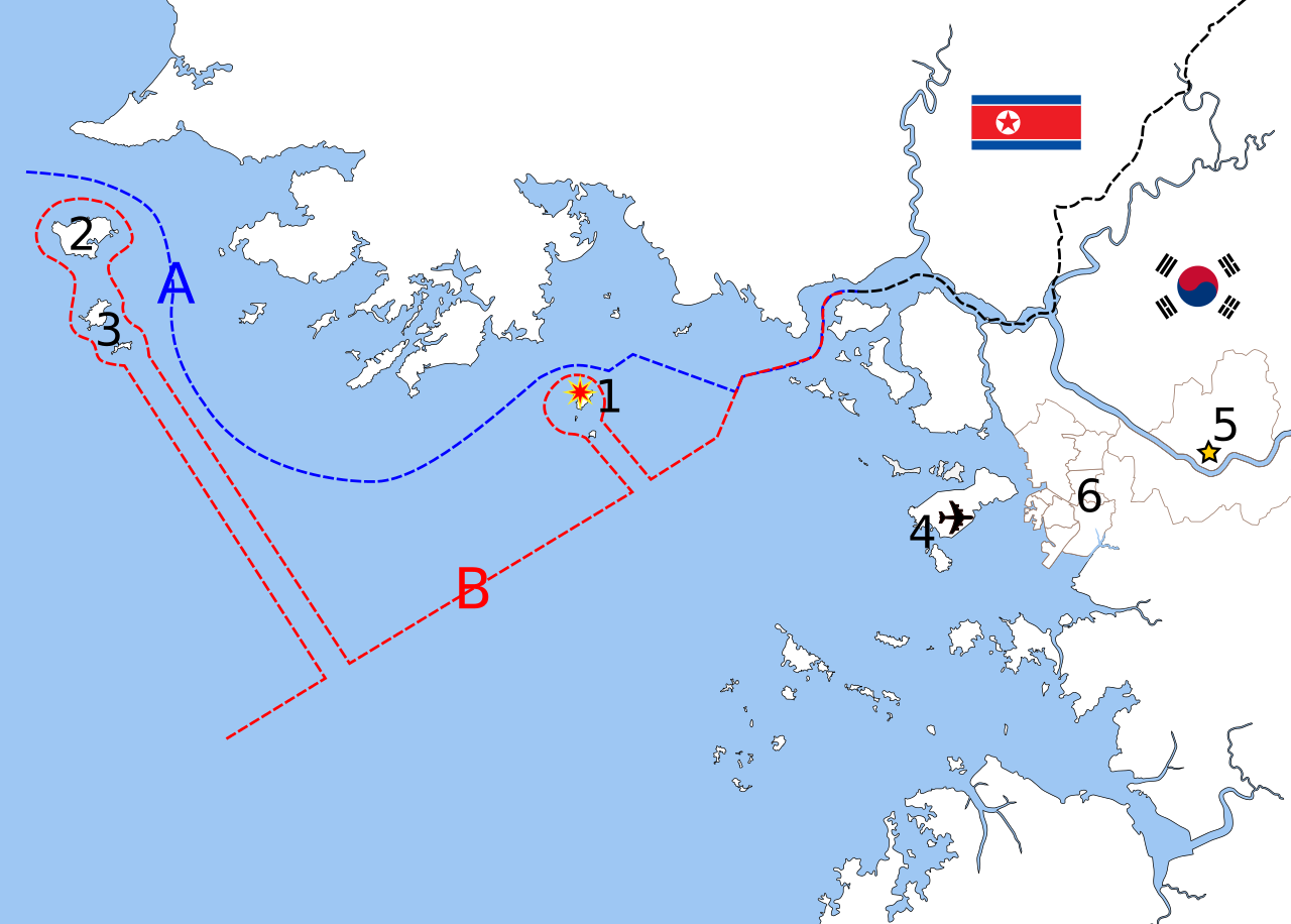
English: Map of the shelling of Yeonpyeong, language neutral version.
Polski: Mapa ostrzału wyspy Yeonpyeong.
中文(简体):延坪岛炮击事件地图,语言中性版本。
中文(繁體):延坪島炮擊事件地圖,語言中性版本。
Deutsch: Karte der Bombardierung von Yeonpyeong, sprachneutrale Version.
Français : Carte du bombardement de Yeonpyeong, version langue-neutral
Nederlands: Kaart van de granaataanval op Yeonpyeong, taalneutrale versie
|
| Fecha | |
| Fuente | Based on File:Inchon islands 2.svg (by Amble) and File:朝韩争议区(延坪岛附近).svg (by 玖巧仔). Modified and converted to language neutral version by Tomchen1989. Flags are from File:Flag of South Korea.svg and File:Flag of North Korea.svg which are in the public domain. The Northern Limit Line and the Military Demarcation Line are according to Xinhua and NYTimes. |
| Autor | See above |
| Otras versiones |
|

Licencia
Este archivo se encuentra bajo la licencia Creative Commons Genérica de Atribución/Compartir-Igual 3.0.
Atribución: Amble, 玖巧仔 and Tomchen1989
- Eres libre:
- de compartir – de copiar, distribuir y transmitir el trabajo
- de remezclar – de adaptar el trabajo
- Bajo las siguientes condiciones:
- atribución – Debes otorgar el crédito correspondiente, proporcionar un enlace a la licencia e indicar si realizaste algún cambio. Puedes hacerlo de cualquier manera razonable pero no de manera que sugiera que el licenciante te respalda a ti o al uso que hagas del trabajo.
- compartir igual – En caso de mezclar, transformar o modificar este trabajo, deberás distribuir el trabajo resultante bajo la misma licencia o una compatible como el original.
Historial del archivo
Haz clic sobre una fecha y hora para ver el archivo tal como apareció en ese momento.
| Fecha y hora | Miniatura | Dimensiones | Usuario | Comentario | |
|---|---|---|---|---|---|
| actual | 10:26 24 nov 2010 | | 912 × 653 (338 kB) | Tomchen1989 | updated |
| 03:54 24 nov 2010 |  | 912 × 653 (337 kB) | Tomchen1989 | {{Information |Description={{en|1=Map of the shelling of Yeonpyeong, language neutral version}} |Source=Based on File:Inchon islands 2.svg (by User:Amble) and File:朝韩争议区(延坪岛附近).svg (by [ |
Usos del archivo
La siguiente página usa este archivo:
Uso global del archivo
Las wikis siguientes utilizan este archivo:
- Uso en en.wikipedia.org
- Uso en fi.wikipedia.org
- Uso en hu.wikipedia.org
- Uso en ja.wikipedia.org
- Uso en ko.wikipedia.org
- Uso en pl.wikipedia.org
- Uso en pt.wikipedia.org